
 United Kingdom
 France
 Germany
 Netherlands
 Sweden
 USA
USA
 Italy
Italy
 Spain
Spain
More From Contributor

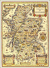


Scotland Philip`s Navigator Atlas
Navigator Road Atlas of Scotland from Philip’s, in an A4 spiral-bound format, using mapping from the publishers’ Navigator series recommended by the Institute of Advanced Motorists. Most of the southern part of the country, up to Stirling and Dunfermline is covered at 1:100, 000 / 1” to 1.6 miles, with the rest, including all the islands and the southern part of Dumfries and Galloway, at 1:200, 000 / 1” to 3.2 mile.The atlas includes a special tourist section with descriptions of best places to visit: towns and villages, historic buildings, outdoor leisure areas and sport facilities, family attractions, museums and galleries, etc, not to forget whisky distilleries! Indexed city centre street plans show Aberdeen, Ayr, Dumfries, Dundee, Fort William, Edinburgh,
Glasgow, Inverness, Oban, Perth, St Andrews, Stirling and Wick, indicating principal traffic arteries, one way streets, car parks, main sights, etc. Also provided is a map of ferry routes to the islands with contact details for ferry companies, plus a route planning map for Britain and Ireland.The main body of the atlas has a clear base map with colouring to indicate national parks or areas of outstanding natural beauty plus woodland and beaches. Spot heights and plenty of names of various geographical features such as peaks, glens, etc provide more landscape information.Road network includes minor roads and tracks and marks separately narrow A and B road. Locations of speed cameras are marked on primary routes and selected A roads, The maps show names of many isolated
building, farms or local landmarks often not marked on maps at scales less detailed than the Ordnance Survey’s Landranger series at 1:50, 000. Railway lines are shown with stations. Symbols highlight various places of interest, sport and recreational facilities, etc. The maps have no geographical coordinates.

Product Description
Reviews/Comments
Add New
Vouchers
No voucher codes found.
Do you know a voucher code for this product or supplier? Add it to Insights for others to use.
Do you know a voucher code for this product or supplier? Add it to Insights for others to use.
 Denmark