More From Contributor

£4.99
Scotland Clans & Tartans Map is a single-sided, illustrated sheet showing the historical clans, clan territories & tartans of the country, accompanied by background & historical information, & an extensive list of family names & their associated clans. On a base map of Scotland showing motorways, A roads, the rail network, airports & tourist information centres, key places of interest & family names are overlaid to cover particular areas of influence held by clans in the early 17th century. Also
Includes:: Historical & background information focusing on the clan system & tartans. A list of clan- & tartan-related places of interest, with contact details & map references. Images of tartans & clan badges (with family names) surrounding the map. An extensive list of current Scottish family names & their associated clans. Images of plant badges & a list of their associated clans or families.
...
Archived Product
£4.99
The Collins Scotland of Old Clans Map is a unique pictorial map showing the ancient territories of the principal Scottish clans in the 17th century, & features Don Pottinger`s (Islay Herald of Arms) distinctive & original artwork of Scottish arms & crest badges. The map
Includes:: * Over 170 arms, the official insignia of clan chiefs, & crest badges.* Territories map of principal clans at the beginning of the 17th century.* Arms of the ancient Scottish principalities.* Locations of the ancient territories held by the clans around the time of King James VI. The map is ideal for those those with an interest in Scottish heraldry, clans & family history. Did you know that Scotland is one of the few countries in the world where a court of heraldry & genealogy operates on a daily basis? The map is based on the map originally conceived & illustrated by the late Sir Iain Moncreiffe of that Ilk, Bart., C.V.O., Q.C., Ph.D., Albany Herald of Arms, & the late Don Pottinger, C.V.O., M.A., D.A., Islay Herald of Arms. Discover the other titles in the series, including Collins Tartans Map of Scotl&, Castles Map of Scotland & Whisky Map of Scotl&.
...
Archived Product
£9.99
Scotland of Old: Clans Wall Map from Collins, size 77.5 x 102cm (30.5 x 40 approx), indicating by colour for each name the general area of influence around the time of King James VI of Scotland (James I of England). The map is surrounded by drawings of over 170 arms, official insignia, crests & mottos of Scottish clans, &

Includes::
panels showing the Royal Arms as on Her Majesty

...
Archived Product
£4.99
Scotland presented at 1:500, 000 on an indexed Ordnance Survey Tour Map with extensive tourist information including an index of selected places of interest. Town navigation maps show main traffic arteries plus principal sights & facilities in central Edinburgh, Glasgow, Aberdeen, Dundee, Dumfries, Fort William, Inverness, Oban, Perth, St Andrews & Stirling. The map indicates narrow roads with passing places &

Includes::
a list of restricted motorway junctions plus a distance table in both miles & kilometres. PLEASE NOTE: cycling routes are not specially highlighted; national trails are shown on a special inset which also indicates locations of main tourist information centres. Current edition of this title was published in February 2016. To see the list of titles in this series please click on the series list – Ordnance Survey’s Tour maps have extra clear, uncluttered cartography. Topography is shown by altitude colouring & relief shading, plus names of local hill or mountain ranges & heights of important peaks. Additional colouring indicates woodlands; boundaries of National Parks or designated Areas of Outstanding Natural Beauty are also marked. Road information very clearly distinguishes between different types of roads, from motorways to small local roads, with distances on main routes. Scenic routes are highlighted; motorway services, tolls, gradients on steep roads & level crossings are marked & towns used in motorway signs as Primary Route Destinations are indicated. Railway lines are shown with stations &, where appropriate, ferry routes are marked. Roads which are part of the national or regional cycle network are highlighted & shown with route numbers; the maps also show the National Trail long-distance hiking paths. An extensive range of symbols indicate various places of interest, including campsites/caravan parks & youth hostels/bunkhouses, historic buildings, sport & recreational facilities, country pubs, etc. The maps have lines of the British National Grid. The place names index is supplemented by a list of selected places of interest plus, in most titles, of market days and/or farmers markets. The maps also include city navigation maps, highlighting main traffic arteries, car parks, principal sights & facilities, etc. For more information please see descriptions & coverage images of individual maps.

...
Archived Product
£16.95
Scotland Panorama, in the Panorama Editions’ series, is a title comprising an especially chosen selection of fifty full spread panoramic colour photographs of eye-catching, interesting & beautiful subject matters, often away from the main tourist routes. Panoramic celebrations illustrate Scotland; realizing in print the touristic viability of a location & stimulating interest in the subject in front of the lens. Literary text introduces the title, describing the place, its people & its history & illuminating the evocative panoramic photographs. ...
Archived Product
£8.99
Navigator Road Atlas of Scotland from Philip’s, in an A4 spiral-bound format, using mapping from the publishers’ Navigator series recommended by the Institute of Advanced Motorists. Most of the southern part of the country, up to Stirling & Dunfermline is covered at 1:100, 000 / 1” to 1.6 miles, with the rest, including all the islands & the southern part of Dumfries & Galloway, at 1:200, 000 / 1” to 3.2 mile. The atlas

Includes::
a special tourist section with descriptions of best places to visit: towns & villages, historic buildings, outdoor leisure areas & sport facilities, family attractions, museums & galleries, etc, not to forget whisky distilleries! Indexed city centre street plans show Aberdeen, Ayr, Dumfries, Dundee, Fort William, Edinburgh, Glasgow, Inverness, Oban, Perth, St Andrews, Stirling & Wick, indicating principal traffic arteries, one way streets, car parks, main sights, etc. Also provided is a map of ferry routes to the islands with contact details for ferry companies, plus a route planning map for Britain & Irel&. The main body of the atlas has a clear base map with colouring to indicate national parks or areas of outstanding natural beauty plus woodland & beaches. Spot heights & plenty of names of various geographical features such as peaks, glens, etc provide more landscape information. Road network

Includes::
minor roads & tracks & marks separately narrow A & B road. Locations of speed cameras are marked on primary routes & selected A roads, The maps show names of many isolated building, farms or local landmarks often not marked on maps at scales less detailed than the Ordnance Survey’s Landranger series at 1:50, 000. Railway lines are shown with stations. Symbols highlight various places of interest, sport & recreational facilities, etc. The maps have no geographical coordinates.


...
Archived Product
£5.99
Reproduction from Soho Publishing of a colourful Scotland Pictorial Plan, size 30 x 40cm (12” x 16” approx), “a Curious yet authentic ...
Archived Product
£4.99
Scotland in the Pocket Guide series from Berlitz; a collection of handy, pocket-sized guides dedicated to an extensive range of cities, regions & countries worldwide. Written in narrative form, individual guides explore the history, main sights & attractions, food & drink, accommodation & local culture of the destination in detail. Each Berlitz pocket guide has a similar format, with colour-coded sections helping readers locate information quickly in addition to distinctive chapters exploring the city or region. An introduction outlines the destination for visitors & a section dedicated to 'A Brief History' actually explores the area in relative depth. A where to go chapter is organized by region & city & is written in prose form with references to individual sites highlighted in bold for clarity. There are also further suggestions on where & when to eat. Recommendations for leisure activities in the region, including sport, nightlife & shopping, are also provided & tailored accordingly for each destination. Handy travel tips are listed alphabetically in a dedicated section, providing practical guidance & helping visitors make the most of their stay. The main hotels, particularly for cities, are also listed in an accommodation section, offering a brief overview with approximate price bandings & relevant contact details. ...
Archived Product
£5.99
Scotland in the Pocket Guide series from Berlitz; a collection of handy, pocket-sized guides dedicated to an extensive range of cities, regions & countries worldwide. Written in narrative form, individual guides explore the history, main sights & attractions, food & drink, accommodation & local culture of the destination in detail. Each Berlitz pocket guide has a similar format, with colour-coded sections helping readers locate information quickly in addition to distinctive chapters exploring the city or region. An introduction outlines the destination for visitors & a section dedicated to `A Brief History` actually explores the area in relative depth. A where to go chapter is organized by region & city & is written in prose form with references to individual sites highlighted in bold for clarity. There are also further suggestions on where & when to eat. Recommendations for leisure activities in the region, including sport, nightlife & shopping, are also provided & tailored accordingly for each destination. Handy travel tips are listed alphabetically in a dedicated section, providing practical guidance & helping visitors make the most of their stay. The main hotels, particularly for cities, are also listed in an accommodation section, offering a brief overview with approximate price bandings & relevant contact details. ...
Archived Product
£1.99
Handy little full colour map of Scotland at a scale of 8.7 miles to 1 inch. Excellent value at GBP1.99 & very detailed for ...
Archived Product

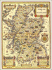
Scotland Philip`s 2019 Road Map

This new edition double-sided Philip`s Scotland Road Map is designed for long-distance driving, and is a convenient size for opening out on a table or in a vehicle. Scotland is shown at 1:330, 000 (5.25 miles to 1 inch), an ideal scale for long distance driving, with major routes and destinations picked out in bold colours. Town-centre plans are provided for Aberdeen, Dundee, Edinburgh and Glasgow. For holiday planning, the map highlights scenic routes and shows car ferry routes, along with camp sites, national parks and many other places of interest.
RIP - This product is no longer available on our network. It was last seen on 25.09.2019

This page now acts as a permanent archive for this product. Add more information using the comments box below to ensure it can still be found by future generations.

Use our search facility to see if it is available from an alternative contributor.
  • Availability: Out Of Stock
  • Supplier: Stanfords
  • SKU: 9781849074469
Availability: In Stock
£4.99

Product Description

This new edition double-sided Philip`s Scotland Road Map is designed for long-distance driving, & is a convenient size for opening out on a table or in a vehicle. Scotland is shown at 1:330, 000 (5.25 miles to 1 inch), an ideal scale for long distance driving, with major routes & destinations picked out in bold colours. Town-centre plans are provided for Aberdeen, Dundee, Edinburgh & Glasgow. For holiday planning, the map highlights scenic routes & shows car ferry routes, along with camp sites, national parks & many other places of interest.

Reviews/Comments

Add New

Intelligent Comparison

Oooops!
We couldn't find anything!
Perhaps this product's unique.... Or perhaps we are still looking for comparisons!
Click to bump this page and we'll hurry up.

Price History

Vouchers

No voucher codes found.
Do you know a voucher code for this product or supplier? Add it to Insights for others to use.

Facebook

Jargon Buster

Inch - Equivalent to approximately 2.5cm
Edinburgh - The capital city of Scotland
vehicle - A manufactured device used to transport people or cargo.
Car - A machine used for transport which runs on roads
Size - is the measurement of how big an object is in space.
Road - a manmade lane or a path that is used to speed up travel.
Ideal - Something that satisfies a perfect criteria.
Convenient - Something that suits and fits well to other activities.

Supplier Information

Stanfords
Stanfords was established in 1853 and opened their iconic Covent Garden flagship store in 1901. They have become the top retailer of maps, travel books and accessories in the UK and arguably offer the largest selection of maps and travel books worldwide. Famous names such as Captain Robert Falcon Scott, Ranulph Fiennes and Michael Palin have purchased from Stanfords. They now have a shop in Bristol and both stores together with other venues operate a calendar of events including talks, book signings and exhibitions. As a specialist map retailer, the map selection is comprehensive and includes road maps, street maps and walking maps from worldwide destinations, as well as a selection of world atlases and wall maps. Books include travel guides and travel literature. Stanfords also stock globes, from miniatures made of blue marble to magnificent floor-standing globes. The website features a selection of interesting articles on travel topics.
Page Updated: 2023-11-12 20:15:36

Community Generated Product Tags

Oh No! The productWIKI community hasn't generated any tags for this product yet!
Menu