
 United Kingdom
 France
 Germany
 Netherlands
 Sweden
 USA
USA
 Italy
Italy
 Spain
Spain
More From Contributor


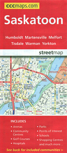
Saskatoon SK
Double-sided, indexed street plan of Saskatoon at 1:25, 000, with additional panels providing at the same scale indexed street plans of other towns in central and northern Saskatchewan: Battleford and Northern Battleford, Humboldt, Kindersley, La Ronge, Lloydminster, Martensville, Meadow Lake, Melfort, Nipawin, Prince Albert, Tisdale and Warman. Also provided is a road map of Saskatchewan at 1:4, 500, 000.Street plans from the MapArt / Canadian Cartographics Corporation / JDM Géo publishing group are usually produced at scales around 1:25, 000 to 1:35, 000 with smaller towns often shown at more detailed scales. All plans have street indexes. Plans of larges cities usually include an enlargement for the downtown area. Plans grouping together several smaller towns often have an
overview map showing the whole of the relevant region. The plans have colouring to indicate commercial, institutional or industrial use, etc. Main traffic arteries are highlighted and one way streets are marked. A range of symbols shows, as appropriate, parking facilities, bus terminals, metro and/or railway stations, various public facilities and services, places of interest, recreational centres, etc. Map legends for cities and towns in the French speaking part of the country are sometimes in French only.To see the list of currently available Canadian street plans and pocket atlases form the MapArt / Canadian Cartographics Corporation / JDM Géo publishing group, including waterproof and tear-resistant FastTrack titles, please click on the series link.
overview map showing the whole of the relevant region. The plans have colouring to indicate commercial, institutional or industrial use, etc. Main traffic arteries are highlighted and one way streets are marked. A range of symbols shows, as appropriate, parking facilities, bus terminals, metro and/or railway stations, various public facilities and services, places of interest, recreational centres, etc. Map legends for cities and towns in the French speaking part of the country are sometimes in French only.To see the list of currently available Canadian street plans and pocket atlases form the MapArt / Canadian Cartographics Corporation / JDM Géo publishing group, including waterproof and tear-resistant FastTrack titles, please click on the series link.

Product Description
Reviews/Comments
Add New
Vouchers
No voucher codes found.
Do you know a voucher code for this product or supplier? Add it to Insights for others to use.
Do you know a voucher code for this product or supplier? Add it to Insights for others to use.
 Denmark