
 United Kingdom
 France
 Germany
 Netherlands
 Sweden
 USA
USA
 Italy
Italy
 Spain
Spain
More From Contributor


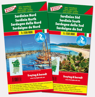
Sardinia F&B Top 10 Tips 2-Map Set
Sardinia at 1:150, 000 in a set of two double-sided, GPS compatible maps from Freytag & Berndt highlighting for recommended cycle routes, long-distance hiking trails and best sights, with descriptions in the accompanying booklet. Plus street plans of central Cagliari, Sassari, Nuoro, Alghero, Oristano and Olbia. The mapping is similar to the publishers’ “Top 10 Tips” one-sheet map of Sardinia at this scale, but with additional information for cyclists.Topography is presented by relief shading and numerous spot heights, with protected areas prominently highlighted. Many place names are in large print to make navigating easier. Road network includes selected local tracks and shows toll routes, entry restrictions and seasonal closures, roads not recommended for caravans,
steep gradients, etc; driving distances are included on many local routes. Scenic roads and routes recommended for cycling are highlighted. Also marked are long-distance hiking trails. Railway lines are shown with stations and ferry connections are marked. The maps indicate locations worth visiting, with 10 best sights cross-referenced to their descriptions in the accompanying booklet. Symbols show other places of interest including campsites and youth hostels. The maps have latitude and longitude lines at intervals at 10’ and include street plans of central Cagliari, Sassari, Nuoro, Alghero, Oristano and Olbia.Accompanying 38-page booklet provides an index listing locations with their postcodes, descriptions of the 10 best sights highlighted on the maps, plus descriptions of
five cycling routes and five hiking trails. Map legend and all the text include English.To see the other titles in F&B’s “Top 10 Tips” series for Italy, including the one-sheet map of Sardinia, please click on the series link.

Product Description
Reviews/Comments
Add New
Vouchers
No voucher codes found.
Do you know a voucher code for this product or supplier? Add it to Insights for others to use.
Do you know a voucher code for this product or supplier? Add it to Insights for others to use.
 Denmark