
 United Kingdom
 France
 Germany
 Netherlands
 Sweden
 USA
USA
 Italy
Italy
 Spain
Spain
More From Contributor


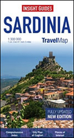
Sardinia Insight Travel Map
Sardinia on a single-sided, indexed road map at 1:300, 000 from Insight. This large map includes many places of interest and a street plan of Cagliari. Insets show ferry routes to mainland Italy and other Mediterranean destinations.The network of main roads is displayed clearly, with distinctions between motorways (with junctions), dual carriageways, main and secondary roads. Markers indicate distances between selected points and symbols highlight filling stations, restaurants and motels en route. Airports, major ports and ferry terminals (with major routes) are marked, as is the rail network. Major towns and cities are displayed, as are many smaller towns and villages.Mountain and hill ranges are named and highlighted with relief shading, and spot heights are shown for the main
peaks. Main lakes and rivers are shown.Many places of interest are annotated on the map, such as: heritage sites, ruins and castles; churches and cathedrals; and national parks, nature reserves, caves and beach resorts.The map itself, excluding the legend and insets, measures 55.5 x 95.5 cm (approximate).Also includes:* An overview of Sardinia, Corsica and the Italian coast at Tuscany, with ferry routes between major destinations.* An inset showing ferry routes in the area around Italy, the French Riviera, the Adriatic, Malta and Tunisia, with contact details for major ferry companies.* A street plan of Cagliari at 1:17, 500 (approximate), with detail of main streets, districts and many places of interest.An index appears on the map, listing placenames on the main map and
streets on the city plans.

Product Description
Reviews/Comments
Add New
Vouchers
No voucher codes found.
Do you know a voucher code for this product or supplier? Add it to Insights for others to use.
Do you know a voucher code for this product or supplier? Add it to Insights for others to use.
 Denmark