More From Contributor
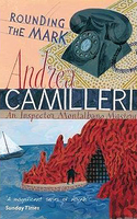
£8.99
When Tom Cutter hires Constantine Shaklin as an engineer in his air freight business, he little realises the extraordinary gifts of his new recruit. Shaklin possesses a religious power which inspires everyone he meets to a new faith & hope for humanity. As Cutter`s business grows across Asia, so does Shaklin`s fame, until he is widely regarded as a unifying deity. Though he struggles to believe Shaklin is indeed divine, the friendship will transform Cutter`s life. ...
Archived Product
£12.99
If the weather outside is frightful, draw up a chair to the fire, get the chesnuts roasting, & find an echo to every mood in this collection of funny, surprising, moving & magical festive stories from some of our greatest authors. Including stories from Laurie Lee, Truman Capote, Kenneth Graham, John Cheever, Sue Towsend, Nancy Mitford, Dylan Thomas, Charles Dickens, John Julius Norwich, P.G. Wodehouse & Stella Gibbons, among many others. ...
Archived Product
£8.95
Jean Cocteau retraces the most celebrated round-the-world voyage of all time: that of Jules Verne`s Phileas Fogg in 1873. Taking up an impulsive challenge from the editor of ” Paris-Soir, ” Cocteau sets off with his very own ` Passepartout` as companion on a picaresque voyage some sixty-three years after his fictional predecessor. He finds that the journey has lost none of its hazards & adventures as he races around the globe in tramp-ship, railway & ocean liner. Observing & recording the frenetic change of scenes from Athens & Alexandria to Bombay, Rangoon, & Yokohama & finally across the United States, Cocteau`s witty, subjective & sometimes outrageous narrative gives this unique travel-memoir a camp & stylish spin. ...
Archived Product
£14.00
Round the World in Eighty Dishes – The World Through the Kitchen Window by Lesley Blanch is a delicate blend of travel anecdotes & recipes inspired by the writer’s frequent trips to destinations around the globe during the first half of the twentieth century. Lesley Blanch, best known for The Wilder Shores of Love & as editor of Vogue, first wrote this book in 1956. The contrast between the post-war restrictions on travelling & eating experienced in England with the writer’s fortune is apparent. Yet, Blanch’s unassuming style & appreciation of her good fate makes this a delightful reading, or better, a skilfully painted view through the kitchen window of distant places. The 80 recipes will lead you on a tour to sample authentic local dishes accompanied by personal witty, amusing & evocative tales of the countries where they were savoured, & cherished. You will find familiar as well as unusual recipes & ingredients: from Cheese Muff from Bavaria & Kaalilaatikko, a sort of pork & herring casserole from Finland to Fouja Djedad, apples stuffed with chicken from Saudi Arabia & Four Pyramids Salad from Mexico. Illustrated throughout with drawings by the author this is a truly precious book, preserving the flavours of dishes & places but also of an era long gone. ...
Archived Product
£3.50
Roundhay Park in 1906 in a fascinating series of reproductions of old Ordnance Survey plans in the Alan Godfrey Editions, ideal for anyone interested in the history of their neighbourhood or family. The map covers the village of Roundhay, on the north side of Leeds, & much of Roundhay Park. Coverage stretches from North Park Grove eastward to Elmet Hall, & from Park Farm & Mansion Hotel southward to Oakwood Lane. Princess Avenue runs through the map, with tramway. Features include Lady Wood, Park Avenue, Gledhow Hill, The Holmsted, the eastern edge of Lidgett Park, Carr Head, refreshment room & other features in the park (boat house, lavatories, shelter, band stand etc), Waterloo Lake, Elmet Hall, St John`s church, etc. A good selection of street directory entries for the neighbourhood is on the reverse, including The Avenue, The Drive, Leeds & Wetherby Road, Oakwood Avenue & Old Park Road. About the Alan Godfrey Editions of the 25” OS Series: Selected towns in Great Britain & Ireland are covered by maps showing the extent of urban development in the last decades of the 19th & early 20th century. The plans have been taken from the Ordnance Survey mapping & reprinted at about 15 inches to one mile (1:4, 340). On the reverse most maps have historical notes & many also include extracts from contemporary directories. Most maps cover about one mile (1.6kms) north/south, one & a half miles (2.4kms) across; adjoining sheets can be combined to provide wider coverage.FOR MORE INFORMATION & A COMPLETE LIST OF ALL AVAILABLE TITLES PLEASE CLICK ON THE SERIES LINK. ...
Archived Product
£11.50
Topographic survey of France at 1:25, 000 in IGN`s excellent TOP25 / Série Bleue series. All the maps are GPS compatible, with a 1km UTM grid plus latitude & longitude lines at 5’ intervals. Contours are at 5m intervals except for mountainous areas where the maps have contours at 10m intervals, vividly enhanced by hill shading & graphics for rocky terrain. Colouring with graphics indicates different types of vegetation or land use (deciduous or coniferous forests, moors, orchards, vineyards, etc). PLEASE NOTE: coverage of France at this scale is currently being revised – the format & the presentation of each title are indicated by the letters at the end of its Sheet Reference number (e.g. 0416ET, 3531ETR, 1923SB, etc.)MAPS WITH FULL TOURIST OVERPRINT & AN ENGLISH MAP LEGEND: all TOP25 maps & the SB editions of Série Bleue have an overprint highlighting waymarked walking trails including long-distance GR routes &, where appropriate, ski routes. Symbols indicate campsites, gîtes d’etape, refuges, equestrian centres & other recreational facilities or sites, tourist information centres, cultural heritage, etc. Towns & locations of particular interest are highlighted.- ET or OT = single-sided TOP25 map covering approx. 29x 21 km / 18x 13 miles.- ETR or OTR = waterproof & tear resistant TOP25 map covering the same area as the corresponding ET or OT number, but double-sided, printed on a smaller size sheet with a good overlap between the sides.- SB = Série Bleue map with full tourist overprint; these maps, first introduced in summer 2014, each cover approx. 29x 24km / 18x 15 miles.SÉRIE BLEUE maps with numbers ending in E (Est) or O (Ouest): most editions now indicate the GR routes, but do not show any other tourist information. Map legend is in French only. Each map covers approx. 14x 20km / 9x 12 miles. ...
Archived Product
£16.99
Roussillon Pays Cathare Guide Vert *FRENCH Edition* in Michelin’s Green Guide series covering France, with all the regions available either in English editions or in French versions. Drawing on Michelin’s long experience, the guides are renowned for their individual ‘star rating’ of sights & attractions. Listings in each guide are organized alphabetically, allowing readers to access information quickly. Towns are given overall star rating, with their sights & attractions also rated individually. Where appropriate, a street plan of the town centre is provided, indicating car parks & accompanied by an index of main streets & a list of sights highlighted on it. For many towns a recommended sightseeing tour is also marked on the plan. Entries for important churches are accompanied by detailed plans. Recommended car tours have overview maps showing road numbers & locations of the sights. Where necessary, the guides give opening hours & contact details. Many entries have an “ Address Book” section with Michelin’s recommendations for where to stay & where to eat. Each guide has a very extensive introductory section with practical information & pre-trip tips, chapters on history, art & culture (particularly strong on architectural styles, explained by excellent drawings), fauna & flora, etc. Fold-out flaps in the book covers provide an overview of the recommended sights and/or car tours.* * French language guides* have a larger number of individual entries than included in the corresponding English titles, as well as more exhaustive descriptions, with wider coverage of local history and/or famous people connected with a given location.* * English language guides* have more recommendations for car tours. The “ Address Book” sections often include shopping suggestions. ...
Archived Product
£10.95
Route 66 The Mother Road Road Atlas from ITMB in a 64-page, A5, paperback format with mapping of the whole route at 1:1, 840, 000 & numerous enlargements presenting city transit maps or more detailed street plans. The whole route from Chicago to Los Angeles is first shown on 12 pages at 1:1, 840, 000. Given the scale of the maps, the course of the northern part of the route is not easy to follow, but from Texas westwards, with fewer local roads, the mapping becomes clearer. This is followed by enlargement showing in more detail the course of Route 66 across Chicago (with city centre street plan), St. Louis, Tulsa, Oklahoma City, Amarillo, Albuquerque, Flagstaff, Las Vegas & Los Angeles (with street plans of central LA, Hollywood, Beverly Hills & central Santa Monica, plus LA metro diagram). Also provided is an enlargement of the San Diego area with a plan of the city centre. The section with mapping of the whole route also contains several notes on its history, printed in rather small size font so requiring good eyesight. ...
Archived Product
£13.99
Route 66 between Los Angeles & Chicago presented in a handy size, A5 paperback atlas using extracts from ITMB’s mapping of USA at 1:1, 000, 000, plus street plans and/or enlargements for main towns along that historic route: LA, Flagstaff, Albuquerque, Amarillo, Oklahoma City, Tulsa, St Louis & Chicago. The course of Route 66 is highlighted on mapping at 1:1, 000, 000 showing the surrounding areas with altitude colouring to indicate the topography. Exit numbers are marked & most sections also show driving distances between the exits. Numerous places of interest & facilities, both along Route 66 & in the surrounding area, are highlighted. Los Angeles (with Hollywood, Beverly Hills & Santa Monica) & Chicago are presented on well-drawn & informative street plans which indicate locations of numerous hotels, restaurants, sights, etc, with an additional diagram of each city’s transport network & a more detailed road map of its environs. Flagstaff, Albuquerque, Amarillo, Oklahoma City, Tulsa & St Louis have overview city maps at scales from 1:50, 000 to 1:120, 000, highlighting the course of Route 66 & the nearby facilities. ...
Archived Product
£15.99
This lavishly illustrated book guides the reader along iconic Route 66 from Chicago to Los Angeles
- from the Great Lakes to the
...
Archived Product

Rounding The Mark

Increasingly disillusioned with his government and the world in general, Inspector Montalbano is considering retirement. He is starting to feel his age, and even his favourite restaurant has closed. But when he bumps into a dead body during a bracing swim, his detective instincts are aroused once more. Particularly when the most likely identity of the victim is a man already long buried.
RIP - This product is no longer available on our network. It was last seen on 25.09.2019

This page now acts as a permanent archive for this product. Add more information using the comments box below to ensure it can still be found by future generations.

Use our search facility to see if it is available from an alternative contributor.
  • External links may include paid for promotion
  • Availability: Out Of Stock
  • Supplier: Stanfords
  • SKU: 9780330442206
Availability: In Stock
£7.99

Product Description

Increasingly disillusioned with his government & the world in general, Inspector Montalbano is considering retirement. He is starting to feel his age, & even his favourite restaurant has closed. But when he bumps into a dead body during a bracing swim, his detective instincts are aroused once more. Particularly when the most likely identity of the victim is a man already long buried.

Reviews/Comments

Add New

Price History

Vouchers

No voucher codes found.
Do you know a voucher code for this product or supplier? Add it to Insights for others to use.

Facebook

Jargon Buster

World - A physical grouping, commonly used to describe earth and everything associated with ti

Supplier Information

Stanfords
Stanfords was established in 1853 and opened their iconic Covent Garden flagship store in 1901. They have become the top retailer of maps, travel books and accessories in the UK and arguably offer the largest selection of maps and travel books worldwide. Famous names such as Captain Robert Falcon Scott, Ranulph Fiennes and Michael Palin have purchased from Stanfords. They now have a shop in Bristol and both stores together with other venues operate a calendar of events including talks, book signings and exhibitions. As a specialist map retailer, the map selection is comprehensive and includes road maps, street maps and walking maps from worldwide destinations, as well as a selection of world atlases and wall maps. Books include travel guides and travel literature. Stanfords also stock globes, from miniatures made of blue marble to magnificent floor-standing globes. The website features a selection of interesting articles on travel topics.
Page Updated: 2023-11-12 20:15:36

Community Generated Product Tags

Oh No! The productWIKI community hasn't generated any tags for this product yet!
Menu