More From Contributor
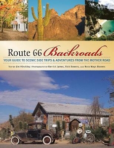
£7.99
Increasingly disillusioned with his government & the world in general, Inspector Montalbano is considering retirement. He is starting to feel his age, & even his favourite restaurant has closed. But when he bumps into a dead body during a bracing swim, his detective instincts are aroused once more. Particularly when the most likely identity of the victim is a man already long buried. ...
Archived Product
£11.50
Topographic survey of France at 1:25, 000 in IGN`s excellent TOP25 / Série Bleue series. All the maps are GPS compatible, with a 1km UTM grid plus latitude & longitude lines at 5’ intervals. Contours are at 5m intervals except for mountainous areas where the maps have contours at 10m intervals, vividly enhanced by hill shading & graphics for rocky terrain. Colouring with graphics indicates different types of vegetation or land use (deciduous or coniferous forests, moors, orchards, vineyards, etc). PLEASE NOTE: coverage of France at this scale is currently being revised – the format & the presentation of each title are indicated by the letters at the end of its Sheet Reference number (e.g. 0416ET, 3531ETR, 1923SB, etc.)MAPS WITH FULL TOURIST OVERPRINT & AN ENGLISH MAP LEGEND: all TOP25 maps & the SB editions of Série Bleue have an overprint highlighting waymarked walking trails including long-distance GR routes &, where appropriate, ski routes. Symbols indicate campsites, gîtes d’etape, refuges, equestrian centres & other recreational facilities or sites, tourist information centres, cultural heritage, etc. Towns & locations of particular interest are highlighted.- ET or OT = single-sided TOP25 map covering approx. 29x 21 km / 18x 13 miles.- ETR or OTR = waterproof & tear resistant TOP25 map covering the same area as the corresponding ET or OT number, but double-sided, printed on a smaller size sheet with a good overlap between the sides.- SB = Série Bleue map with full tourist overprint; these maps, first introduced in summer 2014, each cover approx. 29x 24km / 18x 15 miles.SÉRIE BLEUE maps with numbers ending in E (Est) or O (Ouest): most editions now indicate the GR routes, but do not show any other tourist information. Map legend is in French only. Each map covers approx. 14x 20km / 9x 12 miles. ...
Archived Product
£16.99
Roussillon Pays Cathare Guide Vert *FRENCH Edition* in Michelin’s Green Guide series covering France, with all the regions available either in English editions or in French versions. Drawing on Michelin’s long experience, the guides are renowned for their individual ‘star rating’ of sights & attractions. Listings in each guide are organized alphabetically, allowing readers to access information quickly. Towns are given overall star rating, with their sights & attractions also rated individually. Where appropriate, a street plan of the town centre is provided, indicating car parks & accompanied by an index of main streets & a list of sights highlighted on it. For many towns a recommended sightseeing tour is also marked on the plan. Entries for important churches are accompanied by detailed plans. Recommended car tours have overview maps showing road numbers & locations of the sights. Where necessary, the guides give opening hours & contact details. Many entries have an “ Address Book” section with Michelin’s recommendations for where to stay & where to eat. Each guide has a very extensive introductory section with practical information & pre-trip tips, chapters on history, art & culture (particularly strong on architectural styles, explained by excellent drawings), fauna & flora, etc. Fold-out flaps in the book covers provide an overview of the recommended sights and/or car tours.* * French language guides* have a larger number of individual entries than included in the corresponding English titles, as well as more exhaustive descriptions, with wider coverage of local history and/or famous people connected with a given location.* * English language guides* have more recommendations for car tours. The “ Address Book” sections often include shopping suggestions. ...
Archived Product
£10.95
Route 66 The Mother Road Road Atlas from ITMB in a 64-page, A5, paperback format with mapping of the whole route at 1:1, 840, 000 & numerous enlargements presenting city transit maps or more detailed street plans. The whole route from Chicago to Los Angeles is first shown on 12 pages at 1:1, 840, 000. Given the scale of the maps, the course of the northern part of the route is not easy to follow, but from Texas westwards, with fewer local roads, the mapping becomes clearer. This is followed by enlargement showing in more detail the course of Route 66 across Chicago (with city centre street plan), St. Louis, Tulsa, Oklahoma City, Amarillo, Albuquerque, Flagstaff, Las Vegas & Los Angeles (with street plans of central LA, Hollywood, Beverly Hills & central Santa Monica, plus LA metro diagram). Also provided is an enlargement of the San Diego area with a plan of the city centre. The section with mapping of the whole route also contains several notes on its history, printed in rather small size font so requiring good eyesight. ...
Archived Product
£13.99
Route 66 between Los Angeles & Chicago presented in a handy size, A5 paperback atlas using extracts from ITMB’s mapping of USA at 1:1, 000, 000, plus street plans and/or enlargements for main towns along that historic route: LA, Flagstaff, Albuquerque, Amarillo, Oklahoma City, Tulsa, St Louis & Chicago. The course of Route 66 is highlighted on mapping at 1:1, 000, 000 showing the surrounding areas with altitude colouring to indicate the topography. Exit numbers are marked & most sections also show driving distances between the exits. Numerous places of interest & facilities, both along Route 66 & in the surrounding area, are highlighted. Los Angeles (with Hollywood, Beverly Hills & Santa Monica) & Chicago are presented on well-drawn & informative street plans which indicate locations of numerous hotels, restaurants, sights, etc, with an additional diagram of each city’s transport network & a more detailed road map of its environs. Flagstaff, Albuquerque, Amarillo, Oklahoma City, Tulsa & St Louis have overview city maps at scales from 1:50, 000 to 1:120, 000, highlighting the course of Route 66 & the nearby facilities. ...
Archived Product
£16.99
This is THE all American open road motorcycle adventure. Route 66 stretches over 2, 200 miles connecting LA & Chicago, & it is the story of early twentieth century America. There are plenty of road maps that will put you on & keep you on Route 66... but there’s more. Butler Maps make maps for adventurers (they ride & rate the most scenic & dramatic paved roads in the country). They created twelve scenic loops & side trips that can add a new & exciting dimension to your once in a lifetime experience. ...
Archived Product
£18.99
Much more than just a ribbon of crumbling asphalt, Route 66 today appeals to the world for its nostalgia value
- for the
...
Archived Product
£12.99
Route 66
- Fridge Magnet Set
- Fridge Poetry Get your kicks on Route 66
- or stay at home & create your own travellers` tales


...
Archived Product
£5.95
Route 66 Road Map & Grand Canyon Panoramic Map from GM Johnson & Associates combining an overview map of the route with a 3-D effect panorama map of the Gran d Canyon & extensive notes on the history of Route 66. On one side are two panels showing the course of Route 66 from Chicago to Los Angeles. Presented at the scale of 1:4, 167, 000, they are meant to show only an overview of the route rather than provide detailed coverage with road or junction numbers, etc. Insets provide more detailed picture of the course of Route 66 through Chicago, St. Louis, Tulsa, Oklahoma City, Amarillo, Albuquerque, Flagstaff & the LA conurbation. On the reverse is a very attractive panorama map showing the Grand Canyon in 3-D effect & highlighting campsites, viewpoints, various facilities & services in Grand Canyon Village & North Rim, as well as the main hiking trails. Also provided are extensive notes on the history of Route 66. ...
Archived Product
£17.99
Route 66 Still Kicks is an exhilarating, heartbreaking drive down a forgotten road through unknown America. Author Rick Antonson & his travel nemesis, the inscrutable Peter, patiently journey 2, 400 miles from Chicago to Los Angeles through eight states seeking -- & finding -- all the old parts that remain of Route 66. This travelogue blends surprising vignettes with obscure stories about Route 66-related personalities, among them Al Capone, the Harvey Girls, Salvador Dali, Mickey Mantle, 1930s photojournalist Dorothea Lange, Cyrus Avery (the Father of Route 66), & songster Bobby Troup ” (Get Your Kicks on) Route 66.” Antonson`s fresh perspective on the route`s harsh history, its ebb & flow of popularity & viability along with America`s economic & social upheavals underpaints a canvas of stories about the road`s rise to fame, its segmenting by superhighways, & its fall from grace with the gazetteers -- & Route 66`s entrenchment in legend. ...
Archived Product

Route 66 Backroads

This lavishly illustrated book guides the reader along iconic Route 66 from Chicago to Los Angeles - from the Great Lakes to the heaving Pacific Ocean, through Great Plains and high plateaus, major metropolises and remote country towns. Presenting fifty backroad journeys, this book points the way to gems beyond the tourist trail: quaint frontier communities, ancient native cultures, awe-inspiring natural wonders, and of course the small towns, service stations, eateries that operated when Route 66 was flourishing, some now revitalized, some ruined reminders of a bygone era. Find state parks, wildlife refuges, museums, historic sites, literary landmarks, and much more, all a short drive off Route 66, awaiting the traveler who is looking for more on this legendary
road.Whether you are a nostalgia buff, armchair traveler, group of enthusiasts taking your cars and traveling on holiday, or simply off for a two-week family break, this book is a detailed travel guide and fascinating historic document in one volume, and bound to appeal to the legion of Route 66 fans worldwide.
RIP - This product is no longer available on our network. It was last seen on 25.09.2019

This page now acts as a permanent archive for this product. Add more information using the comments box below to ensure it can still be found by future generations.

Use our search facility to see if it is available from an alternative contributor.
  • External links may include paid for promotion
  • Availability: Out Of Stock
  • Supplier: Stanfords
  • SKU: 9780760328170
Availability: In Stock
£15.99

Product Description

This lavishly illustrated book guides the reader along iconic Route 66 from Chicago to Los Angeles
- from the Great Lakes to the heaving Pacific Ocean, through Great Plains & high plateaus, major metropolises & remote country towns. Presenting fifty backroad journeys, this book points the way to gems beyond the tourist trail: quaint frontier communities, ancient native cultures, awe-inspiring natural wonders, & of course the small towns, service stations, eateries that operated when Route 66 was flourishing, some now revitalized, some ruined reminders of a bygone era. Find state parks, wildlife refuges, museums, historic sites, literary landmarks, & much more, all a short drive off Route 66, awaiting the traveler who is looking for more on this legendary road. Whether you are a nostalgia buff, armchair traveler, group of enthusiasts taking your cars & traveling on holiday, or simply off for a two-week family break, this book is a detailed travel guide & fascinating historic document in one volume, & bound to appeal to the legion of Route 66 fans worldwide.

Reviews/Comments

Add New

Intelligent Comparison

Oooops!
We couldn't find anything!
Perhaps this product's unique.... Or perhaps we are still looking for comparisons!
Click to bump this page and we'll hurry up.

Price History

Vouchers

No voucher codes found.
Do you know a voucher code for this product or supplier? Add it to Insights for others to use.

Facebook

Jargon Buster

Natural - not manmade
Small - something that takes up less space than normal.
Road - a manmade lane or a path that is used to speed up travel.
Family - A group of people that live together made up from parents and children.

Supplier Information

Stanfords
Stanfords was established in 1853 and opened their iconic Covent Garden flagship store in 1901. They have become the top retailer of maps, travel books and accessories in the UK and arguably offer the largest selection of maps and travel books worldwide. Famous names such as Captain Robert Falcon Scott, Ranulph Fiennes and Michael Palin have purchased from Stanfords. They now have a shop in Bristol and both stores together with other venues operate a calendar of events including talks, book signings and exhibitions. As a specialist map retailer, the map selection is comprehensive and includes road maps, street maps and walking maps from worldwide destinations, as well as a selection of world atlases and wall maps. Books include travel guides and travel literature. Stanfords also stock globes, from miniatures made of blue marble to magnificent floor-standing globes. The website features a selection of interesting articles on travel topics.
Page Updated: 2023-11-12 20:15:36

Community Generated Product Tags

Oh No! The productWIKI community hasn't generated any tags for this product yet!
Menu