More From Contributor
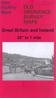
£9.99
The great Italian masterpiece of sensuality & seduction, published in a new English translation
- the first since the Victorian
...
Archived Product
£12.99
From Leonardo da Vinci on the shifting colours of the sky to Charlotte Bronte on the wild moors of Yorkshire, & from DH Lawrence inhabiting the mind of the indomitable tortoise to the intrepid Isabella Bird climbing a Hawaiian volcano, this unusual anthology showcases many voices
- lyrical, awestruck, often deeply reflective. The texts gathered here, many accompanied by rarely seen artwork from early editions, are all grounded in close observation & real love for landscape, & reveal the tradition of nature writing to be deep-rooted & infinitely varied.
...
Archived Product
£27.00
Vegetables have moved from the side dish to the main plate, grains celebrated with colour & flair. It`s a revolution that is bold, inspiring & ever-expanding. Yotam Ottolenghi`s Plenty changed the way people cook & eat. Its focus on vegetable dishes, with the emphasis on flavour, original spicing & freshness of ingredients, caused a revolution not just in this country, but the world over. Plenty More picks up where Plenty left off, with 120 more dazzling vegetable-based dishes, this time organised by cooking method. Grilled, baked, simmered, cracked, braised or raw, the range of recipe ideas is stunning. With recipes including Alfonso mango & curried chickpea salad, Membrillo & stilton quiche, Buttermilk-crusted okra, Candy beetroot with lentils, Seaweed, ginger & carrot salad, & even desserts such as Roasted rhubarb with sweet labneh & Quince poached in pomegranate juice, this is the cookbook that everyone has been waiting for. ...
Archived Product
£5.99
Street plan of Pleven at 1:8, 500, with maps of the Kaylaka Park & the Gorges of the Chernelka River, a road map of the surrounding region, plus a extensive list of various local services such as hotels, banks, shopping, etc. The plan shows bus & trolleybus routes with stops & line numbers & is annotated with symbols highlighting locations various facilities including information centre, hotels, cash dispensers, petrol stations & car repairs, etc. Streets show selected house numbers for easier identification of addresses. Only names of largest streets & some facilities are given in Latin alphabet. All the rest, including the street index is in Cyrillic only. Map legend

Includes::
English. Insets show Kaylaka Park at 1:17.000 with roads, tourist accommodation & places of interest, plus a very basic map of the Gorges of the Chernelka River at 1:25, 000. Also provided is a road & rail map of the Pleven administrative district & the area south of it (no scale is indicated). Names of larger towns are in both scripts The map also

Includes::
an extensive gazetteer of various facilities & services within Pleven, including hotels & other accommodation, & notes about the city & its region. All the information is tri-lingual: Bulgarian, English & German.


...
Archived Product
£11.50
Pleystein in a series of GPS compatible recreational editions of the Bavarian topographic survey at 1:25, 000, with waymarked hiking trails & cycling routes, campsites & youth hostels, etc. Coverage

Includes::
Vohenstrauß, Eslarn, Waidhaus, Moosbach, Georgenberg. Contours used in this map vary between 5 to 20m according to the terrain, with 20m interval predominantly used for hilly areas. Varied colouring show different types of landscape: woods, vineyards, fields etc. Maps in this series feature extensive overprint highlighting local & long-distance footpaths & cycle routes, including King Ludwig Way or different variants of the Way of St James, indicating their waymarking. Symbols highlight different types of accommodation (campsites, youth hostels, refuges, etc), sport & recreational facilities, various places of interest, etc. The maps have a 1-km UTM grid. Map legend & all the text are in German only. To see other titles in this series please click on the series link.

...
Archived Product
£12.99
Topographic survey of France at 1:25, 000 in IGN`s excellent TOP25 / Série Bleue series. All the maps are GPS compatible, with a 1km UTM grid plus latitude & longitude lines at 5’ intervals. Contours are at 5m intervals except for mountainous areas where the maps have contours at 10m intervals, vividly enhanced by hill shading & graphics for rocky terrain. Colouring with graphics indicates different types of vegetation or land use (deciduous or coniferous forests, moors, orchards, vineyards, etc). PLEASE NOTE: coverage of France at this scale is currently being revised – the format & the presentation of each title are indicated by the letters at the end of its Sheet Reference number (e.g. 0416ET, 3531ETR, 1923SB, etc.)MAPS WITH FULL TOURIST OVERPRINT & AN ENGLISH MAP LEGEND: all TOP25 maps & the SB editions of Série Bleue have an overprint highlighting waymarked walking trails including long-distance GR routes &, where appropriate, ski routes. Symbols indicate campsites, gîtes d’etape, refuges, equestrian centres & other recreational facilities or sites, tourist information centres, cultural heritage, etc. Towns & locations of particular interest are highlighted.- ET or OT = single-sided TOP25 map covering approx. 29x 21 km / 18x 13 miles.- ETR or OTR = waterproof & tear resistant TOP25 map covering the same area as the corresponding ET or OT number, but double-sided, printed on a smaller size sheet with a good overlap between the sides.- SB = Série Bleue map with full tourist overprint; these maps, first introduced in summer 2014, each cover approx. 29x 24km / 18x 15 miles.SÉRIE BLEUE maps with numbers ending in E (Est) or O (Ouest): most editions now indicate the GR routes, but do not show any other tourist information. Map legend is in French only. Each map covers approx. 14x 20km / 9x 12 miles. ...
Archived Product
£14.99
` When I am disturbed, even angry, gardening has been a therapy. When I don`t want to talk I turn to Plot 29, or to a wilder piece of land by a northern sea. There, among seeds & trees, my breathing slows; my heart rate too. My anxieties slip away.` As a young boy in 1960s Plymouth, Allan Jenkins & his brother, Christopher, were rescued from their care home & fostered by an elderly couple. There, the brothers started to grow flowers in their riverside cottage. They found a new life with their new mum & dad. As Allan grew older, his foster parents were never quite able to provide the family he & his brother needed, but the solace he found in tending a small London allotment echoed the childhood moments when he grew nasturtiums from seed. Over the course of a year, Allan digs deeper into his past, seeking to learn more about his absent parents. Examining the truths & untruths that he`d been told, he discovers the secrets to why the two boys were in care. What emerges is a vivid portrait of the violence & neglect that lay at the heart of his family. A beautifully written, haunting memoir, Plot 29 is a mystery story & meditation on nature & nurture. It`s also a celebration of the joy to be found in sharing food & flowers with people you love. ...
Archived Product
£8.99
When the renowned aviation hero & rabid isolationist Charles A. Lindbergh defeated Franklin Roosevelt by a landslide inthe 1940 presidential election, fear invaded every Jewish household in America. Not only had Lindbergh publicly blamed the Jews for pushing America towards a pointless war with Nazi Germany, but, upon taking office as the 33rd president of the United States, he negotiated a cordial `understanding` with Adolf Hitler. What then followed in America is the historical setting for this startling new novel by Pulitzer-prize winner Philip Roth, who recounts what it was like for his Newark family during the menacing years of the Lindbergh presidency, when American citizens who happened to be Jews had every reason to expect the worst. ...
Archived Product
£16.99
Andrew De Graff`s stunningly detailed artwork takes readers deep into the landscapes from The Odyssey, Hamlet, Pride & Prejudice, Invisible Man, Lord of the Flies, A Wrinkle in Time, Watership Down, The Handmaid`s Tale, & more. Sure to reignite a love for old favourites & spark fresh interest in more recent works as well, Plotted provides a unique new way of appreciating the lands of the human imagination. ...
Archived Product

Plodder Lane 1908

Plodder Lane in 1908 in a fascinating series of reproductions of old Ordnance Survey plans in the Alan Godfrey Editions, ideal for anyone interested in the history of their neighbourhood or family. She map covers the western part of Farnworth, from Highfield Hall westward to Edge Fold. Majopr features include the Workhouse, southern tip of Townley`s Hospital, Brackley Colliery, Plodder Lane station and engine depot, Hollins. Though a semi-rural map, there is much of historical interest in old mine shafts, etc. On the reverse a `Six Inches to the Mile` map covers a somewhat larger area, including Farnworth itself, though in less detail.About the Alan Godfrey Editions of the 25” OS Series:Selected towns in Great Britain and Ireland are covered by maps showing the extent of urban
development in the last decades of the 19th and early 20th century. The plans have been taken from the Ordnance Survey mapping and reprinted at about 15 inches to one mile (1:4, 340). On the reverse most maps have historical notes and many also include extracts from contemporary directories. Most maps cover about one mile (1.6kms) north/south, one and a half miles (2.4kms) across; adjoining sheets can be combined to provide wider coverage.FOR MORE INFORMATION AND A COMPLETE LIST OF ALL AVAILABLE TITLES PLEASE CLICK ON THE SERIES LINK.
RIP - This product is no longer available on our network. It was last seen on 25.09.2019

This page now acts as a permanent archive for this product. Add more information using the comments box below to ensure it can still be found by future generations.

Use our search facility to see if it is available from an alternative contributor.
  • External links may include paid for promotion
  • Availability: Out Of Stock
  • Supplier: Stanfords
  • SKU: 9781847840875
Availability: In Stock
£3.50

Product Description

Plodder Lane in 1908 in a fascinating series of reproductions of old Ordnance Survey plans in the Alan Godfrey Editions, ideal for anyone interested in the history of their neighbourhood or family. She map covers the western part of Farnworth, from Highfield Hall westward to Edge Fold. Majopr features include the Workhouse, southern tip of Townley`s Hospital, Brackley Colliery, Plodder Lane station & engine depot, Hollins. Though a semi-rural map, there is much of historical interest in old mine shafts, etc. On the reverse a ` Six Inches to the Mile` map covers a somewhat larger area, including Farnworth itself, though in less detail. About the Alan Godfrey Editions of the 25” OS Series: Selected towns in Great Britain & Ireland are covered by maps showing the extent of urban development in the last decades of the 19th & early 20th century. The plans have been taken from the Ordnance Survey mapping & reprinted at about 15 inches to one mile (1:4, 340). On the reverse most maps have historical notes & many also include extracts from contemporary directories. Most maps cover about one mile (1.6kms) north/south, one & a half miles (2.4kms) across; adjoining sheets can be combined to provide wider coverage.FOR MORE INFORMATION & A COMPLETE LIST OF ALL AVAILABLE TITLES PLEASE CLICK ON THE SERIES LINK.

Reviews/Comments

Add New

Intelligent Comparison

Oooops!
We couldn't find anything!
Perhaps this product's unique.... Or perhaps we are still looking for comparisons!
Click to bump this page and we'll hurry up.

Price History

Vouchers

No voucher codes found.
Do you know a voucher code for this product or supplier? Add it to Insights for others to use.

Facebook

Jargon Buster

Contemporary - Modern era design
Engine - A machine designed to convert fuel into motion
Contemporary - A design reference to indicate post war modern design
History - Anything that happens in the past. An acedemic subject.
edge - Enhanced data rates for GSM evolution also known as enhanced GPRS. A mobile phone technology with improved data transmission rates.
edge - The point at which two surfaces meet
Contemporary - An object that is living in the same time.
Hall - A room at the inside of an entrance of a house.
Ideal - Something that satisfies a perfect criteria.
Family - A group of people that live together made up from parents and children.

Supplier Information

Stanfords
Stanfords was established in 1853 and opened their iconic Covent Garden flagship store in 1901. They have become the top retailer of maps, travel books and accessories in the UK and arguably offer the largest selection of maps and travel books worldwide. Famous names such as Captain Robert Falcon Scott, Ranulph Fiennes and Michael Palin have purchased from Stanfords. They now have a shop in Bristol and both stores together with other venues operate a calendar of events including talks, book signings and exhibitions. As a specialist map retailer, the map selection is comprehensive and includes road maps, street maps and walking maps from worldwide destinations, as well as a selection of world atlases and wall maps. Books include travel guides and travel literature. Stanfords also stock globes, from miniatures made of blue marble to magnificent floor-standing globes. The website features a selection of interesting articles on travel topics.
Page Updated: 2023-11-12 20:15:36

Community Generated Product Tags

Oh No! The productWIKI community hasn't generated any tags for this product yet!
Menu