
 United Kingdom
 France
 Germany
 Netherlands
 Sweden
 USA
USA
 Italy
Italy
 Spain
Spain
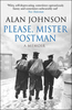
More From Contributor


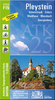


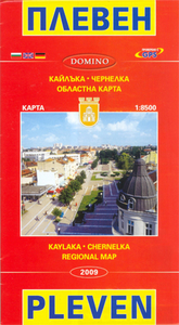
Pleven
Street plan of Pleven at 1:8, 500, with maps of the Kaylaka Park and the Gorges of the Chernelka River, a road map of the surrounding region, plus a extensive list of various local services such as hotels, banks, shopping, etc.The plan shows bus and trolleybus routes with stops and line numbers and is annotated with symbols highlighting locations various facilities including information centre, hotels, cash dispensers, petrol stations and car repairs, etc. Streets show selected house numbers for easier identification of addresses. Only names of largest streets and some facilities are given in Latin alphabet. All the rest, including the street index is in Cyrillic only. Map legend includes English.Insets show Kaylaka Park at 1:17.000 with roads, tourist accommodation and places
of interest, plus a very basic map of the Gorges of the Chernelka River at 1:25, 000. Also provided is a road and rail map of the Pleven administrative district and the area south of it (no scale is indicated). Names of larger towns are in both scriptsThe map also includes an extensive gazetteer of various facilities and services within Pleven, including hotels and other accommodation, and notes about the city and its region. All the information is tri-lingual: Bulgarian, English and German.
of interest, plus a very basic map of the Gorges of the Chernelka River at 1:25, 000. Also provided is a road and rail map of the Pleven administrative district and the area south of it (no scale is indicated). Names of larger towns are in both scriptsThe map also includes an extensive gazetteer of various facilities and services within Pleven, including hotels and other accommodation, and notes about the city and its region. All the information is tri-lingual: Bulgarian, English and German.

Product Description
Reviews/Comments
Add New
Intelligent Comparison
Archived Product
Eleven Stanfords
£7.99
Vouchers
No voucher codes found.
Do you know a voucher code for this product or supplier? Add it to Insights for others to use.
Do you know a voucher code for this product or supplier? Add it to Insights for others to use.
 Denmark