
 United Kingdom
 France
 Germany
 Netherlands
 Sweden
 USA
USA
 Italy
Italy
 Spain
Spain
More From Contributor


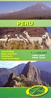
Peru
Double-sided, indexed general map of Peru, dividing the country north/south with a generous overlap. Vivid hill-shading shows the relief, with altitudes for passes and selected peaks marked, and highland regions named. The clear road detail distinguishes unsurfaced routes, and shows some tracks. Intermediate driving distances are marked on many routes. Railways have been omitted from the detail, but internal administrative boundaries and names are clearly marked, and major oil pipelines are drawn (nb. these are not identified as such in the legend). Many reserves and protected areas are shown, and symbols indicate airports, airfields, harbours, beaches, spas, archeological sites, lighthouses and selected places of interest. Latitude and longitude are marked at 1
Product Description
Reviews/Comments
Add New
Intelligent Comparison
Archived Product
Peru Stanfords
£12.79
Archived Product
Peru Stanfords
£4.79
Archived Product
Peru Stanfords
£15.99
Archived Product
Peru Stanfords
£9.95
Archived Product
Peru Stanfords
£9.50
Archived Product

Peru Stanfords
£17.50
Archived Product
Peru Stanfords
£10.99
Archived Product

Perugia Stanfords
£9.99
Vouchers
No voucher codes found.
Do you know a voucher code for this product or supplier? Add it to Insights for others to use.
Do you know a voucher code for this product or supplier? Add it to Insights for others to use.
 Denmark