
 United Kingdom
 France
 Germany
 Netherlands
 Sweden
 USA
USA
 Italy
Italy
 Spain
Spain
More From Contributor

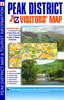

Peak District And Derbyshire
Peak District and Derbyshire at 1:100, 000 on the Ordnance Survey Tour Map No. 4, extending from the eastern fringes of Manchester in the north-west to the National Forest and Loughborough in the south. Insets show town navigation maps of Sheffield, Nottingham, Derby, Ashbourne, Matlock with Matlock Bath, Chesterfield, Buxton, and Burton upon Trent, plus an overview of the whole area with cycle routes and national hiking trails. Also included are lists of selected places of interest, market days and farmer markets.Edition E; Publication date July 2011About this series:Ordnance Survey
Product Description
Reviews/Comments
Add New
Vouchers
No voucher codes found.
Do you know a voucher code for this product or supplier? Add it to Insights for others to use.
Do you know a voucher code for this product or supplier? Add it to Insights for others to use.
 Denmark