
 United Kingdom
 France
 Germany
 Netherlands
 Sweden
 USA
USA
 Italy
Italy
 Spain
Spain
More From Contributor


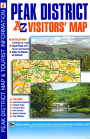
Peak District A-Z Visitors` Map
Peak District Visitors` Map at 1.8” to 1 mile (1:115, 200) from A-Z with prominent highlighting of places of interest also listed in a separate index, plus street plans of Matlock and Matlock Bath, Buxton, Glossop, Bakewell, Castleton and Ashbourne. The current edition of this map was published in 2013.Coverage extends to Manchester, Huddersfield, Wakefield, Rotherham, Sheffield, Chesterfield, Stoke on Trent, Newcastle-under-Lyme and Macclesfield. Topography of this lovely region is shown by altitude colouring with spot heights and names of moors, hills and other geographical features. Numerous places of interest are very prominently highlighted. Road network has gradient markings on steep roads, etc. Railway lines are shown with names of stations. The map has British
national grid lines for GPS users. Two separate indexes list towns/villages and sights, all grouped thematically from abbeys or animal collections to wildlife parks and visitors’ centres. The main map is surrounded by insets with street plans, annotated with tourist information and lists of sights in Matlock and Matlock Bath, Buxton, Glossop, Bakewell, Castleton and Ashbourne.
national grid lines for GPS users. Two separate indexes list towns/villages and sights, all grouped thematically from abbeys or animal collections to wildlife parks and visitors’ centres. The main map is surrounded by insets with street plans, annotated with tourist information and lists of sights in Matlock and Matlock Bath, Buxton, Glossop, Bakewell, Castleton and Ashbourne.

Product Description
Reviews/Comments
Add New
Vouchers
No voucher codes found.
Do you know a voucher code for this product or supplier? Add it to Insights for others to use.
Do you know a voucher code for this product or supplier? Add it to Insights for others to use.
 Denmark