More From Contributor
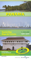
£13.99
Pamir Mountains at 1:500, 000 in a series of maps of Tajikistan & the adjoining areas of the neighbouring countries, providing coverage from Samarkand to Kashgar. The maps have been produced under the auspices of the Swiss Agency for Development & Cooperation & each title

Includes::
information on the area’s culture, economy, history, etc. The maps have contours at 200m intervals, enhanced by relief shading, numerous spot heights, plus names of peaks & mountain passes. Road network

Includes::
dirt tracks & trekking routes are marked. Numerous population centres are finely graded according to the number of inhabitants. The maps also show local administrative boundaries.A wide range of symbols mark various places of interest & general facilities: cultural sites including museums, shrines, archaeological sites, etc; natural sites such as caves, interesting geological formations, waterfalls & springs; general facilities including accommodation, bazaars, fuel supplies, information centres, border crossings, etc. The maps have a latitude & longitude grid as indicated in the individual descriptions. On the reverse each map has a description of the area, its history, culture, economy, ecology, etc. &

Includes::
a street plan of the main town. Map legend & all the text are in English. IN THIS TITLE: latitude grid lines at 20’ intervals, with longitude at 30’. On the reverse the extensive text about this area is supplemented street plans of Khorog & Murghab indicating various places of interest & facilities, plus an enlargement showing in greater detail at 1:110, 000 the Savnob – Usoi Dam area west of Lake Sarez. Current edition of this map was revised in 2011.


...
Archived Product
£6.95
Topographic coverage of mainland Spain at 1:50, 000 in the MTN50 (Mapa Topográfico Nacional) series from the Centro Nacional de Información Geografica, the country’s civilian survey organization. The maps have contours at 20m intervals, enhanced by relief shading, plus colouring and/or graphics to show different types of terrain, vegetation or land use. Boundaries of national parks & other protected areas are marked. In addition to all the usual information featured on topographic mapping at this scale, detailed presentation of the road & rail networks, rural tracks & paths, etc, the maps also show campsites & mountain refuges. On more recent editions some GRs, the official long-distance hiking routes, are also marked (although not as clearly as on hiking maps from other publishers). Each map covers 29.5x 18.5 km (with adjustments in the border or coastal areas). The maps have a 1-km UTM grid, plus margin ticks for latitude & longitude at 1` intervals. Map legend is in Spanish only.HOW TO CHOOSE THE RIGHT 50K MAP: all the titles in CNIG’s 200K Provincial Road Maps series at 1:200, 000 are overprinted with the grid for the 1:50, 000 maps & can be used to see the area covered by each 50K title. TO SEE THE LIST OF TITLES IN THIS SERIES PLEASE CLICK ON THE SERIES LINK.PLEASE NOTE
- MAP TITLES: the grids shown on our website serve both the civilian & the military 1:50, 000 topographic series. Although the areas covered by maps in both series are identical (apart from some border or coastal sheets), occasionally map titles differ – only one title is shown on the grid, usually the military one. In Galicia, the Basque country & in the Catalan speaking areas the tendency now is to use local place names rather than the often better known Castilian ones. Where possible, both versions are included in our titles. Map titles listed on our website are based on information received by us at the time of publication, but sometimes maps arrive showing a completely different title! As long as the map number is as ordered, the correct map has been supplied.
...
Archived Product
£5.99
Michelin’s street plan of Pamplona at 1:8, 000 is primarily designed to be used for access to & travel across the city by car, given its wide coverage of the outer suburbs & detailed presentation of the surrounding motorway network. Main traffic routes across the city are highlighted, with motorway junctions clearly laid out. One way streets & locations of car parks are indicated. The plan highlights & names public buildings & various facilities. Street index is on the same side as the map. Map legend

Includes::
English. To see the list of titles in this series please click on the series link.

...
Archived Product
£7.99
Pamplona/ Iruña on an indexed street plan at 1:9, 200 from Telstar Distrimapas, Spain’s leading publisher of city maps, plus an indexed road map of the Navarra province with suggestions for five sightseeing routes. On one side is an indexed street plan of the city indicating locations of car parks, taxi ranks, petrol stations, etc., with main public buildings & places interest clearly named. On the reverse is an indexed road map of the Navarra province at 1:300, 000 with altitude colouring to show the topography & symbols highlighting various places of interest. (Please note: road network may not necessarily be up to date). Also provided are descriptions, in Spanish only, of five sightseeing routes in the province. ...
Archived Product
£13.99
Pan-Americana North Travel Atlas from ITMB in a handy A5, paperback format showing the course of the Pan-American Highway from its northern point in Prudhoe Bay in Alaska, across western Canada & USA & along the Pacific coast of Mexico & Central America, to Yaviza in southern Panama. Several city centre street plans are included. The atlas has the cartography of various ITMB country & regional maps, so scales vary. Maps for the US & Canadian parts of the route are at 1:1, 500, 000 for Alaska & Yukon, 1:900, 000 for British Columbia, & 1:1, 000, 000 for Washington State, Oregon & California. Street plan for that part of the route cover Whitehorse AK, Watson Lake, Victoria & Vancouver in Canada, plus Seattle, San Francisco, Los Angeles & San Diego on the Pacific coast of US. Mexico is covered at 1:1, 000, 000 & the Central American states at a slightly smaller scale of 1:1, 100, 000, with an enlargement for the Panama Canal Zone & accompanying street plans of Ensenada, La Paz, Mexicali, San Jose del Cabo, & Tijuana in Mexico; no plans of Central American cities are included. The countryside surrounding the Pan-American Highway in presented on mapping with altitude colouring; heights are given in metres within Canada, Mexico & Central America, & in feet in the US. On mapping of Alaska/ Yukon, Mexico & the Central American countries locations of petrol stations are marked. Symbols highlight various places of interest. Some of the sections have latitude & longitude lines, & the atlas is indexed. The size of street plans varies from two pages for the larger US & Canadian cities, to smaller half- or quarter-page insets elsewhere. All highlight selected accommodation and/or other facilities. ...
Archived Product
£13.59
Panama in the Countries & Regions series from Lonely Planet, market-leading comprehensive guides aimed at independent travellers & serving a large range of international destinations. Frank & informal in style, the guides explore an extensive range of sights, activities, accommodation, restaurants & nightlife & are designed for practical use while travelling on the road. Written & researched by a team of experts, each book is independent in its recommendations & suggestions, often offering individual takes on individual destinations. Widely recognised for their reliability, each Lonely Planet country & region guide has the same layout. Introductory sections profile the destination with individual chapters on particular highlights, getting started, (including when to go) itineraries, history, culture, arts, food & drink & the environment. Each guide is organised geographically by region, with individual sections detailing an extensive range of sights, places of interest, attractions, restaurants, nightlife, accommodation & any local activities. The guides have detailed explanations of historical context where relevant. There is also practical guidance on ...
Archived Product
£13.59
Panama in the Countries, Regions & Cities series from Rough Guides; comprehensively detailed guidebooks specifically designed for independent travellers & serving a range of worldwide destinations. Widely recognised for their free editorial style, Rough Guide authors are allowed to express their personal opinions on a range of subjects. Although sometimes controversial, this editorial stance allows readers to experience more detailed & personal takes on each destination, a feature often more limited in other guidebooks. Cultural & historical nuances are explored in significant depth throughout the text & descriptions on the ambience of individual settings alongside personal recommendations, particularly in cities, are notably prevalent. Each Rough Guide in the Countries, Regions & Cities series has a similar layout. A ...
Archived Product
£14.99
Frommer's: The best trips start here. Experience a place the way the locals do. Enjoy the best it has to offer. This guide provides expert advice on the best beaches, bird watching spots, & ecolodges, as well as recommendations on what to see & do in Panama City. It

Includes::
outspoken opinions on what's worth your time & what's not. It also provides exact prices, so you can plan the perfect trip whatever your budget. It contains off the beaten path experiences & undiscovered gems, plus new takes on top attractions.

...
Archived Product
£16.99
From a cosmopolitan capital alongside the expanding Panama Canal to sugar-sand beaches, mist-capped highlands & rainforests teeming with creatures, Panama is both full-on adventure & blissful escape. Carolyn Mc Carthy, Lonely Planet Writer
Getting you to the heart of a place
    Amazing experiences Inspirational images, author recommendations & the best of local knowledge. Plan the perfect trip Planning features & top itineraries give you the freedom to create your ideal trip. Get off the beaten track Our authors uncover local secrets that will make your trip unique. Special Features Tips for first-time travelers Outdoor adventures advice Casco Viejo city walk Cultural & wildlife essays We tell it like it is
    Our job is to make amazing travel experiences happen. We visit the places we write about each & every edition. We never take freebies for positive coverage, so you can always rely on us to tell it like it is.


...
Archived Product
£10.99
Panama at 1:500, 000 on a double-sided indexed map from Mapas Na Turismo with very clear presentation of the country’s topography, tourist information & enlargements for most visited areas. Excellent use of relief shading & altitude colouring gives an almost 3-D presentation of the terrain. National parks & other protected areas are clearly marked. Additional graphics indicate mangroves & yolillal palm tree swamps. Road network

Includes::
seasonal tracks & indicates driving distances on main routes & locations of fuel supplies. Places of interest are highlighted & various symbols also mark locations with tourist accommodation, beaches, surfing & diving sites, hot springs, etc. The map divides the country east/west with a very generous overlap between the sides &

Includes::
an index of localities. Latitude & longitude lines are drawn at 10’ intervals. Map legend is in Spanish & English. Enlargements show the Panama Canal & Bocas del Toro Archipelago at 1:200, 000, with a further enlargement at 1:50, 000 of the Isla Barra Colorado within the Canal Zone.


...
Archived Product

Panama

Panama on an indexed, double-sided map from ITMB, printed on waterproof and tear-resistant plastic paper, with large, clear street plan of central Panama City highlighting various places of interest and tourist facilities, including 18 selected hotels.The map divides the country east/west, with some overlap between the two sides. Topography is shown by altitude colouring with spot heights and names of mountain ranges. Swaps, mangrove and salt marshes are marked, and national parks or protected areas and Indian Reserves highlighted.The map shows the country
RIP - This product is no longer available on our network. It was last seen on 25.09.2019

This page now acts as a permanent archive for this product. Add more information using the comments box below to ensure it can still be found by future generations.

Use our search facility to see if it is available from an alternative contributor.
  • External links may include paid for promotion
  • Availability: Out Of Stock
  • Supplier: Stanfords
  • SKU: 9781553413585
Availability: In Stock
£9.95

Product Description

Panama on an indexed, double-sided map from ITMB, printed on waterproof & tear-resistant plastic paper, with large, clear street plan of central Panama City highlighting various places of interest & tourist facilities, including 18 selected hotels. The map divides the country east/west, with some overlap between the two sides. Topography is shown by altitude colouring with spot heights & names of mountain ranges. Swaps, mangrove & salt marshes are marked, & national parks or protected areas & Indian Reserves highlighted. The map shows the country

Reviews/Comments

Add New

Price History

Vouchers

No voucher codes found.
Do you know a voucher code for this product or supplier? Add it to Insights for others to use.

Facebook

Jargon Buster

Paper - A thin sheet mainly used for writing. Available in a variety of colours. Made mainly from wood pulp.
Plastic - A generic term for a synthetic product used in the manufacture of products
Waterproof - Resistant to water, usualy specified by depth in metres
Large - something that takes up more space than normal.
Resistant - Something that can repel against something.
Altitude - Something that can be quite high in relation to sea or ground level.

Supplier Information

Stanfords
Stanfords was established in 1853 and opened their iconic Covent Garden flagship store in 1901. They have become the top retailer of maps, travel books and accessories in the UK and arguably offer the largest selection of maps and travel books worldwide. Famous names such as Captain Robert Falcon Scott, Ranulph Fiennes and Michael Palin have purchased from Stanfords. They now have a shop in Bristol and both stores together with other venues operate a calendar of events including talks, book signings and exhibitions. As a specialist map retailer, the map selection is comprehensive and includes road maps, street maps and walking maps from worldwide destinations, as well as a selection of world atlases and wall maps. Books include travel guides and travel literature. Stanfords also stock globes, from miniatures made of blue marble to magnificent floor-standing globes. The website features a selection of interesting articles on travel topics.
Page Updated: 2023-11-12 20:15:36

Community Generated Product Tags

Oh No! The productWIKI community hasn't generated any tags for this product yet!
Menu