
 United Kingdom
 France
 Germany
 Netherlands
 Sweden
 USA
USA
 Italy
Italy
 Spain
Spain
More From Contributor


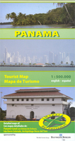
Panama
Panama at 1:500, 000 on a double-sided indexed map from Mapas NaTurismo with very clear presentation of the country’s topography, tourist information and enlargements for most visited areas. Excellent use of relief shading and altitude colouring gives an almost 3-D presentation of the terrain. National parks and other protected areas are clearly marked. Additional graphics indicate mangroves and yolillal palm tree swamps.Road network includes seasonal tracks and indicates driving distances on main routes and locations of fuel supplies. Places of interest are highlighted and various symbols also mark locations with tourist accommodation, beaches, surfing and diving sites, hot springs, etc. The map divides the country east/west with a very generous overlap between the sides and
includes an index of localities. Latitude and longitude lines are drawn at 10’ intervals. Map legend is in Spanish and English.Enlargements show the Panama Canal and Bocas del Toro Archipelago at 1:200, 000, with a further enlargement at 1:50, 000 of the Isla Barra Colorado within the Canal Zone.
includes an index of localities. Latitude and longitude lines are drawn at 10’ intervals. Map legend is in Spanish and English.Enlargements show the Panama Canal and Bocas del Toro Archipelago at 1:200, 000, with a further enlargement at 1:50, 000 of the Isla Barra Colorado within the Canal Zone.

Product Description
Reviews/Comments
Add New
Vouchers
No voucher codes found.
Do you know a voucher code for this product or supplier? Add it to Insights for others to use.
Do you know a voucher code for this product or supplier? Add it to Insights for others to use.
 Denmark