More From Contributor

£9.99
Sturdy, waterproof & tear-resistant map from ITMB combining indexed street plans of Oslo & Bergen at 1:10, 000 with, on the reverse, a road map of southern Norway, plus diagrams of the capital’s metro lines & of the rail link from Oslo to Bergen & the Sognefjord. On one side are the two street plans with their indexes. The Oslo plan covers the inner districts of the city, extending north to the Ring 2 road. Tram & metro lines, both with numbers & stops, are prominently marked. The plan also shows local ferry connections. One way streets & locations of petrol stations are indicated. Symbols show selected hotels, various public buildings & places of interest, shopping centres, numerous foreign embassies, etc. A separate diagram shows the metro, tram & commuter rail network. Also included is a map of the Oslo conurbation at 1:77, 500 showing road & rail connections. The plan of Bergen covers the central part of the city, extending inland to the railway station & the E16/E39 motorway. Ferry terminals, both local & international, are marked. Also included here is a diagram of the train line linking Oslo with Bergen & the ferry connection in Flåm on the Sognefjord. On the reverse is an indexed road map at 1:1, 200, 000 of southern & central Norway, extending north to include the Lofoten Islands. Railway lines are

Includes::
, also the main sipping routes along the coast & into the larger fjords. Selected national parks, including Hardangervidda, Jotunheimen & Rondane, are highlighted. Coverage

Includes::
the adjoining areas of Sweden, extending in the southern part of the map to Stockholm.


...
Archived Product
£8.95
Indexed map with street plans of both Oslo & Bergen. The Oslo plan covers the inner districts of the city, extending north to the University. Tram & metro lines, both with numbers & stops, are prominently marked. The plan also shows local ferry connections. One way streets & locations of petrol stations are indicated. Symbols show selected hotels, various public buildings & places of interest, shopping centres, numerous foreign embassies, etc. A separate diagram shows the metro, tram & commuter rail network. Also included is a map of the Oslo conurbation at 1:77, 500 showing road & rail connections. The plan of Bergen covers the central part of the city, extending inland to the railway station & the E16/E39 motorway. Ferry terminals, both local & international, are marked. Both plans are indexed. ...
Archived Product
£23.99
Oslo Østmark area in a series of GPS compatible recreational maps at 1:50, 000 with cartography from Norway’s topographic survey & additional tourist information. Contours lines are drawn at 20m intervals. The overprint varies from title to title, but

Includes::
local footpaths, in some cases distinguishing between easy & more difficult trails, as well as mountain huts & campsites. Many titles also indicate cycle or ski routes, other accommodation possibilities, sport & recreational facilities, including alpine skiing slopes, places of interest, etc. The maps have a UTM grid & margin ticks giving latitude & longitude. Map legend

Includes::
English. Several titles have on the reverse additional tourist information, although in most cases in Norwegian only. To see the list of Turkart maps at 1:50, 000 & links to Turkart series at 25K, 100K & Hiking Sets please click on the series link above.


...
Archived Product
£23.99
Oslo Østmark area in Norway in a series of GPS compatible recreational maps at 1:25, 000 with cartography based on the country’s topographic survey & additional tourist information. The base map is an enlargement of the standard 1:50, 000 topographic survey series. Contours lines are drawn at 20m intervals. The overprint varies from title to title, but

Includes::
local footpaths, in some cases distinguishing between easy & more difficult trails, as well as mountain huts & campsites. Many titles also indicate cycle, ski or canoeing routes, other accommodation possibilities, sport & recreational facilities, including alpine skiing slopes, places of interest, etc. The maps have a UTM grid & margin ticks giving latitude & longitude. Map legend

Includes::
English. Several titles have on the reverse additional tourist information, although in most cases in Norwegian only. To see the list of Turkart maps at 1:25, 000 & links to Turkart series at 50K, 100K & Hiking Sets please click on the series link above.


...
Archived Product
£8.99
Laminated & waterproof map for visitors to Oslo, combining a street plan of the city with maps of the Holmenkollen
- Tryvannshøgda
...
Archived Product
£9.99
Indexed street plan of Stockholm & the adjoining districts. Coverage extends from Nittedal in the north-east to Sandvika in the west & Oppegård in the south. The plan shows ferries, bus/tram routes, railways & underground lines (T-banelinje) & stations. Other details include road tolls, one-way streets, pedestrian zones, tourist information offices, notable buildings, car parks, campsites, ski-slopes & ski-lifts etc. An enlargement covers the city centre in greater detail at 1:10, 000. Also

Includes::
a road map of the city`s surroundings at 1:800, 000. Map legend

Includes::
English. Index on reverse.


...
Archived Product
£6.99
Oslo in the Everyman Map Guide series; comprising a range of practical guide books incorporating large scale maps to a number of international cities & regions. Including a unique binding method, each district, neighbourhood, area or region has an accompanying fold-out page with a large scale overview map which is fully indexed. Each Map Guide also has details of more than 100 shops, restaurants, bars, clubs, markets & other local attractions, in addition to more practical guidance, listed underneath & on the reverse of the fold-out map. All of the main attractions also have accompanying illustrations, & there are also transport maps & a street index to help visitors find their way around. ...
Archived Product
£6.99
Oslo in the new Marco Polo Guide series designed to enable travellers to have fun & feel relaxed the moment they arrive to their destination. In a compact format & budget-priced, these guides feature full colour & high quality content with unique insider tips. The information is presented in a straightforward & engaging format with three main sections: an introduction to the location & including highlights & insider tips, a sightseeing & entertainment part, & a practical information chapter; all accompanied by atlas pages & a pull out map. The guides starts with a geographical & historical context, suggestions on what not to miss, great places for free, what to do if it rains, chill out, relax & unique experiences to make the visit even more memorable. The perfect route/day will show the best way to get to know a destination for those with limited time. The sightseeing chapters organise the area in sections & for each one show suggested routes, referenced to the atlas & pull-out map, best places & attractions with practical tips on how to avoid queues, get the best views, where to eat & drink, shopping, entertainment, where to stay & much more. The last section offers a few tours suggestions, travel with kids special pages, festivals & events calendar, travel tips, useful phrases & dos & don’ts. The street atlas pages offer detailed mapping cross-referenced to the sites featured in the book, & a fully indexed pull-out map with its own plastic wallet at the back of the guide. ...
Archived Product
£23.99
Map No. 10034, Oslo Nordmark, in the new topographic survey of Norway at 1:50, 000 covering the country on 195 double-sided sheets & first published by Nordeca in 2011
- 2012; fully GPS compatible, indicating waymarked footpaths, campsites, tourist huts, illuminated ski runs, etc. The maps, now published by Nordeca, the successors to Statens Kartverk & its subsequent owners the Ugland Group, are printed on light, waterproof & tear-resistant synthetic paper. Each map covers an area of 62x 45 kilometres (39 x 28 miles approx.), with a 2-km overlap between the sheets. The maps have contours at 20m intervals (10m glacier contours), plus colouring & graphics to show cultivated areas, bogs, forests, etc. In addition to all the information expected of topographic mapping at this scale the maps distinguish between waymarked & unmarked footpaths & show campsites, tourist huts (serviced/self service/no supplies), country hotels & restaurants, & illuminated ski trails. The series uses EUREF89 (WGS84) datum & the maps have a 1-km UTM grid. Map legend is in Norwegian & English. Each title comes in a sturdy protective card envelope.
...
Archived Product
£23.99
Oslo Nordmark South area in Norway in a series of GPS compatible recreational maps at 1:25, 000 with cartography based on the country’s topographic survey & additional tourist information. The base map is an enlargement of the standard 1:50, 000 topographic survey series. Contours lines are drawn at 20m intervals. The overprint varies from title to title, but

Includes::
local footpaths, in some cases distinguishing between easy & more difficult trails, as well as mountain huts & campsites. Many titles also indicate cycle, ski or canoeing routes, other accommodation possibilities, sport & recreational facilities, including alpine skiing slopes, places of interest, etc. The maps have a UTM grid & margin ticks giving latitude & longitude. Map legend

Includes::
English. Several titles have on the reverse additional tourist information, although in most cases in Norwegian only. To see the list of Turkart maps at 1:25, 000 & links to Turkart series at 50K, 100K & Hiking Sets please click on the series link above.


...
Archived Product

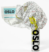
Oslo Crumpled City Map

Olso Crumpled City Map from a collection of street plans of major cities printed on soft, very lightweight (approximately only 20g) and yet extremely tear-resistant and 100% waterproof material, specifically designed to be scrunched and crammed into pockets, handbags and backpacks, either on its own or in the pouch from the same material provided with each map. Creases are a fully intentional part of the quirkiness of the Crumpled City maps – the more battered they are they better they look.Parks and other green spaces are highlighted, as are metro stations, and important buildings are named. Each map also highlights 10 recommended “soulsights”, imaginatively chosen to present the essence of each city rather than the most obvious tourist destinations. The accompanying index
placed next to the map lists locations of tourist interest: selected streets and squares, monuments and historical places, museums and galleries, parks, etc. Whilst cartographically these Crumpled City maps provide perhaps not the most precise representation of the street network, they are handy for sightseeing, light and durable, can be used as a table cloth when picnicking in the Luxembourg Gardens, Hyde Park, the Retiro or the Central Park, or just as an unusual decoration… Selected cities are also presented on more colourful ‘junior’ maps, specially designed for children. Drawings highlight not only important buildings and famous locations but also places which will specifically appeal to children: toy shops, bookshops, best ice cream, etc. Each title has a list of
the recommended not-to-be missed locations with addresses and, where available, websites.To see the full list of cities covered by this unique series please click on the series link.
RIP - This product is no longer available on our network. It was last seen on 25.09.2019

This page now acts as a permanent archive for this product. Add more information using the comments box below to ensure it can still be found by future generations.

Use our search facility to see if it is available from an alternative contributor.
  • Availability: Out Of Stock
  • Supplier: Stanfords
  • SKU: 9788897487012
Availability: In Stock
£10.00

Product Description

Olso Crumpled City Map from a collection of street plans of major cities printed on soft, very lightweight (approximately only 20g) & yet extremely tear-resistant & 100% waterproof material, specifically designed to be scrunched & crammed into pockets, handbags & backpacks, either on its own or in the pouch from the same material provided with each map. Creases are a fully intentional part of the quirkiness of the Crumpled City maps – the more battered they are they better they look. Parks & other green spaces are highlighted, as are metro stations, & important buildings are named. Each map also highlights 10 recommended “soulsights”, imaginatively chosen to present the essence of each city rather than the most obvious tourist destinations. The accompanying index placed next to the map lists locations of tourist interest: selected streets & squares, monuments & historical places, museums & galleries, parks, etc. Whilst cartographically these Crumpled City maps provide perhaps not the most precise representation of the street network, they are handy for sightseeing, light & durable, can be used as a table cloth when picnicking in the Luxembourg Gardens, Hyde Park, the Retiro or the Central Park, or just as an unusual decoration… Selected cities are also presented on more colourful ‘junior’ maps, specially designed for children. Drawings highlight not only important buildings & famous locations but also places which will specifically appeal to children: toy shops, bookshops, best ice cream, etc. Each title has a list of the recommended not-to-be missed locations with addresses &, where available, websites. To see the full list of cities covered by this unique series please click on the series link.

Reviews/Comments

Add New

Intelligent Comparison

Oooops!
We couldn't find anything!
Perhaps this product's unique.... Or perhaps we are still looking for comparisons!
Click to bump this page and we'll hurry up.

Price History

Vouchers

No voucher codes found.
Do you know a voucher code for this product or supplier? Add it to Insights for others to use.

Facebook

Jargon Buster

Ice - Frozen water, the solid state of water.
Toy - A generic term for something that can be played with for enjoyment
Pockets - A small bag to carry items usually sewn on the side of garments
soft - A descriptive word for an item/sound which is gentle to the touch or ears
Waterproof - Resistant to water, usualy specified by depth in metres
Network - A link and communication between things. Often computers or people.
Ice - Frozen water, Ice is cold to the touch and forms when water reaches 0 degrees centigrade.
Unusual - Something unique and different.
Resistant - Something that can repel against something.
Precise - A measurement on the accuracy of something
Children - A young life form within the early stages of physical development,
Cream - A warmer tone of white, also a thick white/yellow food liquid used in cooking.

Supplier Information

Stanfords
Stanfords was established in 1853 and opened their iconic Covent Garden flagship store in 1901. They have become the top retailer of maps, travel books and accessories in the UK and arguably offer the largest selection of maps and travel books worldwide. Famous names such as Captain Robert Falcon Scott, Ranulph Fiennes and Michael Palin have purchased from Stanfords. They now have a shop in Bristol and both stores together with other venues operate a calendar of events including talks, book signings and exhibitions. As a specialist map retailer, the map selection is comprehensive and includes road maps, street maps and walking maps from worldwide destinations, as well as a selection of world atlases and wall maps. Books include travel guides and travel literature. Stanfords also stock globes, from miniatures made of blue marble to magnificent floor-standing globes. The website features a selection of interesting articles on travel topics.
Page Updated: 2023-11-12 20:15:36

Community Generated Product Tags

Oh No! The productWIKI community hasn't generated any tags for this product yet!
Menu