
 United Kingdom
 France
 Germany
 Netherlands
 Sweden
 USA
USA
 Italy
Italy
 Spain
Spain
More From Contributor


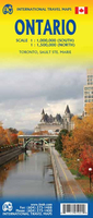
Ontario ITMB
Double-sided map of Ontario from the Vancouver-based ITMB with topography presented by altitude colouring rather than by relief shading, plus three plans of Toronto at different scales: the conurbation, central districts, plus The Beaches. On one side, the more densely populated eastern Ontario is shown at 1:1, 000, 000, with coverage extending from the Quebec border westwards beyond Sudbury to Manitoulin Island and within US to Detroit and Toledo; northwards coverage extends beyond the Ottawa River and the Trans-Canada Highway 17 to include Lake Temagami. The map shows the region’s road network on a base with altitude colouring (bands and spot heights in feet) and highlighting for national/provincial parks. Road distances are shown on main routes, and border crossings to the US
are indicated. Railway lines are includes and local airports are marked. Symbols indicate various places of interest and facilities, including campsites.The map of eastern Ontario is accompanied by three panels covering Toronto: a detailed street plan of the city’s central districts including the University of Toronto campus at 1:12, 500 showing its transport network and highlighting numerous facilities and places of interest; The Beaches district east of the downtown area; plus a road map of the Toronto conurbation including access to the Pearson International Airport.On the reverse western Ontario, with the good overlap between the sides, is covered at 1:1, 550, 000 with similar cartography and presentation. Coverage extends to approx. 90 º north; the Sault Ste. Marie region is
presented on a separate panel at 1:670, 000 approx. Both sides have separate indexes and show latitude and longitude lines at 1º intervals.To see other titles in this series please click on the series link.

Product Description
Reviews/Comments
Add New
Vouchers
No voucher codes found.
Do you know a voucher code for this product or supplier? Add it to Insights for others to use.
Do you know a voucher code for this product or supplier? Add it to Insights for others to use.
 Denmark