More From Contributor

£4.99
Six types of road are detailed, from primary roads to simple tracks. Altitude colouring (different colours depending upon height of the land) is used to show clearly the topography of the area. Campsites, caravan sites, mountain rescue stations, pony trekking centres, golf courses are clearly marked & a selection of places of interest are described in more detail along the bottom of the map. Indexed. ...
Archived Product
£6.99
As well as many great sea lochs, tumbling rivers & iconic mountains, Oban & North Argyll also boasts ancient, wildlife-rich woodlands & several fine gardens. Add to this the Crinan Canal, often described as `the most beautiful shortcut in Scotland`, & some of the most important historical & archaeological sites in the country & you have all the makings of a fascinating walking destination. From the harbourside bustle of Oban to the ancient peace of Kilmartin Glen, this guide features 40 walks over varied landscapes that take in the very best the ` Coastland of the Gaels` has to offer. ...
Archived Product
£6.39
A detailed topographic map of Oban, Kerrera & Loch Melfort from the Ordnance Survey Explorer series, covering The Garvellachs. Edition A1; Publication date January 2007 About this series: These highly detailed maps show all the administrative boundaries, settlements as small as isolated farms, the road network down to unfenced roads & country tracks, & field boundaries (hedges & drystone walls) which make navigation across the countryside much easier. Steep gradients on roads are indicated. Various landmarks, e.g. powerlines, archaeological sites, windmills, churches & lighthouses are shown & additional graphics indicate natural terrain features such as cliffs, scree, mud & vegetation variations. The contour interval is 5 metres in the lower parts of the country & 10 metres in the uplands, & spot heights are marked. Each map covers an area of 30 x 20km (i.e. approx. 19 x 12 miles), with some double-sided maps covering more, as indicated in the individual descriptions. The maps are fully GPS compatible, with the National Grid shown at 1km intervals & latitude & longitude indicated by margin ticks at 1'. The Explorer series has replaced the earlier, green-cover Pathfinder maps. The Explorer series is now complete & covers all of Engl&, Wales & Scotl&. Some sheets for popular areas like the National Parks are still branded as Outdoor Leisure (OL) maps, but are now included in this series as the cartography is the same as that in the Explorer Maps. The Explorer maps offer a substantial improvement on the Pathfinder series, with greater use of colour, larger area per map, & stronger emphasis on information for ramblers & tourists. This series is ideal for walking & other outdoor pursuits & each map shows a large amount of information for ramblers & tourists. Public rights of way are shown (except in Scotland), together with other routes with public access: National Trails & Recreational Paths, permitted paths & bridleways, & selected cycle routes. Open access land created under the Countryside & Rights of Way Act 2000 is marked. Tourist information

Includes::
caravan & camp sites, Park & Ride locations, recreation/leisure/sport centres, museums, historic buildings, English Heritage & National Trust sites, rural pubs, etc. The map legend is in English only, except for the tourist information content which is also in French & German.

...
Archived Product
£11.19
Laminated waterproof edition of a detailed topographic map of Oban, Kerrera & Loch Melfort from the Ordnance Survey Explorer series, covering The Garvellachs. Edition A1; Publication date January 2007 About this series: These highly detailed maps show all the administrative boundaries, settlements as small as isolated farms, the road network down to unfenced roads & country tracks, & field boundaries (hedges & drystone walls) which make navigation across the countryside much easier. Steep gradients on roads are indicated. Various landmarks, e.g. powerlines, archaeological sites, windmills, churches & lighthouses are shown & additional graphics indicate natural terrain features such as cliffs, scree, mud & vegetation variations. The contour interval is 5 metres in the lower parts of the country & 10 metres in the uplands, & spot heights are marked. Each map covers an area of 30 x 20km (i.e. approx. 19 x 12 miles), with some double-sided maps covering more, as indicated in the individual descriptions. The maps are fully GPS compatible, with the National Grid shown at 1km intervals & latitude & longitude indicated by margin ticks at 1'. The Explorer series has replaced the earlier, green-cover Pathfinder maps. The Explorer series is now complete & covers all of Engl&, Wales & Scotl&. Some sheets for popular areas like the National Parks are still branded as Outdoor Leisure (OL) maps, but are now included in this series as the cartography is the same as that in the Explorer Maps. The Explorer maps offer a substantial improvement on the Pathfinder series, with greater use of colour, larger area per map, & stronger emphasis on information for ramblers & tourists. This series is ideal for walking & other outdoor pursuits & each map shows a large amount of information for ramblers & tourists. Public rights of way are shown (except in Scotland), together with other routes with public access: National Trails & Recreational Paths, permitted paths & bridleways, & selected cycle routes. Open access land created under the Countryside & Rights of Way Act 2000 is marked. Tourist information

Includes::
caravan & camp sites, Park & Ride locations, recreation/leisure/sport centres, museums, historic buildings, English Heritage & National Trust sites, rural pubs, etc. The map legend is in English only, except for the tourist information content which is also in French & German.

...
Archived Product
£5.99
Oban to Campbeltown Cycle Route at 1:100, 000 in a series of cycling maps from Sustrans, the charity behind developing UK’s National Cycle Network. The map is printed on light waterproof & tear-resistant synthetic paper & presents Route No. 78 on four panels with several suggestions for day rides. Each title in the Sustrans series of cycling maps covers either a single route, presented in sections on separate strip maps, or a wider area with the main cycling route (s) prominently highlighted but other recommendations for cyclists also marked. The area covered each map is shown on our website on its individual “coverage” image. The route has markers indicating steep gradients, controlled access, distances & possible danger points. Route profiles indicate riding surface & the density of traffic (main road, minor road & traffic-free) &, where appropriate, street plans show the course of the route across towns & cities. On maps covering a wider area around the main National Cycle Route suggestions of possible day ride excursions are also marked. A range of symbols highlight various facilities & places of interest, including tourist information centres, youth hostels, cafes & pubs, grocery shops, cycle shops & hire, historical & natural sites, etc. For access by rail, the rail network is shown with stations &, where appropriate, metro stations are also marked. Topography is shows by altitude colouring. Unless specifically indicated in the individual description, the maps do not show British National Grid lines for GPS. Each title also contains contact addresses for various useful organizations, etc. Many titles are printed on light, waterproof & tear-resistant synthetic paper. ...
Archived Product
£14.99
Oban, Kerrera & Loch Melfor area on a detailed topographic & GPS compatible map No. 359, waterproof version, from the Ordnance Survey’s 1:25, 000 Explorer series.MOBILE DOWNLOADS: this title & all the other OS Explorer maps include a code for downloading after purchase the digital version onto your smartphone or tablet for viewing on the OS smartphone app.OS EXPLORER SERIES: to see the list of all the titles in the OS Explorer series, both paper & waterproof versions, please click on the series link. The Explorer series, Ordnance Survey’s most detailed maps recommended for anyone enjoying outdoor activities, provides topographic coverage of Great Britain at 1:25, 000 on GPS compatible maps with hiking trails, cycling routes & extensive tourist information. Each printed map is available either on paper or as a waterproof & tear-resistant OS Active Map, as indicated in its title. Britain’s National Parks & other areas of particular tourist interest are presented on often double-sided OL (Outdoor Leisure) maps, whilst most standard format Explorers cover an area of 30 x 20km (approx. 19 x 12 miles). All three versions (paper, waterproof & digital) are the same & provide plenty of recreational & tourist information, indicating the traditional public right of way paths (except in Scotland where different laws apply), including bridleways & byways. National Trails & other long-distance paths are marked, as well as permissive footpaths or bridleways & on-road or traffic-free cycle routes with, where appropriate, their National/ Regional Cycle Network numbers. Boundaries of access land are clearly marked. A wide range of symbols provides additional tourist information, highlighting camping & caravanning sites, information offices & visitors’ centres, parking & picnicking places, country pubs, sport & recreational facilities including cycle hire locations & mountain biking trails, historic buildings & museums, etc. Exceptionally clear presentation of the landscape is provided by contours at 5m or in the uplands at 10m intervals, with additional spot heights plus colouring and/or graphics for different types of woodlands, orchards, heath, marshl&, scree or boulders, & other topographic features. For GPS users the maps have British National Grid lines at 1km intervals, with latitude & longitude given by margin ticks at 1`. Clearly laid out map legend

Includes::
French & German translations for the tourist information symbols.

...
Archived Product
£8.99
Oban, Kerrera & Loch Melfor area on a detailed topographic & GPS compatible map No. 359, paper version, from the Ordnance Survey’s 1:25, 000 Explorer series.MOBILE DOWNLOADS: this title & all the other OS Explorer maps include a code for downloading after purchase the digital version onto your smartphone or tablet for viewing on the OS smartphone app.OS EXPLORER SERIES: to see the list of all the titles in the OS Explorer series, both paper & waterproof versions, please click on the series link. The Explorer series, Ordnance Survey’s most detailed maps recommended for anyone enjoying outdoor activities, provides topographic coverage of Great Britain at 1:25, 000 on GPS compatible maps with hiking trails, cycling routes & extensive tourist information. Each printed map is available either on paper or as a waterproof & tear-resistant OS Active Map, as indicated in its title. Britain’s National Parks & other areas of particular tourist interest are presented on often double-sided OL (Outdoor Leisure) maps, whilst most standard format Explorers cover an area of 30 x 20km (approx. 19 x 12 miles). All three versions (paper, waterproof & digital) are the same & provide plenty of recreational & tourist information, indicating the traditional public right of way paths (except in Scotland where different laws apply), including bridleways & byways. National Trails & other long-distance paths are marked, as well as permissive footpaths or bridleways & on-road or traffic-free cycle routes with, where appropriate, their National/ Regional Cycle Network numbers. Boundaries of access land are clearly marked. A wide range of symbols provides additional tourist information, highlighting camping & caravanning sites, information offices & visitors’ centres, parking & picnicking places, country pubs, sport & recreational facilities including cycle hire locations & mountain biking trails, historic buildings & museums, etc. Exceptionally clear presentation of the landscape is provided by contours at 5m or in the uplands at 10m intervals, with additional spot heights plus colouring and/or graphics for different types of woodlands, orchards, heath, marshl&, scree or boulders, & other topographic features. For GPS users the maps have British National Grid lines at 1km intervals, with latitude & longitude given by margin ticks at 1`. Clearly laid out map legend

Includes::
French & German translations for the tourist information symbols.

...
Archived Product
£5.99
Oban, Kintyre & the Trossachs Cycle Map at 1:110, 000 from Sustrans, including the Caledonia Way, plus two day rides: Oban Circuit & Loch Katrine Loop. Street plans show Oban, Campbeltown, Lochgilphead, & Tarbert. Maps is this Sustrans series show all the National & Regional Cycle Network routes clearly numbered & have the colouring distinguishing between the on-road & traffic-free sections. The publishers’ own recommendations are shown in contrasting colour &, in most titles, are in addition presented on the reverse side on separate panels where each circuit is annotated with useful notes. The maps have contours & altitude colouring to show the topography, with additional gradient markings. Towns along the routes are annotated with symbols indicating what facilities can be found there. Also marked are various places of interest, on or near the routes, & railway lines are shown with stations for access to the routes by rail. On the reverse each title also provides large, clear city centre street plans of main towns, highlighting the Cycle Network and/or the recommended routes. Also included are contact details of tourist information centres. To see the list of titles in this series please click on the series link. ...
Archived Product
£12.99
The rock of Dunadd, a few miles north of Lochgilphead, marks the place where the Scots established their headquarters after landing from Ireland around 500AD, & it can rightfully claim to be the birthplace of Scotl&. It is also at the heart of present-day Argyll, which roughly corresponds to the area covered by this guide. There are a range of routes across different terrains, including a walk around the Isle of Iona, with its wealth of ancient monuments, superb beaches & an ascent up Ben More, the highest peak on Mull. ...
Archived Product
£11.99
Oban, Mull & Kintyre in the Pathfinder Guides series, produced in association with Ordnance Survey & published by Crimson; comprising a range of walking guides to popular British destinations. Each Pathfinder guide

Includes::
28 varied walks ranging from easy strolls to exhilarating hikes & is accompanied by 1:25, 000 Ordnance Survey mapping with marked, colour-coded routes. Introductory sections profile the county or region covered, with recommendations on the best time to visit & a brief explanation of GPS. An ‘at-a-glance’ table gives an overview of the walks covered in the guide, with information on the starting point, National Grid reference, distance, time, highest point & general brief comments. Each walk described in the guide has a dedicated information box profiling the walk, with useful information such as the starting point, distance, approximate time, parking, refreshments & the relevant Ordnance Survey map for navigation. Clear & easy to follow directions are provided & are accompanied by practical information about the route, including the location of toilets, refreshment areas & picnic sites, as well as colour photography illustrating some of the highlights of the walk. A Further Information section contains information on walking safety & responsible walking, as well as a list of useful contacts.

...
Archived Product

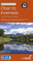
Oban To Inverness Cycle Route Map

This map covers National Route 78 from Oban to Inverness passing through Fort William, Fort Augustus and along the shore of Loch Ness. It is recommended to take at least three days to cycle this 115-mile route. This is the northern half of The Caledonia Way cycle route - a 237-mile tour from Campbeltown to Inverness.This full colour map based on Ordnance Survey data shows clearly mapped cycle routes on traffic-free paths, quiet lanes and roads, with easy to read contours and route profile.Also features:- Detailed inset maps for the major towns and cities- Ferry information- Local Visitor Information Centres- Cycle hire and repair shops- Transport links- Campsites
RIP - This product is no longer available on our network. It was last seen on 25.09.2019

This page now acts as a permanent archive for this product. Add more information using the comments box below to ensure it can still be found by future generations.

Use our search facility to see if it is available from an alternative contributor.
  • Availability: Out Of Stock
  • Supplier: Stanfords
  • SKU: 9781910845196
Availability: In Stock
£8.99

Product Description

This map covers National Route 78 from Oban to Inverness passing through Fort William, Fort Augustus & along the shore of Loch Ness. It is recommended to take at least three days to cycle this 115-mile route. This is the northern half of The Caledonia Way cycle route
- a 237-mile tour from Campbeltown to Inverness. This full colour map based on Ordnance Survey data shows clearly mapped cycle routes on traffic-free paths, quiet lanes & roads, with easy to read contours & route profile. Also

Features:
- Detailed inset maps for the major towns & cities- Ferry information- Local Visitor Information Centres- Cycle hire & repair shops- Transport links- Campsites

Reviews/Comments

Add New

Intelligent Comparison

Oooops!
We couldn't find anything!
Perhaps this product's unique.... Or perhaps we are still looking for comparisons!
Click to bump this page and we'll hurry up.

Price History

Vouchers

No voucher codes found.
Do you know a voucher code for this product or supplier? Add it to Insights for others to use.

Facebook

Jargon Buster

Colour - The categorised spectrum of light visable to humans
Transport - Something that carries people or goods.

Supplier Information

Stanfords
Stanfords was established in 1853 and opened their iconic Covent Garden flagship store in 1901. They have become the top retailer of maps, travel books and accessories in the UK and arguably offer the largest selection of maps and travel books worldwide. Famous names such as Captain Robert Falcon Scott, Ranulph Fiennes and Michael Palin have purchased from Stanfords. They now have a shop in Bristol and both stores together with other venues operate a calendar of events including talks, book signings and exhibitions. As a specialist map retailer, the map selection is comprehensive and includes road maps, street maps and walking maps from worldwide destinations, as well as a selection of world atlases and wall maps. Books include travel guides and travel literature. Stanfords also stock globes, from miniatures made of blue marble to magnificent floor-standing globes. The website features a selection of interesting articles on travel topics.
Page Updated: 2023-11-12 20:15:36

Community Generated Product Tags

Oh No! The productWIKI community hasn't generated any tags for this product yet!
Menu