More From Contributor

£28.00
Nopi: The Cookbook

Includes::
over 120 of the most popular dishes from Yotam`s innovative Soho-based restaurant

...
Archived Product
£6.99
Norbert the penguin lives in Antarctica. He dreams of being a big star & singing & dancing for millions of people! One day he leaves his home & makes the long journey to the big city. He works hard & before long he is the most famous penguin the world has ever known! But Norbert is lonely too. Can he go back to his family without giving up the thing he loves to do? A beautiful picture book from the writer & illustrator of Oh no! Where did Walter Go? ...
Archived Product
£3.50
Norbury & Upper Norwood in 1894 in a fascinating series of reproductions of old Ordnance Survey plans in the Alan Godfrey Editions, ideal for anyone interested in the history of their neighbourhood or family. The map covers an area stretching from London Road & Norbury station eastward to Spa Hill at Upper Norwood, & from Gibsons Hill southward to Beulah Road North & the tip of Thornton Heath. A major feature is the Beulah Brick Works, other features include the Beulah Spa with chalybeate spring, villas on Beulah Hill, Hermitage Sports Grounds, Norbury Hall. Extracts from Croydon & Norwood directories cover Beulah Hill, Moffat Road, Osborne Road, Spa Hill & Spa Road. About the Alan Godfrey Editions of the 25” OS Series: Selected towns in Great Britain & Ireland are covered by maps showing the extent of urban development in the last decades of the 19th & early 20th century. The plans have been taken from the Ordnance Survey mapping & reprinted at about 15 inches to one mile (1:4, 340). On the reverse most maps have historical notes & many also include extracts from contemporary directories. Most maps cover about one mile (1.6kms) north/south, one & a half miles (2.4kms) across; adjoining sheets can be combined to provide wider coverage.FOR MORE INFORMATION & A COMPLETE LIST OF ALL AVAILABLE TITLES PLEASE CLICK ON THE SERIES LINK. ...
Archived Product
£16.99
Nord
- Pas de Calais
- Picardie Guide Vert *FRENCH Edition* in Michelin’s Green Guide series covering France, with all the

...
Archived Product
£5.99
The départment of Nord at 1:150, 000 in Michelin’s Local Series of France, with highlighting for scenic routes, an index, a special panel with best sights & recommended driving tours, & a street plan of Lille. Coverage extends from the ferry terminal at Calais (the whole town is not included) & Dunkerque to Brussels & Ghent in the north-east, & Amiens & St-Quintin in the south. PLEASE NOTE: our coverage image, provided by the publishers, does not take into account which areas along the edge of the map are blocked by the index & the additional features. Maps in Michelin’s Local Series of France have the same cartography (road network & place names shown on the maps) as the publishers’ Regional Series at 1;200, 000 but enlarged here to 1:150, 000 to provide greater clarity & larger, easier to read print size. Road network is presented in great detail, indicating width, motorway services & rest areas, dangerous or restricted entry roads, steep gradients, height & weight restrictions, etc. Scenic sections are highlighted. The maps also show selected cycle paths & nature trails. Railway lines are shown with stations & local airports are marked. Symbols indicate various places of interest, with additional star rating for best sights, based on the publishers’ Green Guides for French regions. Satellite-derived base with colouring for the forested areas & boundaries of national or regional parks shows the topography. In the mountainous regions the maps have bold, very effective relief shading, with a large number of names of peaks, passes, & other topographic features. The maps have latitude & longitude lines at 10’ intervals & are indexed. Map legend

Includes::
English. Each title in addition

Includes::
a panel showing the area’s principal roads & places of interest, plus recommendations for sightseeing tours. Also provided are town centre maps of main cities, indicating principal traffic arteries, one way streets & places of interest. Only selected streets are named & listed in the accompanying index. Please click on the series link to see all the titles in this series.


...
Archived Product
£17.99
One of the titles in a series of topographic maps with contours at 100m intervals. Physical features shown include moraine, rocks, coastline with flat foreshore, etc. The maps also show settlements, roads, mines, cabins, radio stations, aerial cableways, airfields, etc. National park & nature reserve boundaries are marked. The maps have a UTM grid & lines of longitude & latitude shown at 1° & 30` intervals respectively. The map was originally published in 1987; the map legend also

Includes::
English.

...
Archived Product
£8.50
Nordeney (No.729), a detailed, GPS compatible map at 1:17, 500 from Kompass with local & long-distance footpaths, cycling routes, accommodation, etc, printed on durable, waterproof & tear-resistant synthetic paper.KOMPASS HIKING & RECREATIONAL MAPS: This title is part of an extensive series covering Austria, much of Germany & the Slovenian Alps. Kompass are Europe’s largest publishers of hiking maps; their mapping of other countries, including expanding coverage of Italy, is listed on our website separately.CARTOGRAPHY: The maps are contoured with additional shading, graphic relief & colouring to provide a more detailed picture of the terrain, vegetation and/or land use. Contour interval varies from 10m in the coastal areas of Northern Germany to 40 or 50 metres in the mountainous regions. All the maps highlight local & long-distance waymarked footpaths, including climbing trails. Most titles also show cycling routes, mountain bike trails, &, the in mountainous areas, ski routes. The maps indicate various types of accommodation (selected inns & hotels, youth hostels, campsites, mountain refuges), as well as recreational facilities, places of interest, etc. Latest editions also show access by public transport with bus stops and/or Park+ Ride facilities.GEOGRAPHICAL COORDINATES: Unless indicated to the contrary in the individual description, the maps have a UTM grid for GPS users. MAP LEGEND: Most maps now include full English legend, particularly titles covering the Alpine areas. Some maps covering mainly eastern Austria or the less popular parts of Germany may still have a legend in German only.OTHER
Features: Selected titles include on the reverse panorama drawings of their area with names of villages, peaks, valleys, etc. and/or have a booklet with pictures of local wild flowers with their Latin names. Many titles are now published as competitively priced sets of two or more maps, offering a wider coverage.BOOKLETS: PLEASE NOTE BEFORE ORDERING! Many titles come with a booklet describing the area and/or various hiking routes. Unless indicated in the individual description that the booklet

Includes::
English, these booklets are IN GERMAN only. The booklets are not necessary to use the maps since, as stated above, full English language map legend is provided.


...
Archived Product
£17.99
Detailed topographic map of Nordenskiöld L&, the central part of Spitsbergen, which

Includes::
the main town

...
Archived Product
£17.99
One of the titles in the topographic survey of the Svalbard group still published only in a black & white version, without geographical names. These maps cover parts of the northern & north-eastern Spitzbergen, Nordaustlandet, Edgeøya & some of the small islands. The western coast, central & southern part of Spitzbergen, plus two small islands of Svenskøya & Kongsøyaare are now available in colour versions, with contours at 25-metre intervals, bold relief shading & spot heights. The maps settlements, roads & tracks, working & disused mines, airfields, lighthouses & radio beacons, etc. A grid gives UTM co-ordinates plus latitude in steps of 10` & longitude in 20’. ...
Archived Product
£16.99
Launched in 2007, the Nordic Bakery is a peaceful haven in the heart of London's bustling West End. Their products reflect the wholesome but comforting style of baking in Scandinavia. The emphasis is on fresh, seasonal produce & healthier baking ingredients, such as rye flour, oats & barley. The rustic but modern menu

Includes::
open rye-bread sandwiches, cakes & cinnamon buns. The Nordic Bakery Cookbook means that you can bake your own Bread, such as the popular rye bread, Savoury Pastries, Cakes, Sweet Buns, Desserts & Biscuits in your own home.

...
Archived Product

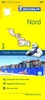
Nord-Pas-de-Calais - Picardy Michelin Regional Map 511

French administrative region of Nord - Pas-de-Calais - Picardie at 1:200, 000 in a series of double-sided touring maps from Michelin. The map includes city centre street plans of Lille and Amiens indicating principal traffic arteries, one way streets and places of interest, with selected streets named and listed in the accompanying index.Maps in the Michelin’s REGIONAL series are designed to cover a large area in each title and offer a more convenient touring alternative to the publishers’ LOCAL coverage of France at 1:150, 000. The maps present the road network in great detail, indicating width and the number of lanes, motorway services and rest areas, dangerous or restricted entry roads, steep gradients, height and weight restrictions, etc. Scenic sections are highlighted.
The maps also show selected cycle paths and nature trails. Railway lines are shown with stations and local airports are marked. Satellite-derived base with colouring for the forested areas and boundaries of national or regional parks shows the topography. In the mountainous regions the maps have bold, very effective relief shading, with a large number of names of peaks, passes, and other topographic features. The maps have latitude and longitude lines at 10’ intervals and are indexed. Map legend includes English.To see the list of all the regional titles in this series please click on the series link.
RIP - This product is no longer available on our network. It was last seen on 25.09.2019

This page now acts as a permanent archive for this product. Add more information using the comments box below to ensure it can still be found by future generations.

Use our search facility to see if it is available from an alternative contributor.
  • Availability: Out Of Stock
  • Supplier: Stanfords
  • SKU: 9782067209589
Availability: In Stock
£5.99

Product Description

French administrative region of Nord
- Pas-de-Calais
- Picardie at 1:200, 000 in a series of double-sided touring maps from Michelin. The map

Includes::
city centre street plans of Lille & Amiens indicating principal traffic arteries, one way streets & places of interest, with selected streets named & listed in the accompanying index. Maps in the Michelin’s REGIONAL series are designed to cover a large area in each title & offer a more convenient touring alternative to the publishers’ LOCAL coverage of France at 1:150, 000. The maps present the road network in great detail, indicating width & the number of lanes, motorway services & rest areas, dangerous or restricted entry roads, steep gradients, height & weight restrictions, etc. Scenic sections are highlighted. The maps also show selected cycle paths & nature trails. Railway lines are shown with stations & local airports are marked. Satellite-derived base with colouring for the forested areas & boundaries of national or regional parks shows the topography. In the mountainous regions the maps have bold, very effective relief shading, with a large number of names of peaks, passes, & other topographic features. The maps have latitude & longitude lines at 10’ intervals & are indexed. Map legend

Includes::
English. To see the list of all the regional titles in this series please click on the series link.

Reviews/Comments

Add New

Intelligent Comparison

Oooops!
We couldn't find anything!
Perhaps this product's unique.... Or perhaps we are still looking for comparisons!
Click to bump this page and we'll hurry up.

Price History

Vouchers

No voucher codes found.
Do you know a voucher code for this product or supplier? Add it to Insights for others to use.

Facebook

Jargon Buster

France - A state situated in Western Europe with several overseas territories.
weight - A measure of the force applied on an object by gravity. Measured metric in grams and kilos or imperial in lbs and oz
Weight - a measurement of how heavy an object appears due to the pull of gravity. For example the weight of an object on planet earth will be different to the weight of the object on the moon
Network - A link and communication between things. Often computers or people.
Large - something that takes up more space than normal.
Road - a manmade lane or a path that is used to speed up travel.
Alternative - Another available choice or possibility
Width - The measurement of something from one side to the other.
Regional - An adjective to describe a set geographic area.
Convenient - Something that suits and fits well to other activities.

Supplier Information

Stanfords
Stanfords was established in 1853 and opened their iconic Covent Garden flagship store in 1901. They have become the top retailer of maps, travel books and accessories in the UK and arguably offer the largest selection of maps and travel books worldwide. Famous names such as Captain Robert Falcon Scott, Ranulph Fiennes and Michael Palin have purchased from Stanfords. They now have a shop in Bristol and both stores together with other venues operate a calendar of events including talks, book signings and exhibitions. As a specialist map retailer, the map selection is comprehensive and includes road maps, street maps and walking maps from worldwide destinations, as well as a selection of world atlases and wall maps. Books include travel guides and travel literature. Stanfords also stock globes, from miniatures made of blue marble to magnificent floor-standing globes. The website features a selection of interesting articles on travel topics.
Page Updated: 2023-11-12 20:15:36

Community Generated Product Tags

Oh No! The productWIKI community hasn't generated any tags for this product yet!
Menu