More From Contributor
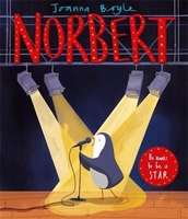
£12.99
Vasantha is a van driver in Sri Lanka. After nearly three decades of conflict, the civil war is over & the country is moving tentatively into the future
- though at times the recent past seems too close for comfort. Entrepreneurial hoteliers have mysterious scars under their collars; Chinese businessmen looking to invest in scrap metal are led to gigantic scrapyards of abandoned bicycles; genial old soldiers are headhunted for brutal war crimes; young Sinhalese men pine after Tamil girls whose brothers, in another time, died by their hands. In this collection of linked stories, Vasantha drives across the beautiful but scarred landscape of his home isl&, lingering on the periphery of his passengers` varied stories. Though he keeps his own counsel & remains stoically in the background, he cannot help but reveal a little something of his own story too.
...
Archived Product
£8.99
Vasantha is a van driver for hire, ferrying aid workers, returning exiles, & tentative entrepreneurs across the battle-scarred landscapes of Sri Lanka. The civil war is finally over, but the traumas of the past are still haunting. Behind the facade of peace we are made to remember the war: mysterious hoteliers conceal scars under their collars; genial old soldiers are secretly identified as perpetrators of brutal crimes; young Sinhalese men pine after Tamil girls whose brothers died by their hands. Vasantha keeps his own counsel, lingering on the periphery of his passengers` stories, but as time goes on he reveals a little of his own story too. Perceptive, sombre & finely-tuned, Noontide Toll paints an extraordinary portrait of a post-war Sri Lanka grappling with the ghosts of its troubled past. ...
Archived Product
£9.50
Topographical survey of Belgium at 1:20, 000 from Nationaal Geografisch Instituut / Institut Géographique National, the country’s national survey organization. Each 20K map covers one quarter of the corresponding 1:50, 000 map (with adjustments in the border & coastal areas). The maps provide all the information expected of topographic mapping at this scale & in addition have an unusually large amount of vegetation and/or land use information (different types of woodlands, gardens, orchards, heath, etc). The maps have a 1-km UTM grid, with margin ticks for latitude & longitude at intervals of 1`. Map legend & a glossary of terms used on the maps include English. Stanfords keeps as regular stock 20K maps for the World War I battlefields around the Ypres, Messines & Passchendaele, & for the area of the Battle of Waterloo. The 1:20, 000 survey covers the whole of Belgium & maps for other regions can be supplied as special orders. To see the list of titles in this series please click on the series link.PLEASE NOTE: the Long-Distance Footpaths Map of Belgium at 1:300, 000 which shows the division of Belgium into the 50K survey sheets can also be used to see in more detail coverage by the 20K maps. ...
Archived Product
£17.99
The 1:50, 000 topographic map gives a more general picture of the ground features than a basic map. It shows settlements, houses, roads, cultivated areas, waterways, cutting areas, mires, rock exposures, & relief. One map sheet covers an area of 30 x 40 km & one centimetre corresponds to 500 metres on the ground. The 1:50, 000 topographic map is also an ideal complement to nautical charts as it provides useful information about the land areas adjacent to waterways. For example, all Finnish sea areas are covered by 1:50, 000 topographic map sheets. ...
Archived Product
£28.00
Nopi: The Cookbook

Includes::
over 120 of the most popular dishes from Yotam`s innovative Soho-based restaurant

...
Archived Product
£3.50
Norbury & Upper Norwood in 1894 in a fascinating series of reproductions of old Ordnance Survey plans in the Alan Godfrey Editions, ideal for anyone interested in the history of their neighbourhood or family. The map covers an area stretching from London Road & Norbury station eastward to Spa Hill at Upper Norwood, & from Gibsons Hill southward to Beulah Road North & the tip of Thornton Heath. A major feature is the Beulah Brick Works, other features include the Beulah Spa with chalybeate spring, villas on Beulah Hill, Hermitage Sports Grounds, Norbury Hall. Extracts from Croydon & Norwood directories cover Beulah Hill, Moffat Road, Osborne Road, Spa Hill & Spa Road. About the Alan Godfrey Editions of the 25” OS Series: Selected towns in Great Britain & Ireland are covered by maps showing the extent of urban development in the last decades of the 19th & early 20th century. The plans have been taken from the Ordnance Survey mapping & reprinted at about 15 inches to one mile (1:4, 340). On the reverse most maps have historical notes & many also include extracts from contemporary directories. Most maps cover about one mile (1.6kms) north/south, one & a half miles (2.4kms) across; adjoining sheets can be combined to provide wider coverage.FOR MORE INFORMATION & A COMPLETE LIST OF ALL AVAILABLE TITLES PLEASE CLICK ON THE SERIES LINK. ...
Archived Product
£16.99
Nord
- Pas de Calais
- Picardie Guide Vert *FRENCH Edition* in Michelin’s Green Guide series covering France, with all the

...
Archived Product
£5.99
The départment of Nord at 1:150, 000 in Michelin’s Local Series of France, with highlighting for scenic routes, an index, a special panel with best sights & recommended driving tours, & a street plan of Lille. Coverage extends from the ferry terminal at Calais (the whole town is not included) & Dunkerque to Brussels & Ghent in the north-east, & Amiens & St-Quintin in the south. PLEASE NOTE: our coverage image, provided by the publishers, does not take into account which areas along the edge of the map are blocked by the index & the additional features. Maps in Michelin’s Local Series of France have the same cartography (road network & place names shown on the maps) as the publishers’ Regional Series at 1;200, 000 but enlarged here to 1:150, 000 to provide greater clarity & larger, easier to read print size. Road network is presented in great detail, indicating width, motorway services & rest areas, dangerous or restricted entry roads, steep gradients, height & weight restrictions, etc. Scenic sections are highlighted. The maps also show selected cycle paths & nature trails. Railway lines are shown with stations & local airports are marked. Symbols indicate various places of interest, with additional star rating for best sights, based on the publishers’ Green Guides for French regions. Satellite-derived base with colouring for the forested areas & boundaries of national or regional parks shows the topography. In the mountainous regions the maps have bold, very effective relief shading, with a large number of names of peaks, passes, & other topographic features. The maps have latitude & longitude lines at 10’ intervals & are indexed. Map legend

Includes::
English. Each title in addition

Includes::
a panel showing the area’s principal roads & places of interest, plus recommendations for sightseeing tours. Also provided are town centre maps of main cities, indicating principal traffic arteries, one way streets & places of interest. Only selected streets are named & listed in the accompanying index. Please click on the series link to see all the titles in this series.


...
Archived Product
£5.99
French administrative region of Nord
- Pas-de-Calais
- Picardie at 1:200, 000 in a series of double-sided touring maps from

...
Archived Product
£17.99
One of the titles in a series of topographic maps with contours at 100m intervals. Physical features shown include moraine, rocks, coastline with flat foreshore, etc. The maps also show settlements, roads, mines, cabins, radio stations, aerial cableways, airfields, etc. National park & nature reserve boundaries are marked. The maps have a UTM grid & lines of longitude & latitude shown at 1° & 30` intervals respectively. The map was originally published in 1987; the map legend also

Includes::
English.

...
Archived Product

Norbert

Norbert the penguin lives in Antarctica. He dreams of being a big star and singing and dancing for millions of people! One day he leaves his home and makes the long journey to the big city. He works hard and before long he is the most famous penguin the world has ever known! But Norbert is lonely too. Can he go back to his family without giving up the thing he loves to do? A beautiful picture book from the writer and illustrator of Oh no! Where did Walter Go?
RIP - This product is no longer available on our network. It was last seen on 25.09.2019

This page now acts as a permanent archive for this product. Add more information using the comments box below to ensure it can still be found by future generations.

Use our search facility to see if it is available from an alternative contributor.
  • Availability: Out Of Stock
  • Supplier: Stanfords
  • SKU: 9781787412200
Availability: In Stock
£6.99

Product Description

Norbert the penguin lives in Antarctica. He dreams of being a big star & singing & dancing for millions of people! One day he leaves his home & makes the long journey to the big city. He works hard & before long he is the most famous penguin the world has ever known! But Norbert is lonely too. Can he go back to his family without giving up the thing he loves to do? A beautiful picture book from the writer & illustrator of Oh no! Where did Walter Go?

Reviews/Comments

Add New

Intelligent Comparison

Oooops!
We couldn't find anything!
Perhaps this product's unique.... Or perhaps we are still looking for comparisons!
Click to bump this page and we'll hurry up.

Price History

Vouchers

No voucher codes found.
Do you know a voucher code for this product or supplier? Add it to Insights for others to use.

Facebook

Jargon Buster

star - A giant ball of plasma held together by gravity.
World - A physical grouping, commonly used to describe earth and everything associated with ti
Day - The time it takes a planet or other space objects to complete one rotation.
Home - A place of permanent residence for families.
Family - A group of people that live together made up from parents and children.

Supplier Information

Stanfords
Stanfords was established in 1853 and opened their iconic Covent Garden flagship store in 1901. They have become the top retailer of maps, travel books and accessories in the UK and arguably offer the largest selection of maps and travel books worldwide. Famous names such as Captain Robert Falcon Scott, Ranulph Fiennes and Michael Palin have purchased from Stanfords. They now have a shop in Bristol and both stores together with other venues operate a calendar of events including talks, book signings and exhibitions. As a specialist map retailer, the map selection is comprehensive and includes road maps, street maps and walking maps from worldwide destinations, as well as a selection of world atlases and wall maps. Books include travel guides and travel literature. Stanfords also stock globes, from miniatures made of blue marble to magnificent floor-standing globes. The website features a selection of interesting articles on travel topics.
Page Updated: 2023-11-12 20:15:36

Community Generated Product Tags

Oh No! The productWIKI community hasn't generated any tags for this product yet!
Menu