More From Contributor

£8.99
In the early eighteenth century, a woman finds herself set adrift from a mutinous ship & cast ashore on a remote desert isl&. There she finds shelter with its only other inhabitants: a man named Cruso & his tongueless slave Friday. In time, she builds a life for herself as Cruso`s companion &, eventually, his lover. At last, they are rescued by a passing ship, but only she & Friday survive the journey back to London. Determined to have her story told, she pursues the eminent man of letters Daniel Foe in the hope that he will truthfully relate her memories to the world. But with Cruso dead, Friday incapable of speech & Foe himself intent on reshaping her narrative, Barton struggles to maintain her grip on the past, only to fall victim to the seduction & tyranny of storytelling itself. Treacherous, elegant & unexpectedly moving, Foe remains one of the most exquisitely composed of this pre-eminent author`s works. ...
Archived Product
£8.99
Nobel Laureate & two-time Booker prize-winning author of Disgrace & The Life & Times of Michael K, J M Coetzee reimagines Daniel De Foe`s classic novel Robinson Crusoe in Foe. Published as a Penguin Essential for the first time. In an act of breathtaking imagination, J M Coetzee radically reinvents the story of Robinson Crusoe. In the early eighteenth century, Susan Barton finds herself adrift from a mutinous ship & cast ashore on a remote desert isl&. There she finds shelter with its only other inhabitants: a man named Cruso & his tongueless slave, Friday. In time, she builds a life for herself as Cruso`s companion &, eventually, his lover. At last they are rescued by a passing ship, but only she & Friday survive the journey back to London. Determined to have her story told, she pursues the eminent man of letters Daniel Foe in the hope that he will relate truthfully her memories to the world. But with Cruso dead, Friday incapable of speech & Foe himself intent on reshaping her narrative, Barton struggles to maintain her grip on the past, only to fall victim to the seduction of storytelling itself. Treacherous, elegant & unexpectedly moving, Foe remains one of the most exquisitely composed of this pre-eminent author`s works. ”A small miracle of a book...of marvellous intricacy & overwhelming power.” (Washington Post). ”A superb novel.” (The New York Times). ...
Archived Product
£12.99
Foggia Province at 1:150, 000 in a series of handy size provincial road maps from Litografia Artistica Cartografica (LAC) with more minor local roads & country tracks than can be found on most regional maps from other publishers. This title is published with the traditional style LAC cartography.LAC’s provincial series is gradually being changed to a new style of digitally derived cartography, so presentation of adjoining titles may vary. All the maps have hill shading to represent the general relief with spot heights for selected peaks, & show a few more local roads & rough tracks than the other road map series. Intermediate road distances are indicated. Regional, provincial & communal borders are marked, & railways, funiculars, airports, sea ferry links & campsites are shown. The legend is in Italian only. The new, digitally produced editions are indexed & have enhanced, more finely drawn cartography: the hill-shading is less bold, motorway service areas are marked, natural parks are highlighted & an expanded range of symbols indicates various landmarks & sites, e.g. antiquities, churches, etc. Two styles of the new cartography are produced, differing only in the colour of the predominant background shading: grey or yellow/green. Some of the new editions include geographical coordinates for the map corners. The index of localities is on the reverse. To see all the titles in this series please click on the series link. ...
Archived Product
£17.99
Fogo & Brava in the Cape Verde archipelago on a detailed, GPS compatible, contoured map at 1:50, 000 from AB Kartenverlag highlighting over 50 hiking routes, with a street plan of central São Filipe. The map has contours at 100m intervals, spot heights & elevation colouring enhanced by relief shading to present the topography. Roads & tracks are clearly marked, as well as places of interest & various local facilities, including medical centres. Also highlighted on the map are over 50 selected walks, all graded according to the degree of difficulty, the type of terrain, ascent/descent & the average hiking time. Each walk is also annotated to show if the route is suitable for a mountain bike. The map is GPS compatible & has latitude & longitude grid at 1` intervals. Map legend & all text include English. On the reverse of the map beautiful colour photos show some of the views along the routes. Also included are insets with a street plan of central São Filipe annotated with places of interest & facilities, plus a map of Fogo showing the extent of lava flows from various eruptions between 1724 & 1995. ...
Archived Product
£5.99
Foil Art is a fun & totally mess-free way to create out of this world space pictures! Colour in the rockets, aliens, planets & astronauts then take your space pictures to the next level by adding foil to add super-shine metallic finishes to your pictures. Add shiny foil to the moon landers, space rockets, aliens & astronauts by choosing a foil sticker & positioning on the page wherever you wish. There are 300 stickers for you to use & decorate your pictures. Perfect for creative kids who like to craft, are great at colouring & love using their imagination! ...
Archived Product
£11.99
This journal features striking gold embellishment combined with the look of an old leather journal that has been lovingly used for at least a century. It is made from paper & thick cardboard & the back cover comes up to wrap itself on the front cover with the help of an invisible magnet, thus protecting the pages inside. It has 144 blank pages, a memento pouch, & a grey ribbon marker. 13x 18cm. ...
Archived Product
£11.99
This journal features striking gold embellishment combined with the look of an old leather journal that has been lovingly used for at least a century. It is made from paper & thick cardboard & the back cover comes up to wrap itself on the front cover with the help of an invisible magnet, thus protecting the pages inside. It has 144 ruled pages, a memento pouch, & a grey ribbon marker. 13x 18cm. ...
Archived Product
£10.99
A slim format lined journal, with one of three printed cover designs, inspired by the beauty & feel of 15th century Italian-bound books which were often made from goatskin leather, embellished with gold foil. These books have a subtly weighted magnetic strap for secure closing, ribbon page markers & a memento pouch. Smythe sewn with 176 pages, 9x 18cm ...
Archived Product
£6.39
A detailed topographic map of Foinaven, Arkle, Kylesku & Scourie from the Ordnance Survey Explorer series. Edition A1: Publication date December 2007 About this series: These highly detailed maps show all the administrative boundaries, settlements as small as isolated farms, the road network down to unfenced roads & country tracks, & field boundaries (hedges & drystone walls) which make navigation across the countryside much easier. Steep gradients on roads are indicated. Various landmarks, e.g. powerlines, archaeological sites, windmills, churches & lighthouses are shown & additional graphics indicate natural terrain features such as cliffs, scree, mud & vegetation variations. The contour interval is 5 metres in the lower parts of the country & 10 metres in the uplands, & spot heights are marked. Each map covers an area of 30 x 20km (i.e. approx. 19 x 12 miles), with some double-sided maps covering more, as indicated in the individual descriptions. The maps are fully GPS compatible, with the National Grid shown at 1km intervals & latitude & longitude indicated by margin ticks at 1'. The Explorer series has replaced the earlier, green-cover Pathfinder maps. The Explorer series is now complete & covers all of Engl&, Wales & Scotl&. Some sheets for popular areas like the National Parks are still branded as Outdoor Leisure (OL) maps, but are now included in this series as the cartography is the same as that in the Explorer Maps. The Explorer maps offer a substantial improvement on the Pathfinder series, with greater use of colour, larger area per map, & stronger emphasis on information for ramblers & tourists. This series is ideal for walking & other outdoor pursuits & each map shows a large amount of information for ramblers & tourists. Public rights of way are shown (except in Scotland), together with other routes with public access: National Trails & Recreational Paths, permitted paths & bridleways, & selected cycle routes. Open access land created under the Countryside & Rights of Way Act 2000 is marked. Tourist information

Includes::
caravan & camp sites, Park & Ride locations, recreation/leisure/sport centres, museums, historic buildings, English Heritage & National Trust sites, rural pubs, etc. The map legend is in English only, except for the tourist information content which is also in French & German.

...
Archived Product
£11.19
Laminated waterproof edition of a detailed topographic map of Foinaven, Arkle, Kylesku & Scourie from the Ordnance Survey Explorer series, Edition A1; Publication date December 2007 About this series: These highly detailed maps show all the administrative boundaries, settlements as small as isolated farms, the road network down to unfenced roads & country tracks, & field boundaries (hedges & drystone walls) which make navigation across the countryside much easier. Steep gradients on roads are indicated. Various landmarks, e.g. powerlines, archaeological sites, windmills, churches & lighthouses are shown & additional graphics indicate natural terrain features such as cliffs, scree, mud & vegetation variations. The contour interval is 5 metres in the lower parts of the country & 10 metres in the uplands, & spot heights are marked. Each map covers an area of 30 x 20km (i.e. approx. 19 x 12 miles), with some double-sided maps covering more, as indicated in the individual descriptions. The maps are fully GPS compatible, with the National Grid shown at 1km intervals & latitude & longitude indicated by margin ticks at 1'. The Explorer series has replaced the earlier, green-cover Pathfinder maps. The Explorer series is now complete & covers all of Engl&, Wales & Scotl&. Some sheets for popular areas like the National Parks are still branded as Outdoor Leisure (OL) maps, but are now included in this series as the cartography is the same as that in the Explorer Maps. The Explorer maps offer a substantial improvement on the Pathfinder series, with greater use of colour, larger area per map, & stronger emphasis on information for ramblers & tourists. This series is ideal for walking & other outdoor pursuits & each map shows a large amount of information for ramblers & tourists. Public rights of way are shown (except in Scotland), together with other routes with public access: National Trails & Recreational Paths, permitted paths & bridleways, & selected cycle routes. Open access land created under the Countryside & Rights of Way Act 2000 is marked. Tourist information

Includes::
caravan & camp sites, Park & Ride locations, recreation/leisure/sport centres, museums, historic buildings, English Heritage & National Trust sites, rural pubs, etc. The map legend is in English only, except for the tourist information content which is also in French & German.

...
Archived Product

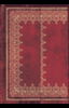
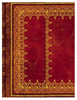
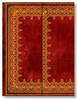
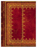
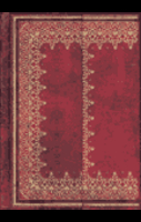
Foiled Leather Journal (Large) - Ruled

A lined journal, in an ingeniously printed faux leather cover which captures the flavour of finely wrought Renaissance-style leather bindings. It is intricately embellished with one of three designs to reproduce the delicate gold tooling which was brought to Europe via the flourishing trade routes with the east.Closes with a fold-over cover flap. Smythe sewn with 144 pages, plus memento pouch and ribbon page marker. 18x23cm
RIP - This product is no longer available on our network. It was last seen on 25.09.2019

This page now acts as a permanent archive for this product. Add more information using the comments box below to ensure it can still be found by future generations.

Use our search facility to see if it is available from an alternative contributor.
  • External links may include paid for promotion
  • Availability: Out Of Stock
  • Supplier: Stanfords
  • SKU: 9781551562841
Availability: In Stock
£16.99

Product Description

A lined journal, in an ingeniously printed faux leather cover which captures the flavour of finely wrought Renaissance-style leather bindings. It is intricately embellished with one of three designs to reproduce the delicate gold tooling which was brought to Europe via the flourishing trade routes with the east. Closes with a fold-over cover flap. Smythe sewn with 144 pages, plus memento pouch & ribbon page marker. 18x 23cm

Reviews/Comments

Add New

Price History

Vouchers

No voucher codes found.
Do you know a voucher code for this product or supplier? Add it to Insights for others to use.

Facebook

Jargon Buster

Leather - Durable and flexible made from the tanning of an animals raw hide
Gold - A precious highly conductive metal
ribbon - A thin band of material usually cloth, plastic or metal used primarily for tying and binding.
Leather - Made from animal hides, is a flexible and durable material
Large - something that takes up more space than normal.
Gold - A colour, a type of rich metal. Chemical symbol AU.
Flavour - The taste of a food product.
Faux - Something that is not genuine and imitation on what is real. Something that is subtle yet comes across in an effective way. Something that shows that it is better that others via presenting something new. A bohemian kwirky slogan referring to eccentricity. A large animal with four legs that tends to be ridden. Relating to temperature control. A large motor vehicle regularly used on farms. Something that tends to be able to walk through usually accompanied by a gate A purchasers guarantee
Embellished - When an item becomes more appealing de to its decorative features, for example sequins on a top.

Supplier Information

Stanfords
Stanfords was established in 1853 and opened their iconic Covent Garden flagship store in 1901. They have become the top retailer of maps, travel books and accessories in the UK and arguably offer the largest selection of maps and travel books worldwide. Famous names such as Captain Robert Falcon Scott, Ranulph Fiennes and Michael Palin have purchased from Stanfords. They now have a shop in Bristol and both stores together with other venues operate a calendar of events including talks, book signings and exhibitions. As a specialist map retailer, the map selection is comprehensive and includes road maps, street maps and walking maps from worldwide destinations, as well as a selection of world atlases and wall maps. Books include travel guides and travel literature. Stanfords also stock globes, from miniatures made of blue marble to magnificent floor-standing globes. The website features a selection of interesting articles on travel topics.
Page Updated: 2023-11-12 20:15:36

Community Generated Product Tags

Oh No! The productWIKI community hasn't generated any tags for this product yet!
Menu