
 United Kingdom
 France
 Germany
 Netherlands
 Sweden
 USA
USA
 Italy
Italy
 Spain
Spain
More From Contributor


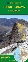
Fogo - Brava
Fogo and Brava in the Cape Verde archipelago on a detailed, GPS compatible, contoured map at 1:50, 000 from AB Kartenverlag highlighting over 50 hiking routes, with a street plan of central São Filipe.The map has contours at 100m intervals, spot heights and elevation colouring enhanced by relief shading to present the topography. Roads and tracks are clearly marked, as well as places of interest and various local facilities, including medical centres.Also highlighted on the map are over 50 selected walks, all graded according to the degree of difficulty, the type of terrain, ascent/descent and the average hiking time. Each walk is also annotated to show if the route is suitable for a mountain bike.The map is GPS compatible and has latitude and longitude grid at 1` intervals. Map
legend and all text include English.On the reverse of the map beautiful colour photos show some of the views along the routes. Also included are insets with a street plan of central São Filipe annotated with places of interest and facilities, plus a map of Fogo showing the extent of lava flows from various eruptions between 1724 and 1995.
legend and all text include English.On the reverse of the map beautiful colour photos show some of the views along the routes. Also included are insets with a street plan of central São Filipe annotated with places of interest and facilities, plus a map of Fogo showing the extent of lava flows from various eruptions between 1724 and 1995.

Product Description
Reviews/Comments
Add New
Vouchers
No voucher codes found.
Do you know a voucher code for this product or supplier? Add it to Insights for others to use.
Do you know a voucher code for this product or supplier? Add it to Insights for others to use.
 Denmark