More From Contributor
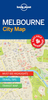
£6.99
Melbourne in the Smart Guide series from Insight is a streamlined version of travel information, in a concise format arranged in three sections
- Areas, A-Z & Atlas. Areas & districts in & around town are described before the guide moves on to an A-Z detailing of attractions & services, from accommodation to transportation via history & nightlife. The guide has some language tips, a climate chart & an overview of top attractions shown on its fly-leaf. A selective, indexed mini Atlas of a few maps at the back of each guide helps place sites & attractions for the tourist & each guide is illustrated with colour photographs throughout.
...
Archived Product
£9.99
Melbourne’s central districts on an indexed street plan from ITMB with tram routes shown with line numbers & stops, highlighting for important buildings & selected hotels, plus diagrams of the commuter rail & tram networks, etc. The plan is very clearly laid out, prominently showing main traffic arteries, the lines of the Yarra Trams network including the route of the City Circle Free Tram around the CBD district, & the stations of the Connex Melbourne commuter railways. Important buildings are named & the plan also highlights locations of selected hotels, shopping centres, cultural institutions, consulates, etc. Also provided are diagrams of the tram & the commuter rail networks, plus a small road map showing the city with its outer suburbs. ...
Archived Product
£4.99
Durable & waterproof, with a handy slipcase & an easy-fold format, Lonely Planet Melbourne City Map is your conveniently-sized passport to traveling with ease. Get more from your map & your trip with images & information about top city attractions, transport maps, itinerary suggestions, extensive street & site index, & practical travel tips & directory. With this easy-to-use, full colour navigation tool in your rear pocket, you can truly get to the heart of Melbourne. Covers City Centre, Docklands, Southbank, Williamstown, South Melbourne, Port Melbourne, Albert Park, South Yarra, Prahran, Windsor, East Melbourne, Richmond, Fitzroy, Collingwood, Carlton, North Melbourne, St Kilda. ...
Archived Product
£6.99
Melbourne in the Luxe guides series, which are slim & small enough to fit easily in a pocket or handbag. Information is distilled from elite suggestions by city residents, specially selected for their style, knowledge & expertise. Luxe guides aim at the upper end of the market & subjectively edit to choose the very best recommendations for shopping, restaurants, leisure options & nightlife. Half day shopping & activity itineraries are suggested for you to mix & match your visit to suit your timetable. When folded close the cardboard guide slots into its own protective plastic frame. Vanity Fair magazine calls them “delightful, de-lovely, & deluxe”, & that’s just what they are. ...
Archived Product
£14.99
Melbourne is a right bobby dazzler, but unlike her flashier sister Sydney, she ain`t one to show off her goodies
- most of her
...
Archived Product
£2.99
Melbourne Pop-Out Map from Compass Maps in a series designed to provide two street plans, the city centre plus a wider area around it, in a handy format to fit neatly all but the smallest pockets, with, as appropriate, transport network diagrams, additional useful maps, etc. Each title ...
Archived Product
£8.99
Melbourne in the Step by Step series by Insight Guides focuses on providing tailor made walks & tours around the city. The guide features fourteen route recommendations that link up better known sights & take you off of the more beaten track; they are written by local experts who have personally selected places to eat & drink en-route & who offer insider tips on culture, shopping & nightlife. The guide has an array of colour photographs which help bring to life the background & descriptive information provided for destinations & attractions. An overview chapter opens the guide & reviews geography, customs & culture, history, food & drink, shopping, culture & entertainment. Next feature the selected itineraries for walks and/or tours, each of which have a good amount of accompanying information & come with a simple route plan. A user friendly alphabetical directory lists practical information to do with day to day basics & listings of h&-picked hotels & restaurants are provided to suit different budgets & tastes. The publisher ...
Archived Product
£10.99
The southern coastal region of Australia between Melbourne & Adelaide on a road map from Hema in their “ City to City” series linking Australia’s main centres of population; plus more detailed coverage of the Great Ocean Road & extensive additional tourist information. The main map at 1:900, 000 covers the coast between Melbourne & Adelaide, extending north to Victoria’s northern border along the Murray River. The map highlights the three main intercity connections: the princes Highway, the Western & Duke Highways, & the Calder & Strut Highways. Road network indicates freeways, sealed & unsealed roads & tracks, presenting them as appropriate with road numbers and/or names. Driving distances are marked on main & many local routes. Topography is indicated by names of hill ranges, plus graphics for swamps, dry lakes, salt flats, etc. National park & other protected areas are prominently highlighted. Symbols show campsites & caravan parks, rest areas with overnight accommodation, 24hour fuel supplies, information centres, other places of interest, etc. Latitude & longitude lines are drawn at 1º intervals. The map is accompanied by two panels showing main roads across the suburbs of Melbourne & Adelaide, plus distance tables for the three main highway connections. On the reverse the Great Ocean Road between Geelong & Victoria’s border with South Australia is presented in greater detail at 1:450, 000, with descriptions of 24 points of special interest highlighted on the map. The reverse side also carries descriptions of other places of interest in the whole region covered by the main map, a list of accredited information centres, plus a table of facilities on local national parks. To see the list of other titles in Hema’s City to City series please click on the series link. ...
Archived Product
£10.99
The south-eastern corner of Australia between Melbourne & Sydney on an indexed road map at 1:900, 000 from Hema, with enlargements showing suburban roads in these two cities, distance tables for the Hume & Princes Highways, plus on the reverse extensive tourist information including a table of facilities in the national parks. Coverage inland extends to the Lachan Valley in NSW in the north-western corner of the map & in the Sydney region

Includes::
the Great Western Highway across the Blue Mountain National Park, with Bathurst on the northern edge of the map. Road network indicates sealed or unsealed roads & 4WD tracks, with driving distances marked on main routes. The two main routes between the two cities, the Hume & the Prices Highway are highlighted, with a distance table for each placed one next to the map. Icons indicate various facilities including camping areas & caravan parks, different types of rest areas, a selection of 24hr fuel stations, visitor centres, etc. Topography is very effectively presented by relief shading plus spot heights & names of mountain ranges, etc, plus colouring indicating national or state parks & other protected areas where the map also shows numerous hiking trails. Latitude & longitude lines are drawn at 1º intervals. The map is indexed &

Includes::
two additional panels presenting in greater detail through roads across the suburbs or Melbourne & Sydney. On the reverse is a table showing what facilities can be found in over 90 national parks, contact details for Visitor Information Centres, plus extensive notes about the region’s best sights, many illustrated with colour photos. To see the list of titles in this series please click on the series link.


...
Archived Product
£6.99
Melbourne City Pocket Map from UBD Gregpry’s combining street plans of Melbourne’s CDB districts, indexed for streets & selected buildings/institutions, with on the reverse a road map of the city with its outer suburbs. On one side is a very detailed street plan of the city’s Central Business District, extending south to the Government House. The plan highlights main traffic arteries & shows one way streets. Numerous individual buildings are named & streets are annotated with selected house numbers for easier identification of addresses. Symbols highlight various facilities & places of interest. The plan has both a street index & a separate extensive “ Building Index” listing hotels/motels, major banks, car parks, shopping complexes/markets, theatres/cinemas & tourist information offices. On the reverse is a road map of the city & its suburbs at 1:120, 000 with an index of localities & main streets, plus of Melbourne’s suburban highlights. To see a list of other street plans & directories from UBD Gregory`s please click on the series link. ...
Archived Product

Melbourne PopOut

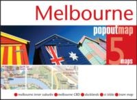
Melbourne PopOut Map: pop-up city street map of Melbourne city centre - folded pocket size travel map with transit map included Contents include maps of: * Melbourne inner suburbs * Melbourne CBD * Docklands * St Kilda * Tram map The ultimate pocket map of Melbourne! Explore Melbourne with the help of this genuinely pocket-sized, pop-up map. Small in size, yet big on detail, this compact, dependable city map will ensure you don`t miss a thing. * Includes two pop-up maps covering the inner suburbs and the CBD * Additional maps covering the docklands, St Kilda and a tram map are also included * Handy, self-folding tourist map is small enough to fit in your pocket yet offers extensive coverage of the city in an easy-to-use format * Thorough street index is also featured and
cross-referenced to the map so you can easily find your destination * Hotels, restaurants, stores and attractions are all included
RIP - This product is no longer available on our network. It was last seen on 25.09.2019

This page now acts as a permanent archive for this product. Add more information using the comments box below to ensure it can still be found by future generations.

Use our search facility to see if it is available from an alternative contributor.
  • Availability: Out Of Stock
  • Supplier: Stanfords
  • SKU: 9781845879938
Availability: In Stock
£3.99

Product Description

Melbourne Pop Out Map: pop-up city street map of Melbourne city centre
- folded pocket size travel map with transit map included Contents include maps of: * Melbourne inner suburbs * Melbourne CBD * Docklands * St Kilda * Tram map The ultimate pocket map of Melbourne! Explore Melbourne with the help of this genuinely pocket-sized, pop-up map. Small in size, yet big on detail, this compact, dependable city map will ensure you don`t miss a thing. *

Includes::
two pop-up maps covering the inner suburbs & the CBD * Additional maps covering the docklands, St Kilda & a tram map are also included * Handy, self-folding tourist map is small enough to fit in your pocket yet offers extensive coverage of the city in an easy-to-use format * Thorough street index is also featured & cross-referenced to the map so you can easily find your destination * Hotels, restaurants, stores & attractions are all included

Reviews/Comments

Add New

Intelligent Comparison

Oooops!
We couldn't find anything!
Perhaps this product's unique.... Or perhaps we are still looking for comparisons!
Click to bump this page and we'll hurry up.

Price History

Vouchers

No voucher codes found.
Do you know a voucher code for this product or supplier? Add it to Insights for others to use.

Facebook

Jargon Buster

compact - Carefuly designed to ensure an item has a minimal physical size
Size - is the measurement of how big an object is in space.
Small - something that takes up less space than normal.
Compact - something that has a lot combined within a small space.
Tram - A large vehicle common in cities for public transport, also known as a cable car.
Pocket - A bag shaped insert in clothing used to carry items

Supplier Information

Stanfords
Stanfords was established in 1853 and opened their iconic Covent Garden flagship store in 1901. They have become the top retailer of maps, travel books and accessories in the UK and arguably offer the largest selection of maps and travel books worldwide. Famous names such as Captain Robert Falcon Scott, Ranulph Fiennes and Michael Palin have purchased from Stanfords. They now have a shop in Bristol and both stores together with other venues operate a calendar of events including talks, book signings and exhibitions. As a specialist map retailer, the map selection is comprehensive and includes road maps, street maps and walking maps from worldwide destinations, as well as a selection of world atlases and wall maps. Books include travel guides and travel literature. Stanfords also stock globes, from miniatures made of blue marble to magnificent floor-standing globes. The website features a selection of interesting articles on travel topics.
Page Updated: 2023-11-12 20:15:36

Community Generated Product Tags

Oh No! The productWIKI community hasn't generated any tags for this product yet!
Menu