More From Contributor
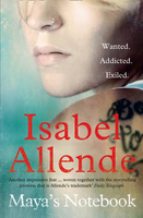
£12.95
Rewritten from cover to cover & updated to include the discoveries & new theories from the past decade & a half, this classic guide to the art of the ancient Maya is now illustrated in full colour throughout. World expert Mary Miller & her co-author Megan ONeil take the reader through the visual world of the Maya, explaining how & why they created the paintings, sculpture & monuments that intrigue & compel people the world over. With an array of new material, from recent finds including the La Corona panels, to new studies of the monuments at Palenque, Zotz & elsewhere, to the beautiful wall paintings discovered in recent years, this new edition will be essential reading for students & scholars & for travellers to the cities of this mysterious civilization. ...
Archived Product
£48.00
This volume provides a panoramic overview of Mayan civilization, interweaving essays by experts in the field with illustrations of the objects that the Mayan people left behind. The book illuminates topics including cities, architecture, script, the calendar, gods, ceramics, murals, trade, politics & the Maya today. A sophisticated artistic expression in sculpture, painting & pottery emerges, alongside: the Mayan concepts of time & space; their intriguing cosmic & cosmological theories; their mysterious religious beliefs; their complex economic, social & political organizations; & other cultural expressions such as an alphabetical system & antique codices that have survived through the ages. ...
Archived Product
£8.95
Road map highlighting the Maya ruins of southern Mexico, Guatemala, Belize, El Salvador & western Honduras, with detailed plans of the major archaeological sites. Coverage of Mexico extends westward to just beyond Villahermosa & Tuxtla Gutierrez, & in the east the map extends to San Pedro Sula in Honduras & San Miguel in El Salvador. The area ...
Archived Product
£9.95
Mayan Adventure Map from Can-Do Publishing with extensive tourist information. A guide rather than a conventional map, this title has plans of & information on Maya sites & other attractions, plus accommodation, restaurants, bars & clubs, etc. Presented in two separate, double-sided pieces, this title contains: A 61 x 92cm main sheet covering on one side the area from the Cancun to Piste & Chichen Itza, & southward along the coast to Tulum. Road network, presented in a more schematic rather than conventional format, is annotated with various facilities & places of interest, including fuel supplies, GPS waypoints for important junctions, kilometre markers, etc. Enlargements show locations of toll booths & index panels help to locate various towns & villages, plus attractions. Also provided is a plan of the Maya ruins in Tulum. On the reverse are plans of the ruins at Chichen Itza, a map of Piste, plus plans of other sites in that area, including the Balankanche cave, Yokdzonot & Ik-Kil cenotes & Yaxunah. A 61 x 43cm sheet providing on one side a plan of Valladolid & on the reverse maps of the sites at Ek Balam & Coba, plus other attractions accessible from Valladolid. Both sheets include numerous panels with information on accommodation, restaurants & bars, attractions, recreational facilities, etc. Plans of Maya ruins have details of opening times, admission fees, parking, etc. ...
Archived Product
£13.99
Mayan World Travel Atlas from ITBM combining their mapping of southern Mexico, Guatemala, Belize, Honduras & El Salvador into one A5, paperback atlas with street plans of the capitals and/or enlargements popular areas. All the maps have altitude colouring, although in different grades & in Honduras in feet while the other countries are in metres. Elevation given for spot heights is also not consistent. The maps show the road & rail networks & highlight various places of interest. All the maps have lines of latitude & longitude. Accompanying street plans cover the central parts of the city, show names of main streets & indicate locations of selected hotels & various facilities, etc. The scales are:- Mexico: Yucatan at 1:500, 000, plus the states of Tabasco & Chiapas at 1:1, 000, 000- Guatemala at 1:470, 000, with street plans of Guatemala City & Antigua, plus an enlargement of the environs of Guatemala City- Belize at 1:250, 000 with a street plan of Belize City- Honduras at 1:750, 000 with a street plan of Tegucigalpa- El Salvador at 1:250, 000 with an enlargement for the environs of San Salvador ...
Archived Product
£6.99
The war is over & Felix, Gabriel & Anya go back to the farmhouse, only the neighbours make it quite clear that they are not welcome. After a violent scene in the market square, Felix is rescued by the military & promised a new start in Australia. & so, despite the pain of leaving Gabriek behind, Felix & Anya take their chance
- maybe, just maybe, they will find safety? This powerfully moving addition to Morris Gleitzman`s bestselling series takes place in 1945, following directly on from the story told in SOON. This intensely affecting story will move readers of all ages. It will be welcomed by the many Holocaust educators who use Once, Now, Then & After to teach upper primary & lower secondary children & embraced by any reader who loves passionate, moving & brilliant stories.
...
Archived Product
£2.50
Maybole street map from Nicolson Maps; coverage

Includes::
Crosshill, Dailly, Girvan, Kirkmichael, Kirkoswald,

...
Archived Product
£5.00
Designed to be displayed near the DSC VHF this essential reference card has blank spaces where you can write your boat name, MMSI number & call sign using a permanent marker pen. The first part of the card leads the user through the DSC Alert & the second part shows the spoken Mayday procedure. Printed using light-fast ink & encapsulated with a heavy duty plastic for cockpit use & abuse. Card to be kept near radio listing procedure for Mayday call. ...
Archived Product
£20.00
Lifeboats occupy a particular place in people`s hearts as unpaid volunteers regularly take to their boats often in extremely adverse conditions to rescue others from the sea. The stories that go with lifeboats & their crews are those of courage, sacrifice, community & our coastline. No matter if one is on holiday by the coast, or living inl&, we are always aware of the work these brave crews do, & also aware of the tremendous affection the RNLI has throughout the whole of the British Isles. An island race appreciates those who risk their lives continually to help those endangered at sea. May-Day! May-Day! showcases the work, over many years, that the RNLI crews have undertaken, using the technology & training of their time to go out into dangerous waters to rescue people. It contains a great deal of useful/technical information to give the reader all the background information to the science of saving lives at sea. The RNLI is close to the hearts of the British public, who want to know more about their work today, but also historically how they have evolved. With archive material, first-person interviews of station commanders, rescuers, etc. plus scientific illustrations & maps, this book will be the first to bring together the history & technology, people & crews, triumphs & disasters of the RNLI together in one book. ...
Archived Product
£12.99
Topographic survey of France at 1:25, 000 in IGN`s excellent TOP25 / Série Bleue series. All the maps are GPS compatible, with a 1km UTM grid plus latitude & longitude lines at 5’ intervals. Contours are at 5m intervals except for mountainous areas where the maps have contours at 10m intervals, vividly enhanced by hill shading & graphics for rocky terrain. Colouring with graphics indicates different types of vegetation or land use (deciduous or coniferous forests, moors, orchards, vineyards, etc). PLEASE NOTE: coverage of France at this scale is currently being revised – the format & the presentation of each title are indicated by the letters at the end of its Sheet Reference number (e.g. 0416ET, 3531ETR, 1923SB, etc.)MAPS WITH FULL TOURIST OVERPRINT & AN ENGLISH MAP LEGEND: all TOP25 maps & the SB editions of Série Bleue have an overprint highlighting waymarked walking trails including long-distance GR routes &, where appropriate, ski routes. Symbols indicate campsites, gîtes d’etape, refuges, equestrian centres & other recreational facilities or sites, tourist information centres, cultural heritage, etc. Towns & locations of particular interest are highlighted.- ET or OT = single-sided TOP25 map covering approx. 29x 21 km / 18x 13 miles.- ETR or OTR = waterproof & tear resistant TOP25 map covering the same area as the corresponding ET or OT number, but double-sided, printed on a smaller size sheet with a good overlap between the sides.- SB = Série Bleue map with full tourist overprint; these maps, first introduced in summer 2014, each cover approx. 29x 24km / 18x 15 miles.SÉRIE BLEUE maps with numbers ending in E (Est) or O (Ouest): most editions now indicate the GR routes, but do not show any other tourist information. Map legend is in French only. Each map covers approx. 14x 20km / 9x 12 miles. ...
Archived Product

Maya`s Notebook

The author of `The House of the Spirits` returns with a gritty yet transcendent tale of teenage addiction. Abandoned by her parents as a baby, Maya has been brought up by her tough grandmother Nini and her gentle grandfather Popo. But at school, the teenage Maya finds herself drawn towards the wrong crowd. Before she knows what`s happened, Maya`s life has turned into one of drug addiction and crime. Things go from bad to worse as Maya disappears into the criminal underworld. To save her from her old associates, Nini sends Maya to a remote island off the coast of Chile. Safe amongst her new neighbours, Maya feels compelled to write her story and slowly she begins to heal. But can she learn to live with her scars, and will her past ever catch up with her?
RIP - This product is no longer available on our network. It was last seen on 25.09.2019

This page now acts as a permanent archive for this product. Add more information using the comments box below to ensure it can still be found by future generations.

Use our search facility to see if it is available from an alternative contributor.
  • Availability: Out Of Stock
  • Supplier: Stanfords
  • SKU: 9780007482856
Availability: In Stock
£8.99

Product Description

The author of ` The House of the Spirits` returns with a gritty yet transcendent tale of teenage addiction. Abandoned by her parents as a baby, Maya has been brought up by her tough grandmother Nini & her gentle grandfather Popo. But at school, the teenage Maya finds herself drawn towards the wrong crowd. Before she knows what`s happened, Maya`s life has turned into one of drug addiction & crime. Things go from bad to worse as Maya disappears into the criminal underworld. To save her from her old associates, Nini sends Maya to a remote island off the coast of Chile. Safe amongst her new neighbours, Maya feels compelled to write her story & slowly she begins to heal. But can she learn to live with her scars, & will her past ever catch up with her?

Reviews/Comments

Add New

Intelligent Comparison

Oooops!
We couldn't find anything!
Perhaps this product's unique.... Or perhaps we are still looking for comparisons!
Click to bump this page and we'll hurry up.

Price History

Vouchers

No voucher codes found.
Do you know a voucher code for this product or supplier? Add it to Insights for others to use.

Facebook

Jargon Buster

Addiction - The description given when someone cannot live without something.

Supplier Information

Stanfords
Stanfords was established in 1853 and opened their iconic Covent Garden flagship store in 1901. They have become the top retailer of maps, travel books and accessories in the UK and arguably offer the largest selection of maps and travel books worldwide. Famous names such as Captain Robert Falcon Scott, Ranulph Fiennes and Michael Palin have purchased from Stanfords. They now have a shop in Bristol and both stores together with other venues operate a calendar of events including talks, book signings and exhibitions. As a specialist map retailer, the map selection is comprehensive and includes road maps, street maps and walking maps from worldwide destinations, as well as a selection of world atlases and wall maps. Books include travel guides and travel literature. Stanfords also stock globes, from miniatures made of blue marble to magnificent floor-standing globes. The website features a selection of interesting articles on travel topics.
Page Updated: 2023-11-12 20:15:36

Community Generated Product Tags

Oh No! The productWIKI community hasn't generated any tags for this product yet!
Menu