
 United Kingdom
 France
 Germany
 Netherlands
 Sweden
 USA
USA
 Italy
Italy
 Spain
Spain
More From Contributor


Sweden Southern
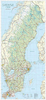
Southern Sweden on a road map at 1:650, 000 from the country’s leading map publishers Norstedts, providing coverage extending north well beyond Stockholm and Gävle to Sundsvall. Road network, from motorways to privately maintained local roads, is clearly presented on a base which shows the landscape by light colouring for altitude and woodlands, plus spot heights and names of main topographic features. Driving distances are marked on main routes. One quibble – motorway junction numbers (shown on the publishers’ road map of the whole country) are not included.Coverage of the adjoining parts of Norway includes Oslo and in Demark a part of Zealand with, of course, ’that bridge’; only main road are shown. The map has no geographical coordinates and is not indexed. Map legend
includes English.
includes English.

Product Description
Reviews/Comments
Add New
Vouchers
No voucher codes found.
Do you know a voucher code for this product or supplier? Add it to Insights for others to use.
Do you know a voucher code for this product or supplier? Add it to Insights for others to use.
 Denmark