More From Contributor
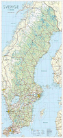
£11.50
Southern Sweden at 1:500, 000 on an indexed, waterproof & tear-resistant road map with topographic & tourist information, published by Reise Know-How as part of their highly acclaimed World Mapping Project. The map is double-sided to provide the best balance between a good scale & a convenient size sheet. Coverage extends north beyond Stockholm & Uppsala to include the Färnebofjärdens National Park, with Gothenburg conveniently shown on both sides of the map. Gotland is shown as an inset. Road & rail networks are easy to see on a clear base. Road network

Includes::
motorway, main & secondary roads as well as many selected local roads. Road numbers & distance markers in kilometres are given for main inert-city & cross-country routes. Railway lines & ferry routes are shown as are international & domestic airports. The map also shows internal administrative boundaries with names of the provinces. The map indicates various places of interest, including campsites, national parks, archaeological remains, UNESCO world heritage sites, notable viewpoints, etc. Latitude & longitude lines are drawn at 30’ intervals & the map is indexed. Map legend

Includes::
English.


...
Archived Product
£10.99
Sweden South-West: Gothenburg
- Vänersee
- Karlstad area in a series of detailed, indexed touring maps from Freytag & Berndt

...
Archived Product
£10.99
Sweden South-East: Stockholm
- Uppsala
- Norrköping area in a series of detailed, indexed touring maps from Freytag & Berndt

...
Archived Product
£10.99
Southern Sweden on a road map at 1:650, 000 from the country’s leading map publishers Norstedts, providing coverage extending north well beyond Stockholm & Gävle to Sundsvall. Road network, from motorways to privately maintained local roads, is clearly presented on a base which shows the landscape by light colouring for altitude & woodlands, plus spot heights & names of main topographic features. Driving distances are marked on main routes. One quibble – motorway junction numbers (shown on the publishers’ road map of the whole country) are not included. Coverage of the adjoining parts of Norway

Includes::
Oslo & in Demark a part of Zealand with, of course, ’that bridge’; only main road are shown. The map has no geographical coordinates & is not indexed. Map legend

Includes::
English.


...
Archived Product
£14.99
Explore Sweden with Lonely Planet. With our 4th edition you'll discover the many sides to this diverse country
- camp out by the
...
Archived Product
£20.00
Cloth-backed reproduction of a map published by James Wyld in 1828 covering not just Sweden & Norway but also the rest of the Baltic Sea basin – using present day boundaries: all of Finland & the Gulf of Finland including St Petersburg, Estonia, Latvia, most of Lithuania, northern Pol&, both the Baltic & the North Sea coast of Germany, & Denmark. Within Norway & Sweden boundaries of the administrative units are marked. Topography is shown by hachures. The scale is shown in English statute miles, plus also in the Swedish, Danish, German & Russian equivalents. This reproduction was taken from what used to be called a “cloth-dissected” map, made when the map itself was cut into sections & each section then individually pasted onto an overall cloth backing for the whole map. In this version the whole map is backed onto cloth in one piece but the gaps between the sections have been reproduced in the printing to preserve the style & the feeling of the original. Each individual cloth-backed map is sold folded in a colourful case covered with a unique design marbled paper – no two cases are identical.PLEASE NOTE: to see the list of all the titles in this series from the Old Folding Maps please click on the series link. ...
Archived Product
£10.99
Sweden on detailed, indexed touring maps from Freytag & Berndt with the southern & central part of the country at 1:250, 000 & the north at 1:400, 000. Relief shading & spot heights show the topography. Road network

Includes::
what is confusingly described in the map legend as “private” roads, unsurfaced roads open to the general public but simply privately maintained, & indicates toll routes, restrictions & winter closures, steep gradients, motorway services, etc. Scenic roads & special tourist routes are highlighted. Railways with stations, ferry services, & local administrative boundaries are marked. National parks & prohibited areas are highlighted & symbols show places of interest, campsites, mountain shelters, youth hostels, etc. The maps of southern & central Sweden have latitude & longitude lines drawn at 10` intervals, with 30` on the two northern sheets. Multilingual map legend

Includes::
English. A place name index, with post codes, is provided in a booklet attached to the map cover.


...
Archived Product
£16.99
Topographic survey of Sweden at 1:100, 000, the Vägkartan, from the Lantmäteriet, covering most of the country in 79 double-sided maps. Please note: the mountainous regions of central & northern Sweden are not covered by this series but presented in a separate “ Fjällkartan
- Mountain Map” series also listed on our website. Each 1:100, 000 topographic survey map covers an area of 75 x 80km. The maps have contours at 10 metre intervals, plus relief shading & colouring for different types of landscape: open l&, forests, alvar, marshes, etc. Boundaries of national parks & nature reserves, areas prohibited to cross-country vehicles, & restricted entry military zones are marked. The maps indicate privately maintained local roads, cycle paths with wind shelters, footpaths, etc, & include all other information expected of topographic survey at this scale. The maps have a 2-km UTM grid, plus latitude & longitude lines 10’ intervals. Map legend

Includes::
English. For coverage of the country’s most visited hiking areas in central & northern Sweden please see Lantmäteriet’s Mountain Map series, listed separately on our website.


...
Archived Product
£16.99
Mountain areas of central & northern Sweden on waterproof & tear-resistant, GPS compatible topographic “ Fjällkartan” maps at 1:100, 000 & 1:50, 000 from Lantmäteriet
- the country’s national survey organization, with hiking & ski routes, campsites & youth hostels, etc. Relief is shown by contours at 20m intervals & enhanced by relief shading, plus colouring and/or graphics to indicate different types of vegetation or land use. An overprint shows trails for hiking & cross-country skiing, indicating waymarked or unmarked & summer or winter only routes. Also shown are mandatory & recommended trails for snowmobiles & areas prohibited for cross-country vehicles. Symbols indicate locations of campsites, youth hostels, huts & wind shelters, mountain lodges & other types of tourist accommodation, emergency telephones, etc. The maps have both a 1-km UTM grid & a latitude/longitude grid in steps of 10`. Map legend

Includes::
English. On the reverse there are descriptions of the area in Swedish only, GPS coordinates for selected locations, etc. Most sheets also include a brief note in English on public access regulations.PLEASE NOTE: for the area from map Z3 northwards this series provides the most detailed topographic coverage available
- Lantmäteriet does not cover this region at 1:50, 000.


...
Archived Product
£16.99
Topographic survey of Sweden at 1:250, 000, the -versiktkartan, from the Lantmäteriet on 21 double-sided maps each covering an area of 187.5 x 100km. Contour interval is 25m below 600 metres & 50m above 600m. Colouring and/or graphics indicate built up areas with under or over 200 inhabitants, forests, open l&, alvar & marshes. Boundaries of national parks or nature reserves & restricted military zones are marked. The maps indicate privately maintained local roads, show railway lines with stations, etc. UTM grid is drawn a 10-km intervals, with latitude & longitude lines at 30’. Map legend

Includes::
English.PLEASE NOTE: southern & central Sweden is more conveniently covered at 1:250, 000 by regional road maps from Norstedts Kartförlaget with similar cartography (no contours or UTM grid) & tourist information.

...
Archived Product

Sweden Wall Map

Sweden on a wall map at 1:1, 000, 000 from Norstedts, size 74x160cm (29”x63” approx), showing the country’s road and rail networks on a base with very effective presentation of the landscape by satellite-based relief shading and colouring for woodlands, marshes, etc, plus plenty of spot heights, names of various topographic features and boundaries of national parks. Also marked are the boundaries of Sweden’s administrative provinces. Communications network extends to the adjoining areas of Denmark, Norway and Finland, but not the topographic information. Map legend is in Swedish only.
RIP - This product is no longer available on our network. It was last seen on 25.09.2019

This page now acts as a permanent archive for this product. Add more information using the comments box below to ensure it can still be found by future generations.

Use our search facility to see if it is available from an alternative contributor.
  • External links may include paid for promotion
  • Availability: Out Of Stock
  • Supplier: Stanfords
  • SKU: 9789158891357
Availability: In Stock
£24.95

Product Description

Sweden on a wall map at 1:1, 000, 000 from Norstedts, size 74x 160cm (29”x 63” approx), showing the country’s road & rail networks on a base with very effective presentation of the landscape by satellite-based relief shading & colouring for woodlands, marshes, etc, plus plenty of spot heights, names of various topographic features & boundaries of national parks. Also marked are the boundaries of Sweden’s administrative provinces. Communications network extends to the adjoining areas of Denmark, Norway & Finl&, but not the topographic information. Map legend is in Swedish only.

Reviews/Comments

Add New

Intelligent Comparison

Oooops!
We couldn't find anything!
Perhaps this product's unique.... Or perhaps we are still looking for comparisons!
Click to bump this page and we'll hurry up.

Price History

Vouchers

No voucher codes found.
Do you know a voucher code for this product or supplier? Add it to Insights for others to use.

Facebook

Jargon Buster

Denmark - A country in Scandinavia, Northern Europe.
Wall - A physical barrier between two areas
Size - is the measurement of how big an object is in space.
Network - A link and communication between things. Often computers or people.
Road - a manmade lane or a path that is used to speed up travel.

Supplier Information

Stanfords
Stanfords was established in 1853 and opened their iconic Covent Garden flagship store in 1901. They have become the top retailer of maps, travel books and accessories in the UK and arguably offer the largest selection of maps and travel books worldwide. Famous names such as Captain Robert Falcon Scott, Ranulph Fiennes and Michael Palin have purchased from Stanfords. They now have a shop in Bristol and both stores together with other venues operate a calendar of events including talks, book signings and exhibitions. As a specialist map retailer, the map selection is comprehensive and includes road maps, street maps and walking maps from worldwide destinations, as well as a selection of world atlases and wall maps. Books include travel guides and travel literature. Stanfords also stock globes, from miniatures made of blue marble to magnificent floor-standing globes. The website features a selection of interesting articles on travel topics.
Page Updated: 2023-11-12 20:15:36

Community Generated Product Tags

Oh No! The productWIKI community hasn't generated any tags for this product yet!
Menu