
 United Kingdom
 France
 Germany
 Netherlands
 Sweden
 USA
USA
 Italy
Italy
 Spain
Spain
More From Contributor


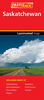

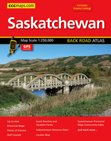
Saskatchewan Back Road Atlas
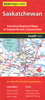
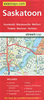
Saskatchewan road atlas presenting the province on detailed, GPS-compatible mapping at 1:250, 000, plus a table of facilities in the national and provincial parks, an extensive list of local events, an index of points of interest, etc. Mapping at 1:250, 000 covers most of the province, but without some parts of its northernmost regions, as indicated in our coverage image. Road network is presented on a base with unobtrusive relief shading; numerous small rivers and lakes are named and national or provincial parks and other protected areas are prominently highlighted. Road classification indicates unpaved or unimproved and seasonal routes; driving distances are not marked. Railway lines are included and local airports and seaplane bases are marked. Symbols indicate various facilities
and places of interest, including campgrounds, recreational areas, tourist information centres, etc. The maps have a 10km UTM grid. The index lists communities and road names.Additional features include a 9-page listing of local events, a table of facilities in the national and provincial parks, a distane table. etc.To see the list of the currently available provincial or regional road atlases from the MapArt / Canadian Cartographics Corporation / JDM Géo publishing group, please click on the series link.
and places of interest, including campgrounds, recreational areas, tourist information centres, etc. The maps have a 10km UTM grid. The index lists communities and road names.Additional features include a 9-page listing of local events, a table of facilities in the national and provincial parks, a distane table. etc.To see the list of the currently available provincial or regional road atlases from the MapArt / Canadian Cartographics Corporation / JDM Géo publishing group, please click on the series link.

Product Description
Reviews/Comments
Add New
Vouchers
No voucher codes found.
Do you know a voucher code for this product or supplier? Add it to Insights for others to use.
Do you know a voucher code for this product or supplier? Add it to Insights for others to use.
 Denmark