
 United Kingdom
 France
 Germany
 Netherlands
 Sweden
 USA
USA
 Italy
Italy
 Spain
Spain
More From Contributor

Jerusalem
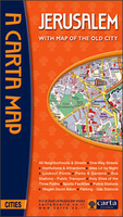
Jerusalem on a street plan from the locally based Carta, prominently highlighting historical locations and important institutions, plus separate enlargements of the central districts and of the Old Town, indexes of streets and suburbs/neighbourhoods, and lists of sights and various institutions.The main plan covers the city with its outer districts, with insets showing the settlements of Homat Shmuel (Har Homa) and East Pisgat Ze’ev. Coverage includes Mount Herzl and Yad Vashem. Main traffic arteries are highlighted, one way streets or pedestrianized areas are marked, and the plan also shows locations of petrol stations. The route of the light railway line is shown with stops. Various institutions and places of interest are highlighted and named, many shown by small drawings.
Next to the main plan is an enlargement showing in greater detail Jerusalem’s central districts between the Old City and the institutions around the Knesset, Israel Museum and the Hebrew University. On the reverse is large, very clear plan of the Old City, a street index, plus a list of various sites and institutions including suburbs and neighbourhoods, synagogues and other places of worship, museums and cultural centres, cemeteries, etc. Also provided is a small map showing the Jerusalem municipal area.All place names are in the Latin alphabet only.
Next to the main plan is an enlargement showing in greater detail Jerusalem’s central districts between the Old City and the institutions around the Knesset, Israel Museum and the Hebrew University. On the reverse is large, very clear plan of the Old City, a street index, plus a list of various sites and institutions including suburbs and neighbourhoods, synagogues and other places of worship, museums and cultural centres, cemeteries, etc. Also provided is a small map showing the Jerusalem municipal area.All place names are in the Latin alphabet only.

Product Description
Reviews/Comments
Add New
Vouchers
No voucher codes found.
Do you know a voucher code for this product or supplier? Add it to Insights for others to use.
Do you know a voucher code for this product or supplier? Add it to Insights for others to use.
 Denmark