More From Contributor

£12.99
Monocle reports from around the globe in print, on radio, & online. As its editors & correspondents dart from city to city, they get to know the best places to rest their heads, stretch their limbs, & kick back with a contact in a hard-to-find cocktail bar. That information is now available in The Monocle Travel Guide Series: a line-up of titles that speaks to you in an informed but informal way about everything from architecture to art, late-night bars to early-morning markets. Expect a mix of experiences dotted with some quirky surprises. These are books where grand hotels appear alongside family-owned bistros & internationally renowned galleries sit next to unassuming indie clubs that play host to top music talent. The Monocle Travel Guides mix the classic with the contemporary, go beyond the conventional, & reveal all the hidden spots that cities have to offer. ...
Archived Product
£9.95
Istria at 1:75, 000 on a double-sided, detailed contoured map from Kompass, with hiking & cycling routes, street plans of 10 main towns, plus tourist information. Coverage extends north beyond the border to include Trieste. Contours at 50m intervals & spot heights present the terrain. An overprint highlights hiking trails, including the E6 trans-European long-distance route, indicating steep, partially waymarked sections. Cycle & mountain bike routes are also marked. Road network

Includes::
farm roads & forest tracks. Railways are shown with stations & ferry routes are marked. Symbols indicate various tourist facilities & places of interest, including campsites & youth hostels, nudist beaches, diving & surfing sites, sport & recreational facilities, cultural monuments, etc. The map has no geographical coordinates. Map legend

Includes::
English. The map also provides street plan of central areas of Pula, Rovinj, Opatija, Vrsar, Umag, Novigrad, Porec, Piran & Portoro


...
Archived Product
£10.95
Istria at 1:75, 000 on a double-sided, waterproof & tear-resistant, detailed contoured map from Kompass, with hiking & cycling routes, street plans of 10 main towns, plus tourist information. Coverage extends north beyond the border to include Trieste. Contours at 50m intervals & spot heights present the terrain. An overprint highlights hiking trails, including the E6 trans-European long-distance route, indicating steep, partially waymarked sections. Cycle & mountain bike routes are also marked. Road network

Includes::
farm roads & forest tracks. Railways are shown with stations & ferry routes are marked. Symbols indicate various tourist facilities & places of interest, including campsites & youth hostels, nudist beaches, diving & surfing sites, sport & recreational facilities, cultural monuments, etc. The map has no geographical coordinates. Map legend

Includes::
English. The map also provides street plan of central areas of Pula, Rovinj, Opatija, Vrsar, Umag, Novigrad, Porec, Piran & Portoro


...
Archived Product
£11.99
Istria & Kvarner, the northern part of Croatia’s Adriatic coast, at 1:100, 000 on a detailed, GPS compatible double-sided road map from Kartografija in Ljubljana highlighting picturesque locations. On one side is Istria with coverage extending north to Trieste
- on the reverse the map shows the northern part of the Adriatic coast & its islands, extending south to cover all but the southernmost tip of Lošinj & Approx. half of Pag. Topography is shown by relief shading with contours at 40m intervals. Road network

Includes::
small local roads & selected cart tracks. Driving distances are shown on main & most secondary routes, & locations of border crossings & petrol stations are also marked. Railway lines are included & ferry routes are marked. An overprint highlights numerous recommended cycling routes. Pictureque locations are prominently highlighted & symbols indicate various places of interest including ordinary or nudist campsites, beaches, viewpoints, historical sites, etc. Along the coast symbols indicate marinas, harbours, anchor facilities for large craft, etc. The map also gives some bathymetric information but is not intended to be used as a sailing chart. Latitude & longitude lines are drawn at 5’ intervals. The map has no index. Map legend

Includes::
English.


...
Archived Product
£8.95
Istria
- Pula Top 10 Tips Map at 1:100, 000 from Freytag & Berndt with street plans of central Opatija, Porec, Pula, Rovinj
...
Archived Product
£18.95
Istria
- Where Croatia meets Italy is a celebration of the region's best food & travel experiences. Exploring every area of Istria,
...
Archived Product
£13.99
Istria in the Travel Guide series from Bradt; encompassing a comprehensive range of titles to destinations worldwide, with a particular focus on Africa, Central & South America. Bradt are one of the country’s leading independent publishers & have an ethos that focuses on responsible travel, in alliance with a philosophy of sustainability; both in the destinations the guides cover but also in encouraging tourists to limit the impact they have on the local environment. Bradt guides have a reputation for appealing to more independent travelers & often cover destinations that are not available from other publishers. Each guide opens with two comprehensive chapters on Background & Practical Information, covering details of the country’s geography, culture, natural history, government & politics, economy, people, language, religion, education & culture. Important practical advice

Includes::
when to visit, highlights, suggested itineraries, tour operators, red tape, embassies & consulates, getting there & away, health, safety, what to take, money, budgeting, getting around, accommodation, eating & drinking, public holidays, shopping, arts & entertainment, media & communications, business, travel culture & cultural etiquette. Individual sections are organized geographically by region & typically open with information on practicalities & orientation, before focusing on what to see & where to go. Information on what to see, where to stay, where to eat & how to find your way around is provided, with a range of budgets catered for. Simple black & white maps locate key visitor sites & places of accommodation. Bradt Travel Guides include appendices that provide an in-depth introduction to the language of each country, a glossary of terms & a listing of books & internet resources providing further information on the destination.

...
Archived Product
£14.95
Ten cycle tours throughout Istria, with detailed mapping showing the route & its variants & extensive information conveyed by symbols, indicating road surface, campsites & other accommodation, repair workshops, recreational facilities, places of interest, etc. A list of various types of accommodation facilities is included.IMPORTANT
- PLEASE NOTE: ALL THE TEXT IN THIS TITLE IS GERMAN ONLY. MAP LEGEND

Includes::
ENGLISH, please see our sample image, & the information provided on the maps is sufficient to use this title without any knowledge of German, particularly in the absence of a similar product in English from other publishers. There is currently no English edition this title available in this series. About the series: All the titles have been meticulously researched & are highly regarded in their native Germany. Most titles, as indicated in their individual descriptions, also include a separate section listing selected accommodation, from hotels to campsites, youth hostels & rooms in private houses, all with addresses, telephone numbers & price range. Information on towns along each route

Includes::
a list of places of interest, with opening hours, etc. Several of the guides also have street plans.


...
Archived Product
£4.99
Istria in a series of handy holiday pocket maps from Freytag & Berndt covering popular islands & other seaside destinations in Europe. Each map is laminated, so waterproof & tear-resistant, & highlights the publishers’ recommendations of five best choices in five categories: adventure, culture, food, nature & sights. On one side is a road map with icons highlighting numerous places of interest, including campsites & youth hostels, sport & recreational facilities, marinas & beaches, architectural & historical sites, etc. The maps have no geographical coordinates. Most titles also include a small street plan of the central area in the main town. The map &, if appropriate, the street plan are annotated with colour-coded markers highlighting the publishers’ recommendations of five best choices in five categories: adventure, culture, food, nature & sights, all listed on the reverse of the map with brief notes in several languages. Also provided is a Fact Box with phone numbers for tourist offices, car hire & emergency services. Map legend & notes on the recommendations include English.IN THIS TITLE: the map is indexed &

Includes::
a small plan of central Pula. Coverage extends to Trieste.

...
Archived Product
£5.99
With Roman ruins, Byzantine churches & Venetian town houses, this area of Croatia is stunning whatever your taste. From the ...
Archived Product

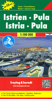
Istria - Pula F&B Top 10 Tips

Istria ”Top 10 Tips” double-sided map at 1:100, 000 from Freytag & Berndt highlighting recommended cycling trails and picturesque locations, with plans of central Pula, Rovinj, Opatija, Umag and Porec, plus descriptions of the region’s top 10 sights. Coverage extends north to include Trieste and the south-western corner of Slovenia, plus most of the nearby island of Cres.The map is double-sided with a good overlap between the sides. Topography is shown by relief shading with spot heights, with colouring for woodlands. Driving distances are marked on main and selected secondary roads. Scenic roads as well as recommended cycling routes and mountain bike trails are highlighted. Railways lines and ferry connections to the islands are marked. The map also highlights picturesque
locations, with the region’s top 10 sights prominently marked and cross-referenced to descriptions in the accompanying booklet. Symbols indicate other places of interest and facilities, including campsites and youth hostels, marinas, etc. Latitude and longitude lines are drawn at intervals of 5’. The index, listing locations with their postcodes, is in the accompanying bookletSurrounding the map are street plans of central Pula, Rovinj, Opatija, Umag and Porec, and the booklet also includes brief descriptions of several recommended cycling routes. Map legend, conveniently shown on both sides of the map, and the descriptions include English.
RIP - This product is no longer available on our network. It was last seen on 25.09.2019

This page now acts as a permanent archive for this product. Add more information using the comments box below to ensure it can still be found by future generations.

Use our search facility to see if it is available from an alternative contributor.
  • External links may include paid for promotion
  • Availability: Out Of Stock
  • Supplier: Stanfords
  • SKU: 9783707916577
Availability: In Stock
£10.99

Product Description

Istria ” Top 10 Tips” double-sided map at 1:100, 000 from Freytag & Berndt highlighting recommended cycling trails & picturesque locations, with plans of central Pula, Rovinj, Opatija, Umag & Porec, plus descriptions of the region’s top 10 sights. Coverage extends north to include Trieste & the south-western corner of Slovenia, plus most of the nearby island of Cres. The map is double-sided with a good overlap between the sides. Topography is shown by relief shading with spot heights, with colouring for woodlands. Driving distances are marked on main & selected secondary roads. Scenic roads as well as recommended cycling routes & mountain bike trails are highlighted. Railways lines & ferry connections to the islands are marked. The map also highlights picturesque locations, with the region’s top 10 sights prominently marked & cross-referenced to descriptions in the accompanying booklet. Symbols indicate other places of interest & facilities, including campsites & youth hostels, marinas, etc. Latitude & longitude lines are drawn at intervals of 5’. The index, listing locations with their postcodes, is in the accompanying booklet Surrounding the map are street plans of central Pula, Rovinj, Opatija, Umag & Porec, & the booklet also

Includes::
brief descriptions of several recommended cycling routes. Map legend, conveniently shown on both sides of the map, & the descriptions include English.

Reviews/Comments

Add New

Intelligent Comparison

Oooops!
We couldn't find anything!
Perhaps this product's unique.... Or perhaps we are still looking for comparisons!
Click to bump this page and we'll hurry up.

Price History

Vouchers

No voucher codes found.
Do you know a voucher code for this product or supplier? Add it to Insights for others to use.

Facebook

Jargon Buster

Railways - A set of tracks that have been laid for the purpose of trains to travel up and down them

Supplier Information

Stanfords
Stanfords was established in 1853 and opened their iconic Covent Garden flagship store in 1901. They have become the top retailer of maps, travel books and accessories in the UK and arguably offer the largest selection of maps and travel books worldwide. Famous names such as Captain Robert Falcon Scott, Ranulph Fiennes and Michael Palin have purchased from Stanfords. They now have a shop in Bristol and both stores together with other venues operate a calendar of events including talks, book signings and exhibitions. As a specialist map retailer, the map selection is comprehensive and includes road maps, street maps and walking maps from worldwide destinations, as well as a selection of world atlases and wall maps. Books include travel guides and travel literature. Stanfords also stock globes, from miniatures made of blue marble to magnificent floor-standing globes. The website features a selection of interesting articles on travel topics.
Page Updated: 2023-11-12 20:15:36

Community Generated Product Tags

Oh No! The productWIKI community hasn't generated any tags for this product yet!
Menu