
 United Kingdom
 France
 Germany
 Netherlands
 Sweden
 USA
USA
 Italy
Italy
 Spain
Spain
More From Contributor


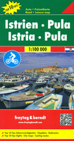
Istria - Pula 'Top 10 Tips' Map
Istria - Pula Top 10 Tips Map at 1:100, 000 from Freytag & Berndt with street plans of central Opatija, Porec, Pula, Rovinj and Umag, plus an index booklet with description of 10 top sights, all prominently highlighted on the map.Topography is shown by relief shading with spot heights, with plenty of names of mountain and hill chains, etc. National parks and other protected areas are clearly marked. Road network includes small local roads and selected cart tracks, and indicates motorway services, toll routes, tourist routes and scenic roads, etc. Railways and ferry routes to the islands are marked. Picturesque towns and villages are highlighted. The region
Product Description
Reviews/Comments
Add New
Intelligent Comparison
Archived Product
Istria - Pula F&B Top 10 Tips Stanfords
£10.99
Archived Product
Costa Del Sol 'Top 10 Tips' Map Stanfords
£9.95
Vouchers
No voucher codes found.
Do you know a voucher code for this product or supplier? Add it to Insights for others to use.
Do you know a voucher code for this product or supplier? Add it to Insights for others to use.
 Denmark