More From Contributor
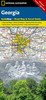
£5.99
FREE Wondercrump DOOR HANGER Inside! A brand new phizz-whizzing edition of Roald Dahl`s George`s Marvellous Medicine. George Kranky`s Grandma is a miserable grouch. George really hates that horrid old witchy woman. One Saturday morning, George is in charge of giving Grandma her medicine. So-ho! Ah-ha! Ho-hum! George knows exactly what to do. A magic medicine* it will be. One that will either cure her completely.. .or blow off the top of her head. *WARNING: Do not try to make George`s Marvellous Medicine yourselves at home. It could be dangerous. `A true genius.. . Roald Dahl is my hero`
- David Walliams
...
Archived Product
£9.99
George Kranky`s Grandma is a miserable grouch. George really hates that horrid old witchy woman. One Saturday morning, George is in charge of giving Grandma her medicine. So-ho! Ah-ha! Ho-hum! George knows exactly what to do. A magic medicine* it will be. One that will either cure her completely.. .or blow off the top of her head. *WARNING: Do not try to make George`s Marvellous Medicine yourselves at home. It could be dangerous. Read the story & listen to the phizz-whizzing audio CD! ...
Archived Product
£9.95
Georgia at 1:610, 000 an on indexed map from ITMB with a street plan of central Tbilisi & a list of architectural monuments of special interest. Bold altitude colouring shows the topography, with names of mountain ranges, peaks or spot heights, & opening times of mountain passes marked along the roads. National parks & nature reserves are highlighted. Road network

Includes::
selected country tracks, gives driving distances on main routes & locations of petrol stations. Railway lines & ferry routes along the Black Sea are included. Symbols highlight various places of interest, including religious & archaeological sites, beaches, recreational areas, etc. Place names are given in Latin alphabet. Latitude & longitude lines are drawn at 1

...
Archived Product
£9.95
Georgia at 1:500, 000 on a double-sided road map from the Tbilisi-based Geol&, showing a large number of small villages & highlighting various places of interest. Topography is shown by relief shading with spot heights, plus graphics & colouring for wetlands, salt lakes, glaciers, & different type of vegetation/land use (forests, orchards, plantations). National parks & protected areas are highlighted. Road network

Includes::
unpaved local roads, cart tracks & forestry roads. Railways are shown with stations & indicate narrow gauge lines. Local airports & Black Sea ports are marked. A range of symbols highlight various places of interest including archaeological sites, Tusheti & Svaneti towers, cave towns, beaches, etc. Also marked are oil pipelines from Azerbaijan to the Black Sea, Turkey & Armenia. The map shows internal administrative divisions into provinces, including Abkhazia & South Ossetia, & city symbols indicate their administrative status. All place names are shown in Latin alphabet only. The map has latitude & longitude lines are drawn at 15

...
Archived Product
£8.50
Georgia in a series of US state maps from the National Geographic with cartography from Mapquest, including city maps the Atlanta conurbation, downtown Atlanta, Athens, Augusta, Albany, Savannah, Brunswick/ Jekyll Isl&, Columbus & Macon, an enlargement of the Okefenokee National Wildlife Refuge, plus a scenic drive route along the coast between Jekyll Island & Savannah. Maps in the NGS State Series clearly show each state ...
Archived Product
£6.99
Georgia in a series of US state maps from the National Geographic with cartography from Mapquest, including city maps the Atlanta conurbation, downtown Atlanta, Athens, Augusta, Albany, Savannah, Brunswick/ Jekyll Isl&, Columbus & Macon, an enlargement of the Okefenokee National Wildlife Refuge, plus a scenic drive route along the coast between Jekyll Island & Savannah. The map is printed on lightweight, waterproof & tear-resistant plastic paper. Maps in the NGS State Series clearly show each state’s national parks, forests & other protected areas, with topography indicated by subtle relief shading & plenty of names of mountain ranges, valleys, deserts, etc. Indian Reservations are also marked & various places of interest are highlighted, including historical or natural sites, visitor information centres, campsites, etc. Road network indicates toll roads, rest areas & services, & shows driving distances on main routes. Scenic roads are highlighted. The maps have no geographical coordinates. The index lists both counties, shown on the maps with their administrative boundaries, & towns or cities. Each title

Includes::
several enlargements showing in greater detail local towns, national parks & other popular destination, all annotated with places of interest. Also provided are general notes about the state with descriptions of its main sights, a recommendation for a scenic drive, a table of services available in the local sites (both national parks & historical monuments), a calendar of local special events, a distance table & a climate chart.

...
Archived Product
£9.50
Georgia at 1:350, 000 on an indexed, waterproof & tear-resistant road map with topographic & tourist information, published by Reise Know-How as part of their highly acclaimed World Mapping Project. The map is double-sided, dividing the country east
- west with a good overlap between the sides. The map shows Abkhazia & South Ossetia as administrative provinces of Georgia, although their currently different status is indicated by inclusion of signs for
...
Archived Product
£17.99
This new sixth edition of Bradt`s Georgia, the only dedicated guide to the country, has been thoroughly updated throughout to include all the most recent developments, ranging from greatly expanded coverage of Batumi, Adjara & Svaneti to the addition of new maps for Tbilisi Old Town, Mestia & Telavi. Tourism is booming in Georgia: the number of guesthouses has mushroomed, Tbilisi airport has just opened a second terminal & a new terminal & rail link are under construction at Kutaisi airport. New low-cost flights are now available & visa-free travel is the norm for most. With Bradt`s Georgia discover both the old & the new. The capital, Tbilisi, has seen huge changes in the past decade with some conspicuous new projects such as the Peace Bridge, the Opera House & the Presidential Palace, as well as excellent new restaurants & bars. Much of the country can be reached in day-trips from the luxury hotels of Tbilisi & Batumi, & the remotest areas such as Svaneti & the Pankisi Valley can also now be visited. In addition, Mestia, the capital of Svaneti, now has an airport & two ski resorts. Also new for this edition is expanded information on Tusheti & the Trans Caucasian Trail, a volunteer-led project to create two long-distance hiking routes, east-west & north-south, linking the Black Sea with the Caspian, the Greater Caucasus with the Lower Caucasus & Georgia with Armenia & Azerbaijan. The Georgian wine industry is covered, with particular emphasis on natural qvevri wines, & so too are skiing, rugby, the World Heritage sites of Mtskheta & Gelati, Georgian food, fifth-century churches, cave cities, & Georgian polyphonic singing. Bradt`s unique guide to Georgia is the ideal companion for all travellers, from serious hikers to wine buffs, high-end culture lovers to backpackers of all ages. ...
Archived Product
£5.99
Georgia at 1:600, 000 on an indexed road map from the Kiev-based Kartografia, with place names shown in the Cyrillic alphabet (selected locations also in the Georgian script) & a map legend in Ukrainian. The map provides good presentation of the country’s topography through relief shading & plenty of spot heights, plus names of peaks & mountain ranges, & boundaries of national parks. Road network is graded into six types, including country tracks, shows locations of petrol stations & border crossings & gives distances on main routes. Railway lines & coastal ferry connections are included & local airports are marked. The map also indicates locations with tourist accommodation. All place names are in the Cyrillic alphabet with names of selected towns & geographic features also shown in the Georgian script. The map indicates the borders of Abkhazia & South Ossetia & within those two regions gives alternative local names for selected towns. The road network does not indicate if transit across those borders is possible. The map is indexed & has latitude & longitude lines at 1° intervals. Map legend is in Ukrainian only. Also provided is a distance table.IMPORTANT
- PLEASE NOTE BEFORE ORDERING: supplies of all titles published in the Ukraine are irregular & we cannot guarantee a firm delivery time. When a title is out of stock, it may be advisable to choose an alternative publication.
...
Archived Product
£9.99
Armenia & Georgia at 1:430, 000 on an indexed map from ITMB. Each side of the map covers the whole of one of these two countries, presented with a street plan of its capital. Diverse ethnography of the region is indicated on an inset. Topography is shown by altitude colouring in feet, with heights of peaks given in metres (and not in feet as indicated in the map legend). Mountain passes are annotated with months when passable. Swamp areas are marked & national parks or protected areas highlighted. The map shows the region’s road & rail networks, including selected seasonal tracks, & indicates local airports. Symbols highlight various places of interest: historical sites, beaches, winter sport areas, etc. All place names are in the Latin alphabet only. Latitude & longitude lines are drawn at 1° intervals. Each country has a separate index. Street plans of central Yerevan & Tbilisi name main streets & highlight various places of interest including selected foreign embassies. Also provided is an inset showing the distribution of various ethnographic groups. ...
Archived Product

Georgia

Georgia at 1:600, 000 on an indexed road map from the Kiev-based Kartografia, with place names shown in the Cyrillic alphabet (selected locations also in the Georgian script) and a map legend in Ukrainian.The map provides good presentation of the country
RIP - This product is no longer available on our network. It was last seen on 25.09.2019

This page now acts as a permanent archive for this product. Add more information using the comments box below to ensure it can still be found by future generations.

Use our search facility to see if it is available from an alternative contributor.
  • External links may include paid for promotion
  • Availability: Out Of Stock
  • Supplier: Stanfords
  • SKU: 9786176700852
Availability: In Stock
£5.95

Product Description

Georgia at 1:600, 000 on an indexed road map from the Kiev-based Kartografia, with place names shown in the Cyrillic alphabet (selected locations also in the Georgian script) & a map legend in Ukrainian. The map provides good presentation of the country

Reviews/Comments

Add New

Intelligent Comparison

Oooops!
We couldn't find anything!
Perhaps this product's unique.... Or perhaps we are still looking for comparisons!
Click to bump this page and we'll hurry up.

Price History

Vouchers

No voucher codes found.
Do you know a voucher code for this product or supplier? Add it to Insights for others to use.

Facebook

Jargon Buster

Road - a manmade lane or a path that is used to speed up travel.

Supplier Information

Stanfords
Stanfords was established in 1853 and opened their iconic Covent Garden flagship store in 1901. They have become the top retailer of maps, travel books and accessories in the UK and arguably offer the largest selection of maps and travel books worldwide. Famous names such as Captain Robert Falcon Scott, Ranulph Fiennes and Michael Palin have purchased from Stanfords. They now have a shop in Bristol and both stores together with other venues operate a calendar of events including talks, book signings and exhibitions. As a specialist map retailer, the map selection is comprehensive and includes road maps, street maps and walking maps from worldwide destinations, as well as a selection of world atlases and wall maps. Books include travel guides and travel literature. Stanfords also stock globes, from miniatures made of blue marble to magnificent floor-standing globes. The website features a selection of interesting articles on travel topics.
Page Updated: 2023-11-12 20:15:36

Community Generated Product Tags

Geoland maps georgia (3 people tagged the product this way)
Menu