
 United Kingdom
 France
 Germany
 Netherlands
 Sweden
 USA
USA
 Italy
Italy
 Spain
Spain
More From Contributor

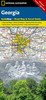


Georgia
Georgia at 1:600, 000 on an indexed road map from the Kiev-based Kartografia, with place names shown in the Cyrillic alphabet (selected locations also in the Georgian script) and a map legend in Ukrainian.The map provides good presentation of the country’s topography through relief shading and plenty of spot heights, plus names of peaks and mountain ranges, and boundaries of national parks. Road network is graded into six types, including country tracks, shows locations of petrol stations and border crossings and gives distances on main routes. Railway lines and coastal ferry connections are included and local airports are marked. The map also indicates locations with tourist accommodation.All place names are in the Cyrillic alphabet with names of selected towns and geographic
features also shown in the Georgian script. The map indicates the borders of Abkhazia and South Ossetia and within those two regions gives alternative local names for selected towns. The road network does not indicate if transit across those borders is possible. The map is indexed and has latitude and longitude lines at 1° intervals. Map legend is in Ukrainian only. Also provided is a distance table.IMPORTANT - PLEASE NOTE BEFORE ORDERING: supplies of all titles published in the Ukraine are irregular and we cannot guarantee a firm delivery time. When a title is out of stock, it may be advisable to choose an alternative publication.
features also shown in the Georgian script. The map indicates the borders of Abkhazia and South Ossetia and within those two regions gives alternative local names for selected towns. The road network does not indicate if transit across those borders is possible. The map is indexed and has latitude and longitude lines at 1° intervals. Map legend is in Ukrainian only. Also provided is a distance table.IMPORTANT - PLEASE NOTE BEFORE ORDERING: supplies of all titles published in the Ukraine are irregular and we cannot guarantee a firm delivery time. When a title is out of stock, it may be advisable to choose an alternative publication.
Product Description
Reviews/Comments
Add New
Vouchers
No voucher codes found.
Do you know a voucher code for this product or supplier? Add it to Insights for others to use.
Do you know a voucher code for this product or supplier? Add it to Insights for others to use.
 Denmark