
 United Kingdom
 France
 Germany
 Netherlands
 Sweden
 USA
USA
 Italy
Italy
 Spain
Spain
More From Contributor


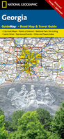
Georgia
Georgia at 1:610, 000 an on indexed map from ITMB with a street plan of central Tbilisi and a list of architectural monuments of special interest. Bold altitude colouring shows the topography, with names of mountain ranges, peaks or spot heights, and opening times of mountain passes marked along the roads. National parks and nature reserves are highlighted.Road network includes selected country tracks, gives driving distances on main routes and locations of petrol stations. Railway lines and ferry routes along the Black Sea are included. Symbols highlight various places of interest, including religious and archaeological sites, beaches, recreational areas, etc. Place names are given in Latin alphabet. Latitude and longitude lines are drawn at 1
Product Description
Reviews/Comments
Add New
Intelligent Comparison
Archived Product
Georgia Stanfords
£9.95
Archived Product
Georgia Stanfords
£8.50
Archived Product
Georgia Stanfords
£5.95
Archived Product
Georgia Stanfords
£6.99
Archived Product
Georgia Stanfords
£9.50
Archived Product

Georgia Stanfords
£17.99
Archived Product
Georgia Stanfords
£5.99
Archived Product

Gloria Stanfords
£8.99
Vouchers
No voucher codes found.
Do you know a voucher code for this product or supplier? Add it to Insights for others to use.
Do you know a voucher code for this product or supplier? Add it to Insights for others to use.
 Denmark