
 United Kingdom
 France
 Germany
 Netherlands
 Sweden
 USA
USA
 Italy
Italy
 Spain
Spain
More From Contributor


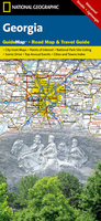
Georgia
Georgia at 1:500, 000 on a double-sided road map from the Tbilisi-based Geoland, showing a large number of small villages and highlighting various places of interest. Topography is shown by relief shading with spot heights, plus graphics and colouring for wetlands, salt lakes, glaciers, and different type of vegetation/land use (forests, orchards, plantations). National parks and protected areas are highlighted.Road network includes unpaved local roads, cart tracks and forestry roads. Railways are shown with stations and indicate narrow gauge lines. Local airports and Black Sea ports are marked. A range of symbols highlight various places of interest including archaeological sites, Tusheti and Svaneti towers, cave towns, beaches, etc.Also marked are oil pipelines from
Azerbaijan to the Black Sea, Turkey and Armenia. The map shows internal administrative divisions into provinces, including Abkhazia and South Ossetia, and city symbols indicate their administrative status. All place names are shown in Latin alphabet only. The map has latitude and longitude lines are drawn at 15
Azerbaijan to the Black Sea, Turkey and Armenia. The map shows internal administrative divisions into provinces, including Abkhazia and South Ossetia, and city symbols indicate their administrative status. All place names are shown in Latin alphabet only. The map has latitude and longitude lines are drawn at 15
Product Description
Reviews/Comments
Add New
Intelligent Comparison
Archived Product
Georgia Stanfords
£9.95
Archived Product
Georgia Stanfords
£8.50
Archived Product
Georgia Stanfords
£5.95
Archived Product
Georgia Stanfords
£6.99
Archived Product
Georgia Stanfords
£9.50
Archived Product
Georgia Stanfords
£17.99
Archived Product
Georgia Stanfords
£5.99
Archived Product
Gloria Stanfords
£8.99
Vouchers
No voucher codes found.
Do you know a voucher code for this product or supplier? Add it to Insights for others to use.
Do you know a voucher code for this product or supplier? Add it to Insights for others to use.
 Denmark