
 United Kingdom
 France
 Germany
 Netherlands
 Sweden
 USA
USA
 Italy
Italy
 Spain
Spain
More From Contributor

Ecuador F&B
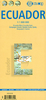
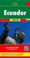
Ecuador on a large map at 1:800, 000 from Freytag & Berndt with bold relief shading and colouring providing good representation of the country’s topography. A large inset shows the Galapagos at the same scale.In addition to the relief shading, graphics show salt marshes, swamps and deserts, with spot heights and names of various mountain ranges, etc. Where appropriate, peak names indicate active volcanoes. National parks and other protected areas are prominently highlighted. Road network includes selected local tracks, shows locations of fuel supplies and border crossings, and gives driving distances on main routes. The course of the Pan American Highway is prominently highlighted as a tourist route. Railway lines are included and domestic airports are marked. The map also shows
internal administrative boundaries with names of the provinces, as well as oil wells and pipelines. Various places of interest are prominently highlighted by icons. Latitude and longitude lines are drawn at intervals of 1°. The index is on the reverse. Multilingual legend includes English.A large inset covers the Galapagos at 1:800, 000, clearly showing the island’s volcanic structures, naming various bays, canals, etc., and highlighting places of interest, etc.Place names, especially on the map of mainland Ecuador, are shown in larger print size than usually found on similar maps.
internal administrative boundaries with names of the provinces, as well as oil wells and pipelines. Various places of interest are prominently highlighted by icons. Latitude and longitude lines are drawn at intervals of 1°. The index is on the reverse. Multilingual legend includes English.A large inset covers the Galapagos at 1:800, 000, clearly showing the island’s volcanic structures, naming various bays, canals, etc., and highlighting places of interest, etc.Place names, especially on the map of mainland Ecuador, are shown in larger print size than usually found on similar maps.

Product Description
Reviews/Comments
Add New
Vouchers
No voucher codes found.
Do you know a voucher code for this product or supplier? Add it to Insights for others to use.
Do you know a voucher code for this product or supplier? Add it to Insights for others to use.
 Denmark