More From Contributor
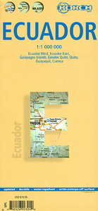
£12.79
Ecuador (including the Galapagos Islands) in the Countries, Regions & Cities series from Rough Guides; comprehensively detailed guidebooks specifically designed for independent travellers & serving a range of worldwide destinations. Widely recognised for their free editorial style, Rough Guide authors are allowed to express their personal opinions on a range of subjects. Although sometimes controversial, this editorial stance allows readers to experience more detailed & personal takes on each destination, a feature often more limited in other guidebooks. Cultural & historical nuances are explored in significant depth throughout the text & descriptions on the ambience of individual settings alongside personal recommendations, particularly in cities, are notably prevalent. Each Rough Guide in the Countries, Regions & Cities series has a similar layout. A ...
Archived Product
£6.95
Culture Smart! Ecuador provides essential information on attitudes, beliefs & behaviour in the Ecuador, ensuring that you arrive at your destination aware of basic manners, common courtesies, & sensitive issues. This concise guide will tell you what ...
Archived Product
£9.99
Ecuador at 1:750:000 in a series of Adventure maps from the National Geographic Society with cartography provided by Reise Know-How. The map is double-sided & printed on light waterproof & tear-resistant plastic paper. The Galapagos Islands, shown as an inset, are presented at the same scale as the main map. Cartographic information provided by Reise Know-How has been adjusted to follow the house style of the NGS Adventure series with greater emphasis on the country’s topography. Altitude colouring in broader bands has been replaced here by contours at 200m intervals. Boundaries of national parks & other protected areas are very prominently highlighted. Road network

Includes::
unsurfaced local roads & selected 4WD tracks. Distances are marked on main routes. Railway lines are included & local airports are marked. Internal administrative boundaries are shown with names of the provinces. Symbols indicate numerous places of interest, including UNESCO world heritage sites, archaeological remains, beaches & surfing sites, caves of particular interest, etc. The map has a latitude & longitude grid at intervals of 30’ & an extensive index of localities. Overall, the NGS map presents a more vivid picture of the country’s topography, whilst the original RK-H version provides clearer information for touring the country by road or rail.PLEASE NOTE: to ensure regular supplies & faster delivery to our customers we keep this title in regular stock in its Reise Know-How edition. The NGS version can be ordered on request.

...
Archived Product
£11.50
Ecuador at 1:650, 000 on an indexed, waterproof & tear-resistant road map with topographic & tourist information, published by Reise Know-How as part of their highly acclaimed World Mapping Project. The map is double-sided, with a generous overlap between the sides, to provide the best balance between a good scale & a convenient size sheet. The Galapagos Islands are included as an inset at 1:1, 000, 000. The country’s topography is presented by altitude colouring with contours, spot heights, mountain passes & names of mountain ranges – active volcanoes are highlighted. The map also shows mangroves, swamps, & seasonal rivers & lakes. Internal administrative boundaries are shown with names of the provinces. Road network indicates unsurfaced local roads & 4WD tracks, gives driving distances on main roads, plus locations of petrol station & border crossings. Railway lines are included & local airfields are marked. Symbols highlight various places of interest, including national parks & protected areas, UNESCO world heritage sites, churches & archaeological sites, campsites, beaches & diving or surfing locations, etc. Oil well & pipelines are also marked. The map has a latitude & longitude grid at intervals of 30’ & an extensive index of localities. Map legend

Includes::
English.

...
Archived Product
£16.99
Lonely Planet’s Ecuador & the Galapagos Islands is your passport to the most relevant, up-to-date advice on what to see & skip, & what hidden discoveries await you. Delve into the past in Quito’s vibrant Centro Historico, hike around Cotopaxi for million-dollar views, & spot blue-footed boobies & red-billed tropicbirds in Punta Suarez – all with your trusted travel companion. Get to the heart of Ecuador & the Galapagos Islands & begin your journey now! Inside Lonely Planet’s Ecuador & the Galapagos Islands:- Colour maps & images throughout- Highlights & itineraries help you tailor your trip to your personal needs & interests- Insider tips to save time & money & get around like a local, avoiding crowds & trouble spots- Essential info at your fingertips
- hours of operation, phone numbers, websites, transit tips, prices- Honest reviews for all budgets
- eating, sleeping, sightseeing, going out, shopping, hidden gems that most guidebooks miss- Cultural insights provide a richer, more rewarding travel experience
- covering history, people, music, landscapes, wildlife, cuisine, politics- Covers Quito, Northern Highlands, Central Highlands, Cuenca & the Southern Highlands, The Oriente, North Coast & Lowlands, South Coast, The Galapagos Islandse Book

Features:
(Best viewed on tablet devices & smartphones)- Downloadable PDF & offline maps prevent roaming & data charges- Effortlessly navigate & jump between maps & reviews- Add notes to personalise your guidebook experience- Seamlessly flip between pages- Bookmarks & speedy search capabilities get you to key pages in a flash- Embedded links to recommendations` websites- Zoom-in maps & images- Inbuilt dictionary for quick referencing


...
Archived Product
£12.99
Ecuador in Marshall Cavendish's Culture Shock! Series; comprising a range of guides that inform visitors of the finer points & details relating to social etiquette, traditions & customs; bringing visitors to a sensitive yet substantial understanding of the country or city in question. The series targets those who are planning long stays in the destination or extended periods of residence. The guides are written by authors who have experienced the joys & pitfalls of cultural adaptation, & so are ideally placed to provide informative & relevant advice. Each title contains insights into local culture & traditions, guidance on adapting to the local environment, linguistic help & lots of general advice about local culture & idiosyncrasies to help prepare readers for their visit. Each title is structured similarly, beginning with the first impressions a visitor might expect to have. The guides aim to help readers understand the local culture through first appreciating the motivations, beliefs & attitudes of the local people. Practical advice on settling in is provided, with focused sections on accommodation, utilities, health, education & telecommunications. There is also extensive information on the destination ...
Archived Product
£10.99
Ecuador on a large map at 1:800, 000 from Freytag & Berndt with bold relief shading & colouring providing good representation of the country’s topography. A large inset shows the Galapagos at the same scale. In addition to the relief shading, graphics show salt marshes, swamps & deserts, with spot heights & names of various mountain ranges, etc. Where appropriate, peak names indicate active volcanoes. National parks & other protected areas are prominently highlighted. Road network

Includes::
selected local tracks, shows locations of fuel supplies & border crossings, & gives driving distances on main routes. The course of the Pan American Highway is prominently highlighted as a tourist route. Railway lines are included & domestic airports are marked. The map also shows internal administrative boundaries with names of the provinces, as well as oil wells & pipelines. Various places of interest are prominently highlighted by icons. Latitude & longitude lines are drawn at intervals of 1°. The index is on the reverse. Multilingual legend

Includes::
English.A large inset covers the Galapagos at 1:800, 000, clearly showing the island’s volcanic structures, naming various bays, canals, etc., & highlighting places of interest, etc. Place names, especially on the map of mainland Ecuador, are shown in larger print size than usually found on similar maps.


...
Archived Product
£11.99
Seasoned travelers Julian Smith & Jean Brown lead travelers to unique, off-the-beaten-path adventures in Ecuador, from riding the train through the steep switchbacks of the famous Nariz del Diablo (Devil's Nose) to enjoying some of the best diving in the world off of the Galpagos Islands. Smith & Brown include several trip strategies that cater to the diverse interests of travelers, such as a Culture & History Tour & Outdoor Adventure Tour. Complete with information on exploring the colonial architecture of Quito's Old Town & climbing volcanoes in Sangay National Park, Moon Ecuador gives travelers the tools they need to create a more personal & memorable experience. ...
Archived Product
£7.99
With spectacular colonial architecture, dramatic landscapes & unique wildlife Ecuador is one of the most popular tourist destinations in South America. However rising activism & controversy over the impact of oil companies in the Jungle mean that this is a nation with an uncertain future. About this series: Given the turbulent history of many Central American & Latin American countries, travellers need as much information as they can get in order make the most of a visit. These illustrated titles offer up-to-date coverage of the main historical, economic, political, social & the environmental issues affecting a country. Published by the Latin America Bureau, an independent research group working to broaden public understanding of issues of human rights & social & economic justice in Latin America & the Caribbean. ...
Archived Product
£9.99
Ecuador at 1:660, 000 an indexed, double-sided map from ITMB printed on light, waterproof & tear-resistant synthetic paper. The map has altitude coluring to show the topography, plus street plans of Quito & Guayaquil, & an enlargement of the Quito region with Otavalo & several of the country’s volcanoes including Cotopaxi & Cayambe. The map is double-sided, dividing the country north/south with a good overlap between the sides. Relief is shown by altitude tinting & spot heights for peaks & volcanoes. Glaciers, swamp areas, national parks & reserves are marked. Road information indicates paved & unpaved secondary roads &

Includes::
season roads & selected tracks. Intermediate driving distances shown on main routes & locations of petrol stations are marked. Railway lines are included; local airports & in more remote areas landing strips are marked. The map also shows internal administrative boundaries with names of the provinces. Symbols highlight various places of interest including active/inactive volcanoes, thermal springs, national parks & nature reserves, bird watching sites, beaches, diving sites, etc. Latitude & longitude lines are drawn at 1° intervals. Each side has a separate index. Two insets provide clear street plans of Quito’s most visited areas: the Old Town & the Mariscal district. Both show public transport routes & various places of interest & facilities. A small, more basic street plan shows Guayaquil. Also provided is an enlargement of the Quito region extending north to Otavalo & Ibarra, & south to Latacunga. The region’s national parks & its active volcanoes, including Cotopaxi & Cayambe are highlighted.

...
Archived Product

Ecuador Borch

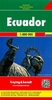
Ecuador at 1:1, 000, 000 on a laminated and waterproof tourist map from Borch with plans of central Quito, Guayaquil, and Cuenca, an enlargement for the Quito conurbation and a map of the Galapagos Islands.The main map covers the bulk of the country at 1:1, 000, 000, with the eastern part on the reverse at 1:2, 000, 000. Topography is shown by relief shading and spot heights. The map shows the country’s road network and highlights national parks and protected areas, numerous beaches and other places of interest. Latitude and longitude lines are marked at 30’ intervals on the main map and at 1° in the eastern part.An enlargement covers Gran Quito at 1:100, 000, showing access to the international airport, with a street plan of the central part of the capital at 1:20, 000. Two
more street plans show the centres of Guayaquil and Cuenca, highlighting local landmarks and attractions and selected accommodation. Also included is a map of the Galapagos Islands (1:1, 300, 000) highlighting places of interest and sites for snorkeling and scuba diving. All the maps and the street plans are indexed with lists of locations/streets, beaches, places of interest, etc. Multilingual map legend includes English.
RIP - This product is no longer available on our network. It was last seen on 25.09.2019

This page now acts as a permanent archive for this product. Add more information using the comments box below to ensure it can still be found by future generations.

Use our search facility to see if it is available from an alternative contributor.
  • Availability: Out Of Stock
  • Supplier: Stanfords
  • SKU: 9783866093249
Availability: In Stock
£9.99

Product Description

Ecuador at 1:1, 000, 000 on a laminated & waterproof tourist map from Borch with plans of central Quito, Guayaquil, & Cuenca, an enlargement for the Quito conurbation & a map of the Galapagos Islands. The main map covers the bulk of the country at 1:1, 000, 000, with the eastern part on the reverse at 1:2, 000, 000. Topography is shown by relief shading & spot heights. The map shows the country’s road network & highlights national parks & protected areas, numerous beaches & other places of interest. Latitude & longitude lines are marked at 30’ intervals on the main map & at 1° in the eastern part. An enlargement covers Gran Quito at 1:100, 000, showing access to the international airport, with a street plan of the central part of the capital at 1:20, 000. Two more street plans show the centres of Guayaquil & Cuenca, highlighting local landmarks & attractions & selected accommodation. Also included is a map of the Galapagos Islands (1:1, 300, 000) highlighting places of interest & sites for snorkeling & scuba diving. All the maps & the street plans are indexed with lists of locations/streets, beaches, places of interest, etc. Multilingual map legend

Includes::
English.

Reviews/Comments

Add New

Price History

Vouchers

No voucher codes found.
Do you know a voucher code for this product or supplier? Add it to Insights for others to use.

Facebook

Jargon Buster

Ecuador - A country in South America next to the Pacific Ocean
Waterproof - Resistant to water, usualy specified by depth in metres
Network - A link and communication between things. Often computers or people.
Road - a manmade lane or a path that is used to speed up travel.
Accommodation - A room in which someone can live in, for example in a hotel
Laminated - A thin layer of plastic that gives a coating and shine to a material.

Supplier Information

Stanfords
Stanfords was established in 1853 and opened their iconic Covent Garden flagship store in 1901. They have become the top retailer of maps, travel books and accessories in the UK and arguably offer the largest selection of maps and travel books worldwide. Famous names such as Captain Robert Falcon Scott, Ranulph Fiennes and Michael Palin have purchased from Stanfords. They now have a shop in Bristol and both stores together with other venues operate a calendar of events including talks, book signings and exhibitions. As a specialist map retailer, the map selection is comprehensive and includes road maps, street maps and walking maps from worldwide destinations, as well as a selection of world atlases and wall maps. Books include travel guides and travel literature. Stanfords also stock globes, from miniatures made of blue marble to magnificent floor-standing globes. The website features a selection of interesting articles on travel topics.
Page Updated: 2023-11-12 20:15:36

Community Generated Product Tags

Oh No! The productWIKI community hasn't generated any tags for this product yet!
Menu