
 United Kingdom
 France
 Germany
 Netherlands
 Sweden
 USA
USA
 Italy
Italy
 Spain
Spain
More From Contributor


Europe Borch
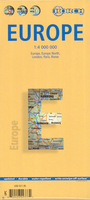
Europe on an indexed road map from Borch at 1:4, 000, 000, with large street plans of central London, Paris and Rome highlighting these cities’ 15 outstanding sights. Laminated and waterproof, the map can be annotated with suitable markers without damaging its surface.On one side is a road map of Europe at 1:4, 000, 000 extending north to Oslo/Stockholm/Tallinn and east to Moscow/Odessa/Istanbul. The map shows the Continent’s network of motorways for long-distance route planning, with the connecting national and other main roads. Road numbering gives both the pan-European E route numbers, and the national road numbers. National boundaries are marked, with relief shading showing main geographical features such as mountain chains, plains, etc. The map has latitude lines at
intervals of 1°, with longitude at 2°. The index is arranged by country.On the reverse a map at 1:5, 000, 000 shows the Scandinavian countries, extending east to St. Petersburg. Three further large insets provide street plans of central London, Paris and Rome, each clearly showing places of interest, with 15 main sights prominently highlighted. Each city also has a road map of its environs showing road and rail access to its principal airports.
intervals of 1°, with longitude at 2°. The index is arranged by country.On the reverse a map at 1:5, 000, 000 shows the Scandinavian countries, extending east to St. Petersburg. Three further large insets provide street plans of central London, Paris and Rome, each clearly showing places of interest, with 15 main sights prominently highlighted. Each city also has a road map of its environs showing road and rail access to its principal airports.

Product Description
Reviews/Comments
Add New
Vouchers
No voucher codes found.
Do you know a voucher code for this product or supplier? Add it to Insights for others to use.
Do you know a voucher code for this product or supplier? Add it to Insights for others to use.
 Denmark