
 United Kingdom
 France
 Germany
 Netherlands
 Sweden
 USA
USA
 Italy
Italy
 Spain
Spain
More From Contributor


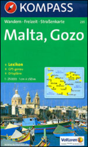
Malta - Gozo Kompass 235
Detailed contoured map of Malta, Gozo and Comino, with an overprint highlighting numerous hiking paths and places of interest, plus street plans of Valetta, Sliema, Rabat and Mdina, and Bugibba. Contours at 10m intervals with relief shading show the topography of the islands. Road network gives driving distances on main routes and locations of car parks. Extensive overprint highlights numerous hiking routes, indicating steep sections and trails requiring climbing experience. Symbols mark various places of interest including castles and churches, museums, sport and recreational facilities, campsites, beaches, surfing and diving sites, marinas, etc. The map has a 1km UTM grid.Indexed street plans of cover the old part of Valetta, Sliema, Rabat and Mdina, and Bugibba,
showing main places of interest. PLEASE NOTE: the map has a comprehensive, multilingual legend which includes English. The accompanying booklet describing main places of interest is in German only and is not available in an English edition.
showing main places of interest. PLEASE NOTE: the map has a comprehensive, multilingual legend which includes English. The accompanying booklet describing main places of interest is in German only and is not available in an English edition.

Product Description
Reviews/Comments
Add New
Vouchers
No voucher codes found.
Do you know a voucher code for this product or supplier? Add it to Insights for others to use.
Do you know a voucher code for this product or supplier? Add it to Insights for others to use.
 Denmark