
 United Kingdom
 France
 Germany
 Netherlands
 Sweden
 USA
USA
 Italy
Italy
 Spain
Spain
More From Contributor


Madeira Walks: Volume 2: Challenging Trails & High Altitude Routes
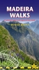
As a walker`s paradise, Madeira has it all - majestic mountains, rugged coastline, ancient forests, a unique levada network and verdant flora; easy to see why so many walkers return year after year. In 2015 Madeira was voted the ”World`s Best Island Destination” by the World Travel Awards the final accolade from the previous two years when it was voted ”Europe`s Leading Island Destination”. Quite an achievement, brought about largely by the substantial EU investment over the past decade in the improvement and development of the island`s infrastructure and facilities. One of the initiatives focused on improving and creating new walking trails which has resulted in Madeira now being regarded as one of Europe`s top hiking destinations.To date, around thirty routes on Madeira
have been designated Recommended Trails for Hikers and currently our guides are the only publications to include all these trails. We have also taken on board the many comments received from walkers over the last few years.Taking all the above into account, we`ve reorganized our books into a compendium of two editions; Madeira Walks: Volume One, Leisure Trails (published May 2015) included the shorter and easier trails whilst Madeira Walks: Volume Two covers 40 more challenging and high altitude routes. There`s a good balance including coastal routes, forest trails, moorland and mountain pathways and levada walks although the terrain varies greatly. We`ve introduced a number of new routes whilst continuing to include our favourite `off the beaten track` trails, so regardless of
fitness, age or ability, there`s something for everyone. Both books are arranged by geographic area, then by exertion rating under each heading. All the trails have been surveyed and mapped using GPS satellite navigation. The authors and their co-walkers have walked all these routes and continue to revisit as many as possible, especially those we believe could be subject to change; this ensures accuracy and up to date information for hikers. Clear descriptions guide the walker both to the starting point and throughout the routes, with gradings, distances, timings and altitudes all symbolized.Whilst distances vary considerably, many of the routes have steep ascents or descents and a few are subject to some extremely precipitous sections. Some information on flora and fauna is also
included, while references to places of interest give readers a sense of the culture and history around these trails. Map sections were developed from the Madeira Tour & Trail Map, by far the most up to date and best-selling map on the island. In addition to the walking trails, viewing platforms (miradouros) are found around the island providing strategic positions for taking in the most stunning views. Barbeque and picnic areas are also positioned in picturesque locations around the island.
Product Description
Reviews/Comments
Add New
Vouchers
No voucher codes found.
Do you know a voucher code for this product or supplier? Add it to Insights for others to use.
Do you know a voucher code for this product or supplier? Add it to Insights for others to use.
 Denmark