
 United Kingdom
 France
 Germany
 Netherlands
 Sweden
 USA
USA
 Italy
Italy
 Spain
Spain
More From Contributor


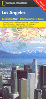
Los Angeles
The National Geographic map of Los Angeles at 1:204, 000 is a durable waterproof road map of the greater Los Angeles area, with several enlargements for top areas, designed for tourism. The map clearly shows the city freeway and tollway network, main local roads, and metro connections, and each of the 80 smaller cities and districts that together make up the Los Angeles conurbation are shaded. The map also includes general tourist background info on the reverse, and transport advice on how to get around the city.The total area of coverage is from Laguna Hills, Irvine and Newport Beach in the south-east, to the Santa Monica Mountains in the north-west. Two small insets give slightly higher detail of Anaheim and Long BeachTwo other enlargements provide higher-scale mapping of key
areas: *Downtown Los Angeles* at 1:30, 000, showing approximately 8.5x8.5km (5x5 miles) centred on Little Tokyo, and *Westside* at 1:78, 000, including Santa Monica, Beverly Hills, Hollywood, Universal City and part of the Santa Monica Mountains National Recreation Area (this overlaps with the Downtown LA map`s western half). These maps provide better - but not comprehensive - street detail, and have key points of tourist interest highlighted, including top attractions, notable buildings, hotels and information points.This map is printed on a surprisingly strong rip-proof, waterproof paper.
areas: *Downtown Los Angeles* at 1:30, 000, showing approximately 8.5x8.5km (5x5 miles) centred on Little Tokyo, and *Westside* at 1:78, 000, including Santa Monica, Beverly Hills, Hollywood, Universal City and part of the Santa Monica Mountains National Recreation Area (this overlaps with the Downtown LA map`s western half). These maps provide better - but not comprehensive - street detail, and have key points of tourist interest highlighted, including top attractions, notable buildings, hotels and information points.This map is printed on a surprisingly strong rip-proof, waterproof paper.

Product Description
Reviews/Comments
Add New
Intelligent Comparison
Archived Product
Los Angeles Stanfords
£4.99
Archived Product
Los Angeles Stanfords
£3.99
Archived Product
Los Angeles Stanfords
£4.99
Archived Product
Los Angeles Stanfords
£4.99
Archived Product

Los Angeles Stanfords
£7.99
Archived Product

Los Angeles Noir Stanfords
£9.99
Archived Product

Los Angeles Borch Stanfords
£8.99
Archived Product

Los Angeles Noir 2 Stanfords
£9.99
Vouchers
No voucher codes found.
Do you know a voucher code for this product or supplier? Add it to Insights for others to use.
Do you know a voucher code for this product or supplier? Add it to Insights for others to use.
 Denmark