
 United Kingdom
 France
 Germany
 Netherlands
 Sweden
 USA
USA
 Italy
Italy
 Spain
Spain
More From Contributor


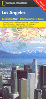
Los Angeles Borch
Laminated and waterproof map for visitors to Los Angeles, combining a selection of street plans and a road map to cover the LA conurbation as a whole plus its most visited parts in greater detail. An overview street plan of the city at 1:60, 000 extends from Santa Monica and the International Airport inland to Pasadena and San Gabriel, naming the districts and mains streets, highlighting the city’s highway network, and indicating Metrorail and MetroLink stations. More detailed street plans are provided for the Downtown area (1:17, 000), Hollywood (1:15, 000) and Santa Monica - Venice waterfront (1:20, 000). All plans highlight numerous places of interest, selected hotels, car parks, etc. and show one way streets and metro stationsA road map at 1:225, 000 shows the LA conurbation
from Malibu along the coast to Laguna Beach and inland to San Bernardino, highlighting highways and indicating metro connections. All the plans and the road map are indexed with lists of streets/localities, sights, hotels, etc. Also included are a diagram of the Metrorail lines, a plan of the international airport, an administrative map of USA with time zones, a list of top 30 sights, and information on the city’s climate.
from Malibu along the coast to Laguna Beach and inland to San Bernardino, highlighting highways and indicating metro connections. All the plans and the road map are indexed with lists of streets/localities, sights, hotels, etc. Also included are a diagram of the Metrorail lines, a plan of the international airport, an administrative map of USA with time zones, a list of top 30 sights, and information on the city’s climate.

Product Description
Reviews/Comments
Add New
Intelligent Comparison
Archived Product

Los Angeles Noir Stanfords
£9.99
Archived Product

Los Angeles Noir 2 Stanfords
£9.99
Archived Product
Los Angeles Stanfords
£8.95
Archived Product
Los Angeles Stanfords
£6.99
Archived Product
Los Angeles Stanfords
£4.99
Archived Product
Los Angeles Stanfords
£3.99
Archived Product
Los Angeles Stanfords
£4.99
Archived Product
Los Angeles Stanfords
£4.99
Vouchers
No voucher codes found.
Do you know a voucher code for this product or supplier? Add it to Insights for others to use.
Do you know a voucher code for this product or supplier? Add it to Insights for others to use.
 Denmark