More From Contributor

£12.99
Since a bloodless coup in 1969, Libya has become synonymous with Mu'ammar al-Qaddafi, the charismatic leader Nelson Mandela dubbed one of the revolutionary icons of our time. However, falling prey to empire-builders from the ancient Greeks to Mussolini's Italy, Libya was embroiled in controversy long before his meteoric rise to power. Skillfully navigating the nation's history, Ronald Bruce St John explores Libya's struggle to establish its political & economic identity. From the infamous Lockerbie bombing to Qaddafi's astonishing return to the international stage, this is a thoughtful & engrossing introduction to this turbulent land on the cusp of Africa & the Middle East. ...
Archived Product
£10.99
Skilfully navigating Libya`s eventful past, this fully updated edition of Ronald Bruce St John`s authoritative work


...
Archived Product
£13.50
Libya Geographical Edition Wall Map at 1:1.750, 000 from Gizi Map, size 97 x 87cm (38” x 34” approx), with bold altitude colouring to show its topography, oil & gas wells & pipelines, water aqueducts, ancients sites & other places of interest, etc. Names of larger towns & selected smaller locations, as well as of many topographic features are also shown in Arabic. The map provides a very fine presentation of the country’s geography through bold altitude colouring & graphics for sandy or stone deserts, swamps, salt flats, oasis, & water wells, plus numerous spot heights & plenty of names of mountain ranges, wadis, etc. Road network shows desert tracks & gives distances on main routes. Railway lines are included & domestic airports/aerodromes are marked. The map also shows oil or gas wells & pipelines, water aqueducts & boundaries of administrative provinces. Symbols indicate locations with campsites or youth hostels, various places of interest including archaeological sites & natural curiosities, etc. Latitude & longitude lines are drawn at 1° intervals. The index is next to the map. Map legend

Includes::
English & Arabic. Also provided is a distance table.PLEASE NOTE: this wall map is also available in a road edition with altitude colouring replaced by relief shading to make the road network stand out better from the background – all other information is the same. Both versions are also available folded.

...
Archived Product
£9.99
Libya at 1:1, 750, 000 on an indexed map from Gizi Map with bold altitude colouring to show its physical geography, oil & gas wells & pipelines, water aqueducts, ancients sites & other places of interest, etc. Names of larger towns & selected smaller locations, as well as of many topographic features are also shown in Arabic. The map provides a very fine presentation of the country’s geography through bold altitude colouring & graphics for sandy or stone deserts, swamps, salt flats, oasis, & water wells, plus numerous spot heights & plenty of names of mountain ranges, wadis, etc. Road network shows desert tracks & gives distances on main routes. Railway lines are included & domestic airports/aerodromes are marked. The map also shows oil or gas wells & pipelines, water aqueducts & boundaries of administrative provinces. Symbols indicate locations with campsites or youth hostels, various places of interest including archaeological sites & natural curiosities, etc. Latitude & longitude lines are drawn at 1° intervals. The index is next to the map. Map legend

Includes::
English & Arabic. Also provided is a distance table.PLEASE NOTE: this map is also available in a road edition with altitude colouring replaced by relief shading to make the road network stand out better from the background – all other information is the same. Both versions are also published as wall maps.

...
Archived Product
£5.99
Libya in the Pocket Guide series from Berlitz; a collection of handy, pocket-sized guides dedicated to an extensive range of cities, regions & countries worldwide. Written in narrative form, individual guides explore the history, main sights & attractions, food & drink, accommodation & local culture of the destination in detail. Each Berlitz pocket guide has a similar format, with colour-coded sections helping readers locate information quickly in addition to distinctive chapters exploring the city or region. An introduction outlines the destination for visitors & a section dedicated to 'A Brief History' actually explores the area in relative depth. A where to go chapter is organized by region & city & is written in prose form with references to individual sites highlighted in bold for clarity. There are also further suggestions on where & when to eat. Recommendations for leisure activities in the region, including sport, nightlife & shopping, are also provided & tailored accordingly for each destination. Handy travel tips are listed alphabetically in a dedicated section, providing practical guidance & helping visitors make the most of their stay. The main hotels, particularly for cities, are also listed in an accommodation section, offering a brief overview with approximate price bandings & relevant contact details. ...
Archived Product
£13.50
Libya Road Edition Wall Map at 1:1.750, 000 from Gizi Map, size 97 x 87cm (38” x 34” approx), with very fine presentation of its physical geography, oil & gas wells & pipelines, water aqueducts, ancients sites & other places of interest, etc. Names of larger towns & selected smaller locations, as well as of many topographic features are also shown in Arabic. The map provides a very fine presentation of the country’s geography through bold altitude colouring & graphics for sandy or stone deserts, swamps, salt flats, oasis, & water wells, plus numerous spot heights & plenty of names of mountain ranges, wadis, etc. Road network shows desert tracks & gives distances on main routes. Railway lines are included & domestic airports/aerodromes are marked. The map also shows oil or gas wells & pipelines, water aqueducts & boundaries of administrative provinces. Symbols indicate locations with campsites or youth hostels, various places of interest including archaeological sites & natural curiosities, etc. Latitude & longitude lines are drawn at 1° intervals. The index is next to the map. Map legend

Includes::
English & Arabic. Also provided is a distance table.PLEASE NOTE: this map is also available in a geographical edition with bold altitude colouring replacing relief shading – all other information is the same. Both versions are also available folded.

...
Archived Product
£9.99
Libya at 1:1, 750, 000 on an indexed road map from Gizi Map with exceptionally fine & detailed presentation of its physical geography, oil & gas wells & pipelines, water aqueducts, ancients sites & other places of interest, etc. Names of larger towns & selected smaller locations, as well as of many topographic features are also shown in Arabic. The map provides a very fine presentation of the country’s geography through relief shading & graphics for sandy or stone deserts, swamps, salt flats, oasis, & water wells, plus numerous spot heights & plenty of names of mountain ranges, wadis, etc. Road network shows desert tracks & gives distances on main routes. Railway lines are included & domestic airports/aerodromes are marked. The map also shows oil or gas wells & pipelines, water aqueducts & boundaries of administrative provinces. Symbols indicate locations with campsites or youth hostels, various places of interest including archaeological sites & natural curiosities, etc. Latitude & longitude lines are drawn at 1° intervals. The index is next to the map. Map legend

Includes::
English & Arabic. Also provided is a distance table.PLEASE NOTE: this map is also available in a geographical edition with bold altitude colouring instead of relief shading – all other information is the same. Both versions are also published as wall maps.

...
Archived Product
£12.99
Since Qaddafi`s ousting in 2011, Libya has been beset by instability & conflict. To understand the tumultuous state of the country today, one must look to its past. With great clarity & precision, renowned regional expert Ronald Bruce St John examines Libya`s long struggle to establish its political & economic identity amidst the interference of external actors keen to exploit the country`s strategic importance. This authoritative history spans the time of the early Phoenician & Greek settlements, colonization by Mussolini`s Italy, Qaddafi`s four decades of rule &, in this updated edition, the internal rivalries that have dominated the country in the aftermath of the Arab Spring. Essential reading for those seeking a greater understanding of this complex North African state, Libya: From Colony to Revolution is an insightful history, rich in detail & analysis. ...
Archived Product
£12.99
” Libyan Sands” is unmistakably the work of an Englishman, a modest, machine- & desert-loving young officer whose passionate amateur enthusiasm led to the exploration of the Egyptian western desert & the Libyan Sahara on the eve of the second world war. ...
Archived Product
£17.99
This is a new edition of English Heritage`s widely acclaimed study of that great British institution, the public house. First published in 2004, this was described as the best history of the pub available. Now updated & corrected, it offers a scholarly, yet accessible history of the origins of the pub & its development since medieval times. Alcoholic beverages have long formed a part of British culture & over the centuries the authorities have made strenuous efforts to control the form & operation of public drinking establishments (with varying degrees of success!). The Golden Age of pub-building was at the end of the nineteenth century & many of the finest examples are illustrated here. It was brought about by a combination of forces which are all explored
- the influence of the Temperance Movement, competition from rival forms of entertainment, & efforts on the part of magistrates & government to improve the pub stock. The book contains a stunning photographic survey of our pub heritage & lists most of the finest & interesting surviving examples. This new edition also explains the changes that have affected pubs, their culture & appearance during the past seven years.
...
Archived Product

Libya Reise Know-How

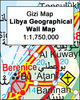
Indexed, waterproof and tear-resistant road map of Libya with topographic and tourist information, published by Reise Know-How as part of their highly acclaimed World Mapping Project. The map is double-sided to provide the best balance between a good scale and a convenient size sheet.Road and rail networks are easy to see on a clear base which shows the area’s topography by altitude colouring with contours, spot heights, mountain passes, and names of mountain ranges. The map also shows deserts, salt lakes and seasonal rivers. Internal administrative boundaries are shown with names of the provinces. Names of main towns are also given in Arabic script. Road network includes unsurfaced roads and seasonal tracks and indicates locations of fuel supplies. A wide range of symbols
highlight various places of interest, including national parks and protected areas, oasis and water wells, UNESCO world heritage sites, archaeological remains, campsites, caves, beaches, etc. Oil wells and pipelines are also marked, as well as the course of the “Great-Man-Made-River” project. The map has a latitude and longitude grid at intervals of 1° and an index of place names. Map legend includes English.
RIP - This product is no longer available on our network. It was last seen on 25.09.2019

This page now acts as a permanent archive for this product. Add more information using the comments box below to ensure it can still be found by future generations.

Use our search facility to see if it is available from an alternative contributor.
  • Availability: Out Of Stock
  • Supplier: Stanfords
  • SKU: 9783831770229
Availability: In Stock
£10.50

Product Description

Indexed, waterproof & tear-resistant road map of Libya with topographic & tourist information, published by Reise Know-How as part of their highly acclaimed World Mapping Project. The map is double-sided to provide the best balance between a good scale & a convenient size sheet. Road & rail networks are easy to see on a clear base which shows the area’s topography by altitude colouring with contours, spot heights, mountain passes, & names of mountain ranges. The map also shows deserts, salt lakes & seasonal rivers. Internal administrative boundaries are shown with names of the provinces. Names of main towns are also given in Arabic script. Road network

Includes::
unsurfaced roads & seasonal tracks & indicates locations of fuel supplies. A wide range of symbols highlight various places of interest, including national parks & protected areas, oasis & water wells, UNESCO world heritage sites, archaeological remains, campsites, caves, beaches, etc. Oil wells & pipelines are also marked, as well as the course of the “ Great-Man-Made-River” project. The map has a latitude & longitude grid at intervals of 1° & an index of place names. Map legend

Includes::
English.

Reviews/Comments

Add New

Price History

Vouchers

No voucher codes found.
Do you know a voucher code for this product or supplier? Add it to Insights for others to use.

Facebook

Jargon Buster

Oil - A hydrophobic liquid with high carbon and hydrogen content. Has many variations including; cooking oils, petrochemical oils, essential oils.
fuel - A material used to generate energy.
water - A chemical substance. Chemical formula H2O.
Waterproof - Resistant to water, usualy specified by depth in metres
World - A physical grouping, commonly used to describe earth and everything associated with ti
Size - is the measurement of how big an object is in space.
Network - A link and communication between things. Often computers or people.
Road - a manmade lane or a path that is used to speed up travel.
Resistant - Something that can repel against something.
Altitude - Something that can be quite high in relation to sea or ground level.
Wide - Something with a large width.
Balance - Something that is evenly weighted to keep something upright.
Convenient - Something that suits and fits well to other activities.

Supplier Information

Stanfords
Stanfords was established in 1853 and opened their iconic Covent Garden flagship store in 1901. They have become the top retailer of maps, travel books and accessories in the UK and arguably offer the largest selection of maps and travel books worldwide. Famous names such as Captain Robert Falcon Scott, Ranulph Fiennes and Michael Palin have purchased from Stanfords. They now have a shop in Bristol and both stores together with other venues operate a calendar of events including talks, book signings and exhibitions. As a specialist map retailer, the map selection is comprehensive and includes road maps, street maps and walking maps from worldwide destinations, as well as a selection of world atlases and wall maps. Books include travel guides and travel literature. Stanfords also stock globes, from miniatures made of blue marble to magnificent floor-standing globes. The website features a selection of interesting articles on travel topics.
Page Updated: 2023-11-12 20:15:36

Community Generated Product Tags

Oh No! The productWIKI community hasn't generated any tags for this product yet!
Menu