
 United Kingdom
 France
 Germany
 Netherlands
 Sweden
 USA
USA
 Italy
Italy
 Spain
Spain
More From Contributor

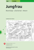

Jungfrau Region Winter Map
Jungfrau Region Winter Map from Hallwag presenting the area at 1:50, 000 with extensive information for ski and snowshoe tours, cross-country tracks, sledge tracks, winter hiking routes, tourist facilities, etc, printed on waterproof and tear-resistant synthetic paper. Coverage includes Grindelwald, Wengen, Lauterbrunnen, M
Product Description
Reviews/Comments
Add New
Intelligent Comparison
Archived Product

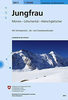
Jungfrau Region Tour Stanfords
£14.00
Vouchers
No voucher codes found.
Do you know a voucher code for this product or supplier? Add it to Insights for others to use.
Do you know a voucher code for this product or supplier? Add it to Insights for others to use.
 Denmark