
 United Kingdom
 France
 Germany
 Netherlands
 Sweden
 USA
USA
 Italy
Italy
 Spain
Spain
More From Contributor


Jerusalem F&B
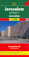
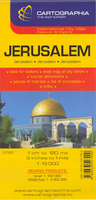
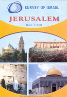
Large, general street plan of the city with a clear enlargement of the Old City at 1:4, 500. The main plan extends west to beyond the Jerusalem Forest and east to Mount of Olives. Coverage north/south is from Ramat Polin and Beit Khanina to Gilo. Public buildings a highlighted and symbols mark places of worships, monuments, etc. A large inset provides more detailed coverage of the Old City, indicating various places of worship and historical monuments, car parks, etc. All place names are in Roman alphabet only. Multilingual map legend included English and Hebrew.

Product Description
Reviews/Comments
Add New
Intelligent Comparison
Archived Product

Jerusalem Stanfords
£8.99
Archived Product
Jerusalem Stanfords
£7.99
Archived Product
Jerusalem Stanfords
£9.50
Archived Product
Jerusalem Stanfords
£13.50
Archived Product
Jerusalem Stanfords
£13.50
Archived Product
Jerusalem Stanfords
£10.39
Archived Product
Jerusalem Stanfords
£8.99
Archived Product

Jerusalem Stanfords
£27.00
Vouchers
No voucher codes found.
Do you know a voucher code for this product or supplier? Add it to Insights for others to use.
Do you know a voucher code for this product or supplier? Add it to Insights for others to use.
 Denmark