
 United Kingdom
 France
 Germany
 Netherlands
 Sweden
 USA
USA
 Italy
Italy
 Spain
Spain
More From Contributor


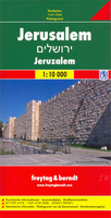
Jerusalem Borch
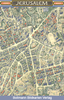
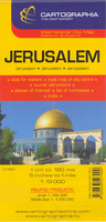
Excellent plan for visitors to the city: clear, indexed, laminated and waterproof, with a map of greater Jerusalem, plan of Bethlehem, a road map of central Israel and plenty of tourist information. The main street plan extends from the Mount of Olives across the Old City and the central districts to the Israel Museum and the Shrine of the Book, the Knesset, and the Hebrew University at Giv’at Ram. The map highlights numerous places of interest, places of worship of various denominations, selected hotels, one way streets, car parks and petrol stations, etc. The map of Greater Jerusalem at 1:30, 000 extends the coverage to include Yad Vashem, Mount Herzl and the Moskovia district.The map also includes annotated ground plans of the Holy Sepulchre Church and the Dome of the
Rock in the Old City, and a street plan of Bethlehem at 1:11, 000. A road map of central Israel at 1:400, 000, extending to the coast and, north/south, just beyond Hebron and Nablus, shows the road network with numerous places of interest and indicates areas under the Palestinian authority. All place names are in Roman alphabet, with alternative transliterations where appropriate. English names are used for places of interest. All the maps have indexes which include both streets/locations and the main sites, and 30 of the most interesting places worth visiting, both within the city itself and on the other maps, are highlighted and included on a list of Top30 Sights.
Rock in the Old City, and a street plan of Bethlehem at 1:11, 000. A road map of central Israel at 1:400, 000, extending to the coast and, north/south, just beyond Hebron and Nablus, shows the road network with numerous places of interest and indicates areas under the Palestinian authority. All place names are in Roman alphabet, with alternative transliterations where appropriate. English names are used for places of interest. All the maps have indexes which include both streets/locations and the main sites, and 30 of the most interesting places worth visiting, both within the city itself and on the other maps, are highlighted and included on a list of Top30 Sights.

Product Description
Reviews/Comments
Add New
Intelligent Comparison
Archived Product
Jerusalem F&B Stanfords
£9.99
Archived Product

Jerusalem Stanfords
£8.99
Archived Product
Jerusalem Stanfords
£7.99
Archived Product
Jerusalem Stanfords
£9.50
Archived Product
Jerusalem Stanfords
£13.50
Archived Product
Jerusalem Stanfords
£13.50
Archived Product
Jerusalem Stanfords
£10.39
Archived Product
Jerusalem Stanfords
£8.99
Vouchers
No voucher codes found.
Do you know a voucher code for this product or supplier? Add it to Insights for others to use.
Do you know a voucher code for this product or supplier? Add it to Insights for others to use.
 Denmark