
 United Kingdom
 France
 Germany
 Netherlands
 Sweden
 USA
USA
 Italy
Italy
 Spain
Spain
More From Contributor


Israel
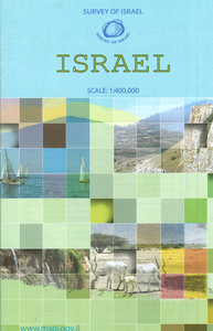
Overview map of the country from the Israeli national survey organization, with the Sinai Peninsula shown as an inset. The map indicates zones of Palestinian or joint Israeli - Palestinian authority, marks the course of the separation wall at the time of its publication in 2003, and shows various boundaries such as the cease-fire lines of 1967 and disengagement lines of 1974. Due to the scale of the map, the road network in the central part of the country is somewhat cluttered, but clearer on the Negev Desert and in the inset covering the Sinai Peninsula at 1:1, 600, 000. The map has a UTM grid, all place names are in Roman alphabet only and map legend is in English. Also included is a small political map of the whole of the Middle East.

Product Description
Reviews/Comments
Add New
Intelligent Comparison
Archived Product

Israel Stanfords
£10.50
Archived Product
Israel Stanfords
£9.50
Archived Product
Israel Stanfords
£8.50
Archived Product
Israel Stanfords
£16.99
Archived Product
Israel Stanfords
£4.99
Archived Product

Israel Stanfords
£15.99
Vouchers
No voucher codes found.
Do you know a voucher code for this product or supplier? Add it to Insights for others to use.
Do you know a voucher code for this product or supplier? Add it to Insights for others to use.
 Denmark