
 United Kingdom
 France
 Germany
 Netherlands
 Sweden
 USA
USA
 Italy
Italy
 Spain
Spain
More From Contributor


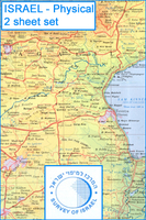
Israel Physical Map 2-Sheet Set
Physical map of the country on two sheets from the Israeli national survey organization. Altitude colouring, graded at 100m intervals to over 300m below the sea level, vividly shows the depression of the Jordan Valley and around the Dead Sea. The map indicates marshes, mudflats, sand dunes, perennial and dry wadis, etc., and gives plenty of names of geographical features. Cross stitching indicates areas of Palestinian control or joint responsibility and the course of the separation wall is indicated as it stood 2005 when the latest edition of this map was prepared. International boundaries show various demarcation lines.Road network is less clearly defined than on the publisher’s touring set and, similarly, this map includes less additional information on places of interest,
etc. The map has a 10km Israel survey grid with both old and new coordinates, plus margin ticks for latitude and longitude at 1’. Map legend is in English and all place names are shown in Roman alphabet. No index is provided.
etc. The map has a 10km Israel survey grid with both old and new coordinates, plus margin ticks for latitude and longitude at 1’. Map legend is in English and all place names are shown in Roman alphabet. No index is provided.

Product Description
Reviews/Comments
Add New
Intelligent Comparison
Archived Product
Russia Pysical Wall Map (2-sheet Set) Stanfords
£29.95
Vouchers
No voucher codes found.
Do you know a voucher code for this product or supplier? Add it to Insights for others to use.
Do you know a voucher code for this product or supplier? Add it to Insights for others to use.
 Denmark