More From Contributor
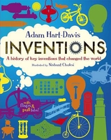
£6.99
Emotional Intelligence: A Practical Guide shows how you can improve your personal & professional relationships, your health, your children`s prospects & more. With exercises, case studies & useful tips, it helps you put the principles of EI into practice to achieve a happier, healthier life. STAY IN CONTROL with a greater understanding of yourself INFLUENCE OTHERS through assertive communication HELP YOUR CHILD AT SCHOOL by improving their concentration & behaviour IMPROVE YOUR PHYSICAL WELL-BEING by regulating your emotions ...
Archived Product
£9.99
What is time? The fifth-century philosopher St Augustine famously said that he knew what time is so long as no one asked him. Introducing Time dares go where Augustine would not. It traces the history of time from Augustine to Newton, Poincare, Einstein, & then back full circle to the idea that there is no time in quantum gravity. Is time a fourth dimension? Does the future exist? Is time travel possible? If so, does it threaten the work prospects of historians, as Stephen Hawking thinks? Why does time seem to pass in only one direction? Introducing Time presents these questions & others (many for the first time) in an easily accessible, lucid & engaging guide. ...
Archived Product
£36.95
Military topographic survey mapping with contours. These maps are designed primarily as flying charts for aircraft, but they are useful as general topographical maps where nothing else is available. Contours are shown in feet, with elevation colouring & spot heights. Towns, villages, major roads, railways & airports are shown (but please note that many of the smaller settlements are not named, & the road information is not necessarily up to date). Some air navigation information also appears on the map, such as radio beacons & restricted flying zones. Double-sided sheet. ...
Archived Product
£11.99
Wine is around 8, 000 years old but the wines that people buy & drink today are mostly quite new. Modern wine exists as the product of multiple revolutions
- scientific, industrial, social, even ideological. Though it has the same basic chemical substance as its ancient forebear, it is in every other respect very different. For many thousands of years, wine was a basic need. Contemporary wines taste unlike those from earlier eras & are valued in novel ways. Today it is a cultural choice & the reasons why millions of people choose it tells us as much about them as about the contents of the bottle or glass. In Inventing Wine, Paul Lukacs chronicles wine`s transformation from a source of sustenance to a consciously pursued pleasure, in the process offering a new way to view the present as well as the past.
...
Archived Product
£25.00
Alexander von Humboldt (1769-1859) is the great lost scientist: more things are named after him than anyone else. There are towns, rivers, mountain ranges, the ocean current that runs along the South American coast, there`s a penguin, a giant squid
- even the Mare Humboldtianum on the moon. His colourful adventures read like something out of a Boy`s Own story: Humboldt explored deep into the rainforest, climbed the world`s highest volcanoes & inspired princes & presidents, scientists & poets alike. Napoleon was jealous of him; Simon Bolivar`s revolution was fuelled by his ideas; Darwin set sail on the Beagle because of Humboldt; & Jules Verne`s Captain Nemo owned all his many books. He simply was, as one contemporary put it, `the greatest man since the Deluge`. Taking us on a fantastic voyage in his footsteps
- racing across anthrax-infected Russia or mapping tropical rivers alive with crocodiles
- Andrea Wulf shows why his life & ideas remain so important today. Humboldt predicted human-induced climate change as early as 1800, & The Invention of Nature traces his ideas as they go on to revolutionize & shape science, conservation, nature writing, politics, art & the theory of evolution. He wanted to know & understand everything & his way of thinking was so far ahead of his time that it`s only coming into its own now. Alexander von Humboldt really did invent the way we see nature.


...
Archived Product
£8.50
Invercargill & Southland region in a series of maps covering various districts of New Zeal&, with each title combining a detailed road map with street plans of local towns, all with road & street indexes. The maps are published in two formats: handy Pocket Maps or Pathfinders with, as the publishers put it “ Larger print so you don’t squint”. The road maps, typically around 1:175, 000
- 1:275, 000, show local roads & 4WD tracks. Main sightseeing routes across the country, such as the Pacific Road Highway or Thermal Explorer Highway, are identified by small icons. Railways, local airports & where appropriate, ferry routes are shown. The maps also include selected local hiking tracks. A range of symbols highlight various places of interest & sport or recreational facilities. Topography is indicated by names of mountain ranges & selected peaks. Colouring shows forested areas, with national parks & reserves highlighted. The maps have no geographical coordinates but each one has an index listing names of local roads. Each title also

Includes::
numerous street plans of the main centres of population in the area covered by the road map. The plans are usually at 1:25, 000 to 1:35, 000, & for larger towns an enlargement of the town centre is also provided. The plans shows one way streets, public buildings & various facilities, including sport & recreational centres &, almost invariably, public toilets. Each plan has a separate street index.


...
Archived Product
£3.50
Inverleith & Canonmills areas of Edinburgh in 1896 in a fascinating series of reproductions of old Ordnance Survey plans in the Alan Godfrey Editions, ideal for anyone interested in the history of their neighbourhood or family. The map covers western Leith around Inverleith, stretching from Fettes College eastward to East Claremont Street, & from Granton Road station southward to Raeburn Place. Features include Royal Botanic Gardens, Inverleith House, Fettes College, Malcolm House, Comeley Bank area, Academy & Grange cricket grounds, St James church, Heriot Hill area, Canonmills area, Tanfield area, Beaverbank area, St Marks church, Powderhall Grounds, Edinburgh Cemetery, Chancelot Flour Mills, Silvermills area, NBR lines with Warriston Junction, Warriston Park, tramways etc. On the reverse is a selection of street directory entries, including Brandon Terrace, Eyre Crescent, Golden Acre Terrace, Henderson Row, Howard Place, Inverleith Avenue/ Place/ Row/ Terrace, Royal Crescent, Scotland Street, Warriston Crescent & Cumberland Street. About the Alan Godfrey Editions of the 25” OS Series: Selected towns in Great Britain & Ireland are covered by maps showing the extent of urban development in the last decades of the 19th & early 20th century. The plans have been taken from the Ordnance Survey mapping & reprinted at about 15 inches to one mile (1:4, 340). On the reverse most maps have historical notes & many also include extracts from contemporary directories. Most maps cover about one mile (1.6kms) north/south, one & a half miles (2.4kms) across; adjoining sheets can be combined to provide wider coverage.FOR MORE INFORMATION & A COMPLETE LIST OF ALL AVAILABLE TITLES PLEASE CLICK ON THE SERIES LINK. ...
Archived Product
£3.95
Inverness Street Atlas from the Geographers` A-Z Map Company in a paperback format slightly smaller than A5. Map scale is 1:15.840 (4” to a mile), with an enlargement showing the town centre of Inverness in greater detail at 1:7, 920 (8” to 1 mile). Coverage

Includes::
Ardersier, Avoch, Balloch, Culloden, Dalcross, Fortrose, North Kessock, Rosemarkie & Smithton. Current edition of this title was published in 2013. To see other titles in this series of A-Z street atlases of towns & cities please click on the series link. A-Z also publish a series of County Street Atlases
- for a list of titles in that series please search for SI00000917.A-Z street atlases present motorways plus A & B roads highlighted by colouring & shown with route numbers. One way or restricted access streets & car parks are marked, as are in more recently published titles locations of speed cameras. Also shown are selected cycleway routes. Where appropriate, A & B roads are annotated with selected house numbers for easier identification of addresses. Railway lines are shown with stations & level crossings. Colouring indicates different types of buildings: educational, hospitals & healthcare, industrial, leisure & recreational, shopping centres & markets, public buildings, & places of interest. Symbols mark locations of facilities usually indicated on street mapping: post offices, emergency services, public toilets, etc. Also marked are postcode & local authority boundaries. Each page has the lines & coordinates of the British National Grid. The indexes list streets, places & areas, hospitals, industrial estates, blocks of flats on housing estates, railway stations, & selected places o interest; the latter are printed in contrasting colouring to make them easier to find.


...
Archived Product
£9.09
Map No. 26, Inverness & Loch Ness, in the waterproof & tear-resistant OS Active version of the Ordnance Survey Landranger series at 1:50, 000, including Strathglass, The Great Glen, Glen Orrin, Strathconon, Balmacaan Forest, the peaks of Carn na C ...
Archived Product

Inventions

Discover how the world`s greatest inventions work in this funny and accessible novelty book by inventions expert, Adam Hart-Davis. If you`ve ever wondered why the pencil came into existence, or how a steam engine works, or when we started using flushing toilets, this book has all the answers. Based on seven key areas of invention, Adam Hart-Davis tells the stories behind steam power, lighting, toilets, clocks, communication, bikes and flight, and how they are still relevant to our world today. Pull-tabs, flaps, pull-out booklets and detailed illustrations make this a perfect interactive gift book for budding inventors.
RIP - This product is no longer available on our network. It was last seen on 25.09.2019

This page now acts as a permanent archive for this product. Add more information using the comments box below to ensure it can still be found by future generations.

Use our search facility to see if it is available from an alternative contributor.
  • Availability: Out Of Stock
  • Supplier: Stanfords
  • SKU: 9781406315004
Availability: In Stock
£12.99

Product Description

Discover how the world`s greatest inventions work in this funny & accessible novelty book by inventions expert, Adam Hart-Davis. If you`ve ever wondered why the pencil came into existence, or how a steam engine works, or when we started using flushing toilets, this book has all the answers. Based on seven key areas of invention, Adam Hart-Davis tells the stories behind steam power, lighting, toilets, clocks, communication, bikes & flight, & how they are still relevant to our world today. Pull-tabs, flaps, pull-out booklets & detailed illustrations make this a perfect interactive gift book for budding inventors.

Reviews/Comments

Add New

Intelligent Comparison

Oooops!
We couldn't find anything!
Perhaps this product's unique.... Or perhaps we are still looking for comparisons!
Click to bump this page and we'll hurry up.

Price History

Vouchers

No voucher codes found.
Do you know a voucher code for this product or supplier? Add it to Insights for others to use.

Facebook

Jargon Buster

Engine - A machine designed to convert fuel into motion
Flight - The process of of an object moving through the air
Steam - Steam - water in gas form, water vapour. Commonly seen coming from a kettle
Key - A physical or virtual device or code used for opening something
Interactive - Interaction can take place between a person and a device
World - A physical grouping, commonly used to describe earth and everything associated with ti
Gift - Something that is presented without expecting anything in return
illustrations - Pictures typically in books and newspapers.

Supplier Information

Stanfords
Stanfords was established in 1853 and opened their iconic Covent Garden flagship store in 1901. They have become the top retailer of maps, travel books and accessories in the UK and arguably offer the largest selection of maps and travel books worldwide. Famous names such as Captain Robert Falcon Scott, Ranulph Fiennes and Michael Palin have purchased from Stanfords. They now have a shop in Bristol and both stores together with other venues operate a calendar of events including talks, book signings and exhibitions. As a specialist map retailer, the map selection is comprehensive and includes road maps, street maps and walking maps from worldwide destinations, as well as a selection of world atlases and wall maps. Books include travel guides and travel literature. Stanfords also stock globes, from miniatures made of blue marble to magnificent floor-standing globes. The website features a selection of interesting articles on travel topics.
Page Updated: 2023-11-12 20:15:36

Community Generated Product Tags

Oh No! The productWIKI community hasn't generated any tags for this product yet!
Menu