More From Contributor
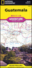
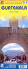
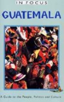
£9.99
Guatemala at 1:500, 000 on an indexed, double-sided, waterproof & tear-resistant adventure map from the National Geographic, prominently highlighting the country’s national parks & other protected areas including biospheres, volcanoes, etc. Topography is shown by contours at 200m intervals, with relief shading, graphics for swamps & coral reefs, & names of mountain ranges, peaks, passes, etc. Numerous protected areas are prominently highlighted, including national parks & reserves, biospheres & volcanic zones, . The map shows the country’s road network, including selected high clearance roads & local tracks. Railway lines are included & local airports are marked. Also shown are the boundaries & names of the administrative provinces. Symbols indicate various places of interest: UNESCO World Heritage sites, archaeological remains beaches & diving sites, etc. The map is indexed & has latitude & longitude lines at intervals of 30’. ...
Archived Product
£5.99
Guatemala & Belize at 1:500, 000 on an indexed road map with topographic & tourist information, printed on light, waterproof & tear-resistant plastic paper. The map, published by Rough Guides with cartography from the highly acclaimed World Mapping Project by the German publishers Reise Know-How, is double-sided to provide the best balance between a good scale & a convenient size sheet. The map divides the region north/south with a generous overlap & the whole of Belize on one side. Coverage extends south to San Salvador. Altitude colouring with contours & peak heights presents the topography. Seasonal rivers, swamps & coral reefs in the coastal waters are also marked. Road network

Includes::
local tracks & indicates driving distances on main routes. Railway lines & local airports are included. The map also shows internal administrative boundaries with names of the provinces. National parks & other protected areas are highlighted & a range of symbols mark various places of interest including UNESCO World Heritage sites, archaeological remains, beaches, etc. Latitude & longitude lines are drawn at intervals of 30

...
Archived Product
£9.50
Guatemala & Belize at 1:500, 000 on an indexed, waterproof & tear-resistant road map with topographic & tourist information, published by Reise Know-How as part of their highly acclaimed World Mapping Project. The map is double-sided to provide the best balance between a good scale & a convenient size sheet. The map divides the region north/south, with the whole of Belize on one side. On the southern side coverage

Includes::
much of El Salvador with San Salvador, & the westernmost part of Honduras. Topography is presented by altitude colouring & spot heights with names of mountain ranges, peaks, etc. Swamp areas, seasonal rivers & lakes, & along the coast coral reefs are also indicated. National parks & other protected areas are highlighted. Road network indicates toll routes,

Includes::
selected local roads & tracks, & shows border crossings & distances on main routes. Railway lines are included & local airports are marked. Internal administrative boundaries are shown with names of the provinces. Symbols indicate numerous places of interest, including UNESCO world heritage sites, archaeological sites, caves, beaches, etc. The map has a latitude & longitude grid at intervals of 30


...
Archived Product
£4.99
Guatemala City & Antigua in the Moon Spotlight guide series; covering a range of specific local cities, districts, areas & regions in North, Central & South America & targeted at those seeking to travel to a specific area within a country. Each of the guides has been extracted in full from the relevant country Moon Handbook & individual titles focus on a particular city, region or notable area of the destination. Many of the guides in the series are unique in their coverage, although are limited in putting the destination into its wider geographical context that a more comprehensive guide would provide. Stylistically, Moon ...
Archived Product
£8.99
Discover black sand beaches on the Pacific coast, a lake crowned by volcanoes & an ancient civilization that came to an abrupt end, leaving its history hidden within the ruins of jungle-clad temples. Travel from beautiful colonial cities & sleepy villages, to deserted beaches & lush rainforests. Footprint Guatemala covers all the top attractions in this colourful country, plus lesser-known sights off the beaten track. This new edition of features enhanced layout both inside & out, including an inspirational colour section, two-colour text, a highlights map, & an easy-to-locate contents page & practicalities section. This guide provides recommendations for all budgets on where to eat, sleep & sample tequila, as well as the low-down on the region`s best fiestas & adventure activities. Essentials section with practical advice on getting there & around. Highlights map so you know what not to miss. Comprehensive listings including where to eat, sleep & have fun. Detailed street maps for Guatemala City & other important towns & sights. Slim enough to fit in your pocket. Loaded with advice & information, this concise Footprint guide will help you get the most out of Guatemala without weighing you down. ...
Archived Product
£9.99
Indexed, double-sided map, printed on waterproof & tear-resistant paper, with street plans of Guatemala City & Antigua, plus an enlargement of the environs of the capital. The country is divided north/south with a generous overlap between the two sides. Elevation colouring with spot heights indicates the topography, with sand & swamp areas, as well as active volcanoes also marked. Road network

Includes::
seasonal tracks, & indicates intermediate distances on major & some minor roads plus locations of selected petrol stations. Railways, local airports & landing strips, ferry routes on Lake Izabal, plus the country’s local administrative boundaries with names of the provinces are also shown. National parks & biosphere reserves are clearly highlighted, with symbols showing archaeological sites, waterfalls, caves, mines, wells, etc. Latitude & longitude lines are drawn at 30’ intervals. The map has an extensive index of place names, with each side indexed separately. Insets show street plans of Guatemala City & Antigua, highlighting selected accommodation, shopping centres, bus terminals, places of interest, etc. Also included is an enlargement of the environs of the capital, including the volcanoes (Acatenango, de Fuego, & de Agua) lying to the south west.

...
Archived Product
£4.99
Guatemala's Western Highlands in the Moon Spotlight guide series; covering a range of specific local cities, districts, areas & regions in North, Central & South America & targeted at those seeking to travel to a specific area within a country. Each of the guides has been extracted in full from the relevant country Moon Handbook & individual titles focus on a particular city, region or notable area of the destination. Many of the guides in the series are unique in their coverage, although are limited in putting the destination into its wider geographical context that a more comprehensive guide would provide. Stylistically, Moon ...
Archived Product
£16.99
Guatemala, Belize & The Yucatan in the Insight Guide series is dedicated to exploring the destination in detail with a selection of glossy illustrations. Extensive introductory sections explore the region’s history & culture & there are also short articles written by locals about distinctive local issues. Selective photo-features illustrate the variety of the region. The ‘ Places’ section is organised by geographically & provides details of the area including places to visit, suggestions for tours & other activities. Each regional section has its own listings of the best restaurants, bars & cafes. Essential practical information is provided in the Travel Tips chapter on accommodation, shopping & local activities. A useful location finder & travel tip index with relevant page numbers are given on the inside covers.. ...
Archived Product
£19.50
Central Gauteng conurbation, including Johannesburg & Soweto, in an A4, spiral-bound street atlas from South Africa’s leading map publishers Map Studio. The atlas provides continuous mapping at 1:20, 000 of the area shown on our coverage image, with central Johannesburg shown in greater detail at 1:12, 500. The maps show the area with names of districts & suburbs & are annotated with an extensive range of symbols indicating various public buildings & cultural institutions, hotels & other accommodation, shopping centres, embassies & consulates, various places of interest, etc. Map legend with all the explanatory signs is conveniently placed under each set of double pages for easy reference. The atlas has an extensive street index & also

Includes::
a route planning map of the area with names of intersections, plus plans of the country’s international airports in Cape Town, Durban & Johannesburg.

...
Archived Product
£17.99
Topographic mapping from Mexico’s national survey agency, Instituto Nacional de Estadística, Geografía e Informática. The maps have contours at 20m intervals with relief shading & indicate various types of terrain & vegetation, e.g. dense vegetation, cultivated areas, swamps, sand dunes, salt pans, etc. UTM grid is at 10km intervals, with latitude & longitude shown by margin ticks at intervals of 5`. Map legend is in Spanish only. To see the other titles in this series please click on the series link. ...
Archived Product

Guatemala In Focus

Despite the arrival of the  New Dawn` as prophesised by the Maya, Guatemala is still a country beset with social tension and disparities in wealth. Topics covered include: History: From the classic Maya to the Colonial period; Politics: The long night of military rule, human rights and the peace process; Economy and Society: The wealth of the land, the private sector and development alternatives; Religion and culture: Religious diversity, Mayan identity and US influence. About this series:Given the turbulent history of many Central American and Latin American countries, travellers need as much information as they can get in order make the most of a visit. These illustrated titles offer up-to-date coverage of the main historical, economic, political, social and the environmental
issues affecting a country. Published by the Latin America Bureau, an independent research group working to broaden public understanding of issues of human rights and social and economic justice in Latin America and the Caribbean.
RIP - This product is no longer available on our network. It was last seen on 25.09.2019

This page now acts as a permanent archive for this product. Add more information using the comments box below to ensure it can still be found by future generations.

Use our search facility to see if it is available from an alternative contributor.
  • Availability: Out Of Stock
  • Supplier: Stanfords
  • SKU: 9781899365241
Availability: In Stock
£7.99

Product Description

Despite the arrival of the  New Dawn` as prophesised by the Maya, Guatemala is still a country beset with social tension & disparities in wealth. Topics covered include: History: From the classic Maya to the Colonial period; Politics: The long night of military rule, human rights & the peace process; Economy & Society: The wealth of the l&, the private sector & development alternatives; Religion & culture: Religious diversity, Mayan identity & US influence. About this series: Given the turbulent history of many Central American & Latin American countries, travellers need as much information as they can get in order make the most of a visit. These illustrated titles offer up-to-date coverage of the main historical, economic, political, social & the environmental issues affecting a country. Published by the Latin America Bureau, an independent research group working to broaden public understanding of issues of human rights & social & economic justice in Latin America & the Caribbean.

Reviews/Comments

Add New

Intelligent Comparison

Oooops!
We couldn't find anything!
Perhaps this product's unique.... Or perhaps we are still looking for comparisons!
Click to bump this page and we'll hurry up.

Price History

Vouchers

No voucher codes found.
Do you know a voucher code for this product or supplier? Add it to Insights for others to use.

Facebook

Jargon Buster

Tension - A force that is stretching an object
Tension - Also known as stress, a situation where a human can not cope with emotional or physical threats
Date - A day on a calendar
Date - A social activity whith a current or potential partner
Human - A highly developed and adapted mamal and deminant species on earth
History - Anything that happens in the past. An acedemic subject.
Caribbean - An area of islands within the Caribbean sea.
Classic - Something that is still like it was originally a high quality standard.

Supplier Information

Stanfords
Stanfords was established in 1853 and opened their iconic Covent Garden flagship store in 1901. They have become the top retailer of maps, travel books and accessories in the UK and arguably offer the largest selection of maps and travel books worldwide. Famous names such as Captain Robert Falcon Scott, Ranulph Fiennes and Michael Palin have purchased from Stanfords. They now have a shop in Bristol and both stores together with other venues operate a calendar of events including talks, book signings and exhibitions. As a specialist map retailer, the map selection is comprehensive and includes road maps, street maps and walking maps from worldwide destinations, as well as a selection of world atlases and wall maps. Books include travel guides and travel literature. Stanfords also stock globes, from miniatures made of blue marble to magnificent floor-standing globes. The website features a selection of interesting articles on travel topics.
Page Updated: 2023-11-12 20:15:36

Community Generated Product Tags

Oh No! The productWIKI community hasn't generated any tags for this product yet!
Menu