
 United Kingdom
 France
 Germany
 Netherlands
 Sweden
 USA
USA
 Italy
Italy
 Spain
Spain
More From Contributor


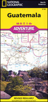
Guatemala Adventure Map
Guatemala at 1:500, 000 on an indexed, double-sided, waterproof and tear-resistant adventure map from the National Geographic, prominently highlighting the country’s national parks and other protected areas including biospheres, volcanoes, etc.Topography is shown by contours at 200m intervals, with relief shading, graphics for swamps and coral reefs, and names of mountain ranges, peaks, passes, etc. Numerous protected areas are prominently highlighted, including national parks and reserves, biospheres and volcanic zones, . The map shows the country’s road network, including selected high clearance roads and local tracks. Railway lines are included and local airports are marked. Also shown are the boundaries and names of the administrative provinces.Symbols indicate
various places of interest: UNESCO World Heritage sites, archaeological remains beaches and diving sites, etc. The map is indexed and has latitude and longitude lines at intervals of 30’.
various places of interest: UNESCO World Heritage sites, archaeological remains beaches and diving sites, etc. The map is indexed and has latitude and longitude lines at intervals of 30’.

Product Description
Reviews/Comments
Add New
Vouchers
No voucher codes found.
Do you know a voucher code for this product or supplier? Add it to Insights for others to use.
Do you know a voucher code for this product or supplier? Add it to Insights for others to use.
 Denmark