More From Contributor
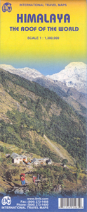
£16.50
Michael Palin reads his own entertainingly written account of his journey accross the countries of the Himalayas, accompanying a major BBC TV series in 2004. In his most challenging journey to date, Palin tackles the Himalayas, the greatest mountain range on earth. It is a virtually unbroken wall of rock stretching 1800 miles from the borders of Afghanistan to south-west China. Penetrated but never conquered, it remains the world's most majestic natural barrier, a magnificent wilderness that shapes the history & politics of Asia to this day. Having previously risen to the challenge of seas, poles, dhows & deserts, the highest mountains in the world were a natural target for Michael Palin. In a journey rarely, if ever, attempted before, in 6 months of hard travelling Palin takes on the full length of the Himalaya including the Khyber Pass, the hidden valleys of the Hindu Kush, ancient cities like Peshawar & Lahore, the mighty peaks of K2, Annapurna & Everest, the bleak & barren plateau of Tibet, the gorges of the Yangtze, the tribal lands of the Indo-Burmese border & the vast Brahmaputra delta in Bangladesh. He also passes through political flashpoints including Pakistan's remote north-west frontier, terrorist-torn Kashmir & the mountains of Nagal&. ...
Archived Product
£20.50
Michael Palin reads his own entertainingly written account of his journey accross the countries of the Himalayas, accompanying a major BBC TV series in 2004. In his most challenging journey to date, Palin tackles the Himalayas, the greatest mountain range on earth. It is a virtually unbroken wall of rock stretching 1800 miles from the borders of Afghanistan to south-west China. Penetrated but never conquered, it remains the world`s most majestic natural barrier, a magnificent wilderness that shapes the history & politics of Asia to this day. Having previously risen to the challenge of seas, poles, dhows & deserts, the highest mountains in the world were a natural target for Michael Palin. In a journey rarely, if ever, attempted before, in 6 months of hard travelling Palin takes on the full length of the Himalaya including the Khyber Pass, the hidden valleys of the Hindu Kush, ancient cities like Peshawar & Lahore, the mighty peaks of K2, Annapurna & Everest, the bleak & barren plateau of Tibet, the gorges of the Yangtze, the tribal lands of the Indo-Burmese border & the vast Brahmaputra delta in Bangladesh. He also passes through political flashpoints including Pakistan`s remote north-west frontier, terrorist-torn Kashmir & the mountains of Nagal&. ...
Archived Product
£14.95
Very large, indexed map presenting the Tibetan Plateau sitting on top of the arch of the Himalayas from the Karakoram to northern Burma. Colouring shows the influence of the monsoon on the terrain & its vegetation, contrasting the more arid plateau & the northern slopes against the forested, greener southern slopes. Across Tibet & in the Himalayas numerous spot heights show altitude of peaks & mountain passes. The region's dense network of rivers & lakes is shown with swamps, salt swamps & lakes, & seasonal rivers. Latitude & longitude lines are drawn at 1 ...
Archived Product
£21.99
A gorgeous work of literary journalism that follows a nomadic family`s fraught migration to the high Himalayan plains, as a changing world closes in around them. Following his vivid account of travelling with one of the last camel caravans on earth in Men of Salt, Michael Benanav now brings us along on a journey with a tribe of forest-dwelling nomads in India. Welcomed into a family of nomadic water buffalo herders, he joins them on their annual spring migration into the Himalayas. More than a glimpse into an endangered culture, this superb adventure explores the relationship between humankind & wild lands, & the dubious effect of environmental conservation on peoples whose lives are inseparably intertwined with the natural world. The migration Benanav embarked upon was plagued with problems, as government officials threatened to ban this nomadic family & others in the Van Gujjar tribe from the high alpine meadows where they had summered for centuries. Faced with the possibility that their beloved buffaloes would starve to death, & that their age-old way of life was doomed, the family charted a risky new course, which would culminating in an astonishing mountain rescue. & Benanav was arrested for documenting the story of their plight. Intimate & enthralling, Himalaya Bound paints a sublime picture of a rarely-seen world, revealing the hopes & fears, hardships & joys, of a people who wonder if there is still a place for them on this planet. Laced with stories of tribal cultures from India to Yellowstone, from Jordan to Kenya, Benanav deftly wends through the controversial terrain where Western ways of protecting the environment clash with indigenous understandings of nature. Himalaya Bound celebrates & mourns an ancient way of life, while revealing an unlikely battleground in the fight to save the earth. ...
Archived Product
£16.99
Himalaya by Bike in Trailblazer’s Adventure Travel Guide series is a route & planning guide for cyclists & motorcyclists looking for adventure, whether it’s a two-week holiday or a 6-month epic ride. Trailblazer’s Adventure Travel Guide series encompassing a range of guides is dedicated to adventurous activities in a range of worldwide destinations. The series

Includes::
outdoor activities such as cycling, motorcycling & overland treks through a wide variety of demanding landscapes, including the Himalaya, Morocco’s Atlas Mountains, the Sahara & the Silk Road. Each title in the series provides comprehensive pre-trip advice, including guidance on choosing a bike or mode of transport, route options, when to go, costs & money & health & safety considerations. Extensive route information is provided to guide travellers through the region’s most impressive sites in the most practical way. Strong on both practical content & cultural & historical background, Trailblazer Adventure Travel Guides feature unique h&-drawn GPS maps which show the distances between towns & villages, altitudes, places to eat & accommodation, water sources, fuel stations & points of interest along the way. Dedicated town & city guides are included throughout the guide, with advice for travellers on all budgets of recommended places to stay, places to eat & drink & what to see & do. Appendices also give information on subjects such as emergency medical facilities, basic language, embassies & general advice on adventure travel through the region & area.

...
Archived Product
£10.99
Edited & printed in 2015, on Polyart waterproof & tear resistant material, this Himalaya traveler`s map is up-to-date information for the region. Tourists, climbers & business people will find it very useful. Covers:
- Tibet- Kaschmir- Nepal- Sikkim
- Bhutan

...
Archived Product
£20.00
` The photos are of the climbs that have captured my imagination, have taken me out of myself, gripped with fear, shattered with exhaustion, or filled with wonder just to be there. If they stimulate & motivate others to take a step into the unknown, then this book will have been of some value.` Doug Scott`s historic ascent (with Dougal Haston) of the South-West Face of Everest in 1975 sparked a revolution in mountaineering, opening the way for climbers everywhere to adopt the rapid alpine style of ascent as they tackled the world`s highest peaks. As part of an elite international group of climbers, Scott soon completed a string of major climbs on Shishapangma, Shivling, Nuptse, & notably on Kangchenjunga, where his ascent of the north ridge (with Pete Boardman & Joe Tasker) ranks among the greatest of the Himalayan climbs. Himalayan Climber is a stunning pictorial record of Scott`s remarkable climbing career, covering 26 visits to the most fabled regions of the Greater Himalayan range, including the Hindu Kush, Tibet, the Karakoram, Ladakh, & Bhutan. Illustrated with over 400 dramatic colour photographs, Scott also narrates his adventures in other parts of the world: rock climbing in Derbyshire at the age of 11, bivouacking in freezing temperatures in the Alps & exploring the Atlas mountains as an aspirant climber. In over 30 years of Climbing, Scott has survived nights without oxygen at over 8, 700 metres, a nine-day crawling descent from the Ogre with two broken legs & an avalanche on K2 that swept away his climbing partner. Despite this, he is still passionate & lighthearted in his depiction of a life spent in the mountains. ...
Archived Product
£15.99
Himalayan Flowers of Nepal is a pictorial field guide featuring 65 families & 204 genera including 355 species of selected flowering plants from tropical & subtropical to temperate, subalpine & alpine regions. The book opens with a brief introduction on the geography, climate & types of vegetation of Nepal. It then arranges the flower & plants in alphabetical order & for each one it identifies the habitat, the altitude, the distribution in Nepal & the rest of Asia, the flowering months & how often it can be spotted. All individual entries benefit from a colour photograph & locator map, for easy identification. The appendix provides family & species scientific names making it an ideal for students, researcher & conservationist alike. ...
Archived Product
£9.99
Lava lamps may be out, but Himalayan salt lamps are in, & they`re taking mainstream culture by storm, popping up on retail shelves everywhere from gift & specialty to home decor. Unlike standard salt lamps that glow orange, our salt lamp will rotate through a rainbow of colors to suit every mood & bring some zen to any home, dorm room, or office. This kit

Includes::
a mini-size, color-changing Himalayan mood lamp made from real salt & a 32-page book with everything you need to know about salt lamps & the moods & meanings behind each color.

...
Archived Product
£12.99
As told with Peter Potterfield, award-winning mountaineering journalist, Viesturs narrates his successful quest to climb the 14 highest mountains of the world, those peaks above 8, 000 meters in height. Viesturs & Potterfield take readers along on some of the successes & failures of Viesturs` quest, including five separate ascents of Mount Everest (the tallest peak in the world) & the sheer triumph of the final two summits. The riveting tales of Viesturs` mountaineering adventures are illustrated by Viesturs` own stunning photographs, between 85 & 100 images, a photographic collection that is the primary focus of the book, a collection that shows like never before the deadly beauty & haunting menace of the Himalaya. Captions explain each photograph & its setting, describing both the heartbreaking tragedy Viesturs has faced & the ineffable joy he has experienced while striving at the limits of human endurance. ...
Archived Product

Himalaya ITMB

Himalayas at 1:1, 300, 000 from ITMB, providing coverage from Kabul and the Hindu Kush to the north-eastern states of India and eastern Tibet. The map is double-sided, with a separate index for each side, and drawn with north-northeast at the top.Coverage on one side extends from Kabul across northern Pakistan to Delhi, western Nepal and Mount Kailas in Tibet. On the reverse is the remainder of Nepal, Sikkim, Bhutan, southern Tibet with Lhasa and beyond, plus most the north-eastern states of India.Altitude colouring shows the topography, with additional graphics for glaciers, plus spot heights and names of individual mountain ranges. The map shows the region’s road and rail networks and highlights various places of interest. Within India, Pakistan and Afghanistan internal
administrative boundaries are shown with the names of the state/provinces. Latitude and longitude lines are drawn at intervals of 2°.
RIP - This product is no longer available on our network. It was last seen on 25.09.2019

This page now acts as a permanent archive for this product. Add more information using the comments box below to ensure it can still be found by future generations.

Use our search facility to see if it is available from an alternative contributor.
  • External links may include paid for promotion
  • Availability: Out Of Stock
  • Supplier: Stanfords
  • SKU: 9781553415480
Availability: In Stock
£9.99

Product Description

Himalayas at 1:1, 300, 000 from ITMB, providing coverage from Kabul & the Hindu Kush to the north-eastern states of India & eastern Tibet. The map is double-sided, with a separate index for each side, & drawn with north-northeast at the top. Coverage on one side extends from Kabul across northern Pakistan to Delhi, western Nepal & Mount Kailas in Tibet. On the reverse is the remainder of Nepal, Sikkim, Bhutan, southern Tibet with Lhasa & beyond, plus most the north-eastern states of India. Altitude colouring shows the topography, with additional graphics for glaciers, plus spot heights & names of individual mountain ranges. The map shows the region’s road & rail networks & highlights various places of interest. Within India, Pakistan & Afghanistan internal administrative boundaries are shown with the names of the state/provinces. Latitude & longitude lines are drawn at intervals of 2°.

Reviews/Comments

Add New

Price History

Vouchers

No voucher codes found.
Do you know a voucher code for this product or supplier? Add it to Insights for others to use.

Facebook

Jargon Buster

India - A subcontinent in Asia
Graphics - A general term for visual aspects of an item/display
Road - a manmade lane or a path that is used to speed up travel.
Altitude - Something that can be quite high in relation to sea or ground level.
Individual - A single separate item or person.

Supplier Information

Stanfords
Stanfords was established in 1853 and opened their iconic Covent Garden flagship store in 1901. They have become the top retailer of maps, travel books and accessories in the UK and arguably offer the largest selection of maps and travel books worldwide. Famous names such as Captain Robert Falcon Scott, Ranulph Fiennes and Michael Palin have purchased from Stanfords. They now have a shop in Bristol and both stores together with other venues operate a calendar of events including talks, book signings and exhibitions. As a specialist map retailer, the map selection is comprehensive and includes road maps, street maps and walking maps from worldwide destinations, as well as a selection of world atlases and wall maps. Books include travel guides and travel literature. Stanfords also stock globes, from miniatures made of blue marble to magnificent floor-standing globes. The website features a selection of interesting articles on travel topics.
Page Updated: 2023-11-12 20:15:36

Community Generated Product Tags

Oh No! The productWIKI community hasn't generated any tags for this product yet!
Menu